File:New England tornado paths.png
Jump to navigation
Jump to search

Size of this preview: 506 × 599 pixels. Other resolutions: 203 × 240 pixels | 564 × 668 pixels.
Original file (564 × 668 pixels, file size: 37 KB, MIME type: image/png)
Captions
Captions
Add a one-line explanation of what this file represents
| Description |
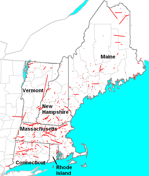
English: Approximate tracks of all tornadoes which affected New England from 1950 through 2006. Derived from an image created using SeverePlot, free software maintained by John Hart, lead forecaster for the Storm Prediction Center. |
|||
| Source | SeverePlot | |||
| Author | Own work, derived from image generated with public domain software. | |||
| Permission (Reusing this file) |
|
File history
Click on a date/time to view the file as it appeared at that time.
| Date/Time | Thumbnail | Dimensions | User | Comment | |
|---|---|---|---|---|---|
| current | 17:01, 13 May 2009 | | 564 × 668 (37 KB) | Runningonbrains (talk | contribs) | darkened state borders |
| 17:37, 4 February 2009 |  | 564 × 668 (37 KB) | Runningonbrains (talk | contribs) | Cropped a bit tighter | |
| 03:40, 3 February 2009 |  | 601 × 726 (40 KB) | Runningonbrains (talk | contribs) | {{Information |Description={{en|1=Approximate tracks of all w:tornadoes which affected w:New England from 1950 through 2006. Derived from an image created using [http://www.spc.noaa.gov/software/svrplot2/ SeverePlot], free software maintained by |
You cannot overwrite this file.
File usage on Commons
There are no pages that use this file.
File usage on other wikis
The following other wikis use this file:
- Usage on en.wikipedia.org