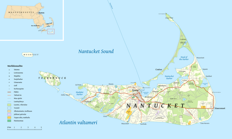
File:Nantucket map-fi.png
From Wikimedia Commons, the free media repository
Jump to navigation
Jump to search

Size of this preview: 800 × 481 pixels. Other resolutions: 320 × 192 pixels | 640 × 385 pixels | 1,024 × 616 pixels | 1,280 × 770 pixels | 2,560 × 1,539 pixels | 4,490 × 2,700 pixels.
Original file (4,490 × 2,700 pixels, file size: 2.52 MB, MIME type: image/png)
File information
Structured data
Captions
Captions
Add a one-line explanation of what this file represents
| DescriptionNantucket map-fi.png |
Suomi: Suomenkielinen Nantucketin saaren ja piirikunnan kartta. English: Map of the Nantucket Island and County in Finnish. |
| Date | (UTC) |
| Source | |
| Author |
User Halava except:
|
This file is licensed under the Creative Commons Attribution-Share Alike 3.0 Unported license.
- You are free:
- to share – to copy, distribute and transmit the work
- to remix – to adapt the work
- Under the following conditions:
- attribution – You must give appropriate credit, provide a link to the license, and indicate if changes were made. You may do so in any reasonable manner, but not in any way that suggests the licensor endorses you or your use.
- share alike – If you remix, transform, or build upon the material, you must distribute your contributions under the same or compatible license as the original.
Original upload log[edit]
This image is a derivative work of the following images:
- File:Map_symbols_US_NPS.svg licensed with PD-USGov-NPS
- 2006-12-21T21:56:24Z Pnw.hiker 745x923 (670003 Bytes) {{Information |Description= SVG map symbols from the US National Park Service |Source= http://www.nps.gov/hfc/carto/map-symbols.htm |Date= 26 July 2006 |Author= Tom Patterson, cartographer, Harpers Ferry Center, National Park
- File:MapSymbols_other_US_NPS.svg licensed with PD-USGov-NPS
- 2006-12-21T21:55:59Z Pnw.hiker 522x692 (468786 Bytes) {{Information |Description= SVG map symbols from the US National Park Service |Source= http://www.nps.gov/hfc/carto/map-symbols.htm |Date= 26 July 2006 |Author= Tom Patterson, cartographer, Harpers Ferry Center, National Park
- File:Map_of_Massachusetts_highlighting_Nantucket_County.svg licensed with PD-self
- 2006-02-12T12:50:01Z David Benbennick 2976x1819 (43712 Bytes) {{subst:User:Dbenbenn/clm|county=Nantucket County|state=Massachusetts|type=county}}
Uploaded with derivativeFX
File history
Click on a date/time to view the file as it appeared at that time.
| Date/Time | Thumbnail | Dimensions | User | Comment | |
|---|---|---|---|---|---|
| current | 20:28, 21 February 2011 |  | 4,490 × 2,700 (2.52 MB) | Halava (talk | contribs) | Some minor retouching |
| 21:53, 20 February 2011 |  | 4,484 × 2,700 (2.51 MB) | Halava (talk | contribs) | Slightly smaller version of the map. | |
| 20:55, 20 February 2011 |  | 5,000 × 3,011 (2.94 MB) | Halava (talk | contribs) | {{Information |Description={{fi|Suomenkielinen Nantucketin saaren ja piirikunnan kartta.}} {{en|Map of the Nantucket Island and County in Finnish.}} |Source=*Map data was downloaded from http://www.openstreetmap.org/ *File:Map_symbols_US_NPS.svg *[[ |
You cannot overwrite this file.
File usage on Commons
There are no pages that use this file.
File usage on other wikis
The following other wikis use this file:
- Usage on en.wikipedia.org
- Usage on fi.wikipedia.org
- Usage on fr.wikipedia.org
- Usage on hu.wikipedia.org
- Usage on la.wikipedia.org
- Usage on nl.wikipedia.org