File:Nansen Fram Expedition map-fr.svg
Jump to navigation
Jump to search

Size of this PNG preview of this SVG file: 800 × 480 pixels. Other resolutions: 320 × 192 pixels | 1,024 × 614 pixels | 1,280 × 768 pixels | 2,560 × 1,536 pixels.
Original file (SVG file, nominally 1,000 × 600 pixels, file size: 70 KB)
Captions
Captions
Add a one-line explanation of what this file represents
Summary[edit]
| Description |
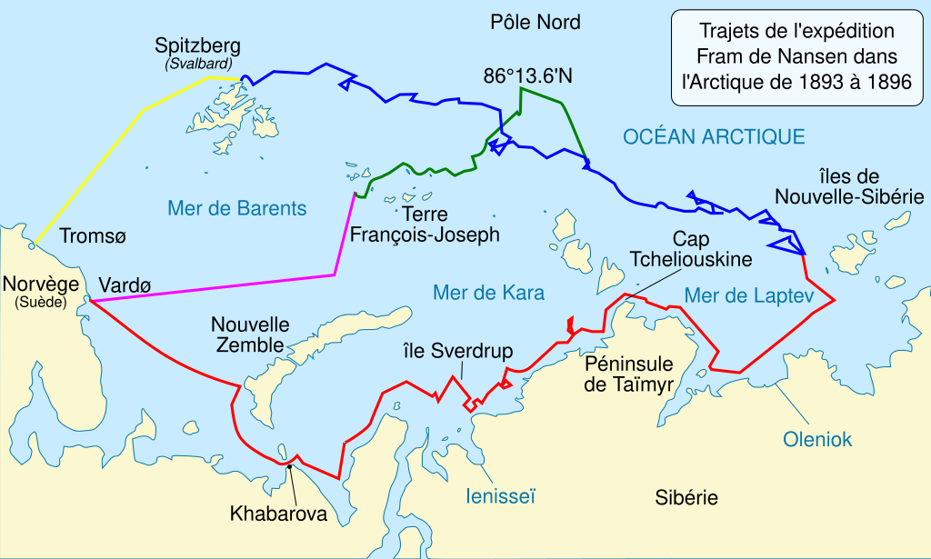
English: Map of the Arctic Ocean showing the routes taken during the 1893–96 Nansen's Fram expedition:
Frams's route eastward from Vardø to the Siberian coast, turning north at the New Siberian Islands to enter the pack ice. July – September 1893
Fram's drift in the ice from the New Siberian Islands, north and west to Spitsbergen, September 1893 – August 1896
Nansen and Johansen's march to Farthest North, 80°20'N, and their subsequent retreat to Cape Flora in Franz Josef Land. February 1895 – June 1896
Nansen and Johansen's return to Vardø from Cape Flora, August 1896
Fram's voyage from Spitsbergen to Tromsø, August 1896 Français : Carte des itinéraires suivis par l'expédition Fram de Fridtjof Nansen de 1893 à 1896 :
Trajet du Fram vers l'est, depuis Vardø en Norvège jusqu'aux côtes de Sibérie, puis vers le nord après les îles de Nouvelle-Sibérie pour entrer dans le pack de glace. De juillet à septembre 1893
Dérive du Fram dans la banquise depuis les îles de Nouvelle-Sibérie vers Spitzberg, suivant une direction nord puis ouest. De septembre 1893 à août 1896.
Marche de Nansen et Johansen vers le grand nord, jusqu'à la latitude 80°20'N, et leur retraire vers le cap Flora sur la terre de François-Joseph. De février 1895 à juin 1896.
Retour de Nansen et Johansen à Vardø depuis le cap Flora. Août 1896.
Retour du Fram de Spitzberg à Tromsø. Août 1896. |
||
| Date | |||
| Source | |||
| Author |
|
||
| Other versions | |||
| Attribution (required by the license) | © Sémhur / Wikimedia Commons / | ||
| SVG | W3C-validity not checked.
|
||
| Graphic Lab |

| Camera location | | View this and other nearby images on: OpenStreetMap |
|---|
Licensing[edit]
I, the copyright holder of this work, hereby publish it under the following licenses:
| Copyleft: This work of art is free; you can redistribute it and/or modify it according to terms of the Free Art License. You will find a specimen of this license on the Copyleft Attitude site as well as on other sites. |
This file is licensed under the Creative Commons Attribution-Share Alike 4.0 International, 3.0 Unported, 2.5 Generic, 2.0 Generic and 1.0 Generic license.
- You are free:
- to share – to copy, distribute and transmit the work
- to remix – to adapt the work
- Under the following conditions:
- attribution – You must give appropriate credit, provide a link to the license, and indicate if changes were made. You may do so in any reasonable manner, but not in any way that suggests the licensor endorses you or your use.
- share alike – If you remix, transform, or build upon the material, you must distribute your contributions under the same or compatible license as the original.
You may select the license of your choice.
Original upload log[edit]
This image is a derivative work of the following images:
- File:Nansen_Fram_Map.svg licensed with Cc-by-sa-3.0,2.5,2.0,1.0, GFDL
- 2009-10-16T17:03:20Z Beao 1003x601 (179550 Bytes) Tweak.
- 2009-10-16T17:01:05Z Beao 1003x601 (179286 Bytes) Tweak.
- 2009-10-16T16:58:06Z Beao 1003x601 (179263 Bytes) Removed flowRoot
- 2009-10-16T16:49:15Z Beao 1003x601 (194813 Bytes) Redrew lines and deleted link to image.
- 2009-10-16T14:27:37Z Ruhrfisch 1052x744 (870023 Bytes) == Summary == {{Information |Description = Map of the Arctic Ocean showing the routes taken during the 1893–96 [[w:Nansen's Fram expedition|Nansen's Fram expedition]]: {{legend|red|Frams's route eastward from Vardø to th
Uploaded with derivativeFX
File history
Click on a date/time to view the file as it appeared at that time.
| Date/Time | Thumbnail | Dimensions | User | Comment | |
|---|---|---|---|---|---|
| current | 18:38, 4 July 2011 | | 1,000 × 600 (70 KB) | Sémhur (talk | contribs) | cap Chelyuskin ⋅⋅> cap Tcheliouskine ; Khamarova |
| 13:30, 4 July 2011 |  | 1,003 × 601 (69 KB) | Sémhur (talk | contribs) | == {{int:filedesc}} == {{Information |Description={{Multilingual description |en= Map of the Arctic Ocean showing the routes taken during the 1893–96 Nansen's Fram expedition: {{Legend||1px red line|line=Frams's route east |
You cannot overwrite this file.
File usage on Commons
There are no pages that use this file.
File usage on other wikis
The following other wikis use this file:
- Usage on fr.wikipedia.org