File:Naaraim 1898 -1946.jpg
Jump to navigation
Jump to search

Size of this preview: 800 × 593 pixels. Other resolutions: 320 × 237 pixels | 640 × 475 pixels | 1,024 × 759 pixels | 1,280 × 949 pixels | 2,560 × 1,898 pixels | 4,676 × 3,467 pixels.
Original file (4,676 × 3,467 pixels, file size: 3.69 MB, MIME type: image/jpeg)
Captions
Captions
Add a one-line explanation of what this file represents
Summary[edit]
| Description |
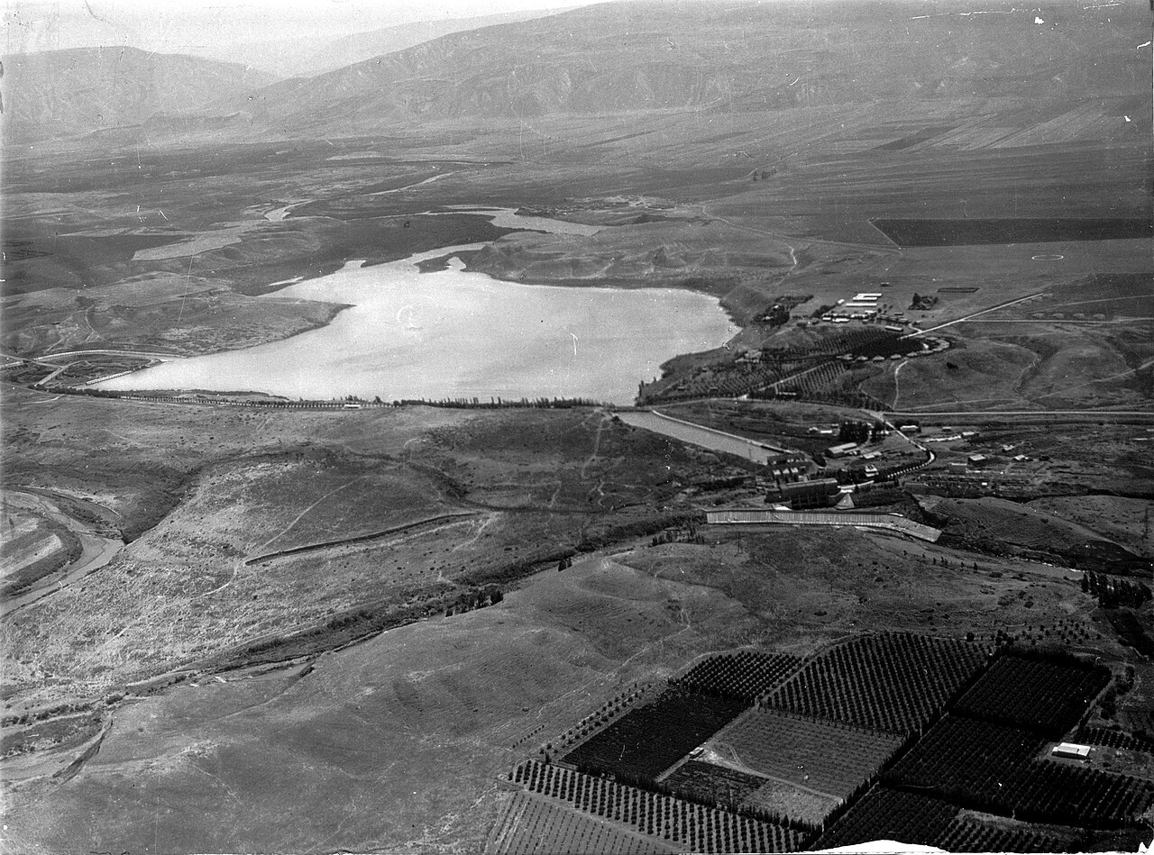
Deutsch: Luftbild des Jarmukstausees (nach 1948 trocken gefallen) ostwärts blickend, d.h. den Jarmuk stromaufwärts. Der Fluss bildet im Bereich des Photos die Grenze zwischen Transjordanien (heute Jordanien, südlich des Jarmuks) und dem Mandatsgebiet Palästina (hier heute Israel, nördlich des Flusses). Stomaufwärts nach einer Biegung liegt die (trans)jordanische Ortschaft al-Baqura am SÜfufer des Jarmuks. Von links, d.h. von Norden, mündet der Jordan-Jarmuk-Kanal (nach 1948 trocken gefallen) nach einer letzten Biegung in den Stausee, den nach Südwesten der obere Wasserablauf verlässt in Richtung Wasserkraftwerk Naharajim. Dessen unterer Wasserablauf ist durch eine Betonwand vom Jordan im Bildvordergrund getrennt, wobei der unterer Wasserablauf in einem Geländeinschnitt östlich des Jordan weiterfließt und südlich außerhalb des Bildes in den Jordan mündet. Den Jordan-Jarmuk-Kanal überspannt eine Straßenbrücke, die erhalten ist. Westlich der Mündung des Kanals in den Stausee verläuft der 1928-1932 erbaute Jarmukdamm, im Bild die weiße Betonmauer am Nordende des Stausees, die die Wasser des Jarmuks soweit aufstaut, dass sie durch den oberen Wasserablauf südwestwärts zum Kraftwerk abgeleitet werden können. Am Westende des Damms verlässt der Jarmuk den Stausee (im Bild kaum zu erkennen) nordwestwärts, um außerhalb des Bildes weiter nördlich in den Jordan zu münden. Eine Straße und die parallele hier eingleisige Bahnstrecke Haifa–Darʿa erstrecken sich entlang der langen Westseite des Stausees. Etwas südlich der Mitte der langen Westseite des stausees befindet sich ein weißes Gebäude, der 1928 eröffnete Bahnhof Naharajim. Auf dem Hügel namens Tel Or befindet sich ein Halbkreis von Häusern für Kraftwerksmitarbeiter, der sich nach Norden öffnet. Vorn rechts im Bild sind Plantagen im damaligen Mandatsgebiet Palästina, hier seit 1948 Teil Israels. Aufnahme zwischen 1932-1946
English: Aerial photograph of the Yarmuk Reservoir looking eastwards, i.e. upstream the Yarmuk, forming the border between Transjordan (now Jordan) and Mandatory Palestine (here now Israel). Coming from the left, i.e. North, the Jordan–Yarmuk Canal (now dry) empties after a last curve into the Reservoir, to the southwest the Head Race Canal leaves the reservoir towards the Naharayim Hydro-Electric Power Plant, whose Tail Race Canal is dammed off by a concrete wall from the river Jordan in the foreground of the photo, with the tail race canal continuing in the cutting a bit behind the Jordan only to join that river more southerly outside the photograph. The Jordan–Yarmuk Canal is spanned over by a road bridge, preserved. West of the canal mouth into the reservoir stretches the Yarmuk Dam, a white concrete wall, damming up the waters of the Yarmuk to that level that waters can be directed through the head race canal to the power plant. At the western end of the dam the Yarmuk leaves the reservoir (hardly visible) northwestwards only to join the Jordan more northerly outside the photograph. A road and the parallel single track of the Haifa–Darʿa Railway pass along the long western front of the reservoir. A bit south of the midst of the western stretch of the reservoir a white building indicates the Naharayim Train Station. On the top of the hill, called Tel Or a semicircular series of houses for power plant employees opens to the north. 1932-1946
Original caption: "View of plain and lake, probably in Palestine "
| ||
| Medium/Size | 1 transparency: glass / height: 4 in (10.1 cm); width: 5 in (12.7 cm). | ||
| Notes |
|
||
| Date | from 1898 until 1946 | ||
| Source |
|
||
| Author | Either by the American Colony Photo Department or its successor, the Matson Photo Service. |

Licensing[edit]
| This work is from the Matson (G. Eric and Edith) Photograph collection at the Library of Congress. According to the library, there are no known copyright restrictions on the use of this work. The only restrictions concern color lantern slides, which this photo is not. |
 |
File history
Click on a date/time to view the file as it appeared at that time.
| Date/Time | Thumbnail | Dimensions | User | Comment | |
|---|---|---|---|---|---|
| current | 12:21, 4 April 2024 | | 4,676 × 3,467 (3.69 MB) | Ulf Heinsohn (talk | contribs) | Reverted to version as of 22:05, 29 January 2023 (UTC) the photo was uploaded in a mirrored version, then corrected before being reverted to mirrored, thus now to be corrected again |
| 20:27, 30 January 2023 |  | 4,676 × 3,467 (9.46 MB) | Geagea (talk | contribs) | Reverted to version as of 04:33, 26 November 2014 (UTC) - בבקשה העלה בקובץ חדש | |
| 22:05, 29 January 2023 |  | 4,676 × 3,467 (3.69 MB) | דג קטן (talk | contribs) | היפוך ראי לתמונה כדי שתתאים למציאות | |
| 04:33, 26 November 2014 |  | 4,676 × 3,467 (9.46 MB) | Geagea (talk | contribs) | crop | |
| 04:28, 26 November 2014 |  | 4,978 × 3,848 (9.71 MB) | Geagea (talk | contribs) | larger | |
| 00:01, 6 June 2008 |  | 640 × 495 (56 KB) | Daniel Ventura (talk | contribs) | {{Information |Description={{en|1=Naaraim_1898_-1946}} |Source=from http://lcweb2.loc.gov/pp/matpchtml/matpcback.html |Author=American Colony (Jerusalem). Photo Dept., photographer |Date= |Permission= |other_versions= }} {{ImageUpload|full}} |
You cannot overwrite this file.
File usage on Commons
The following 2 pages use this file:
File usage on other wikis
The following other wikis use this file: