File:NPS yellowstone-old-faithful-area-trail-map.gif
Jump to navigation
Jump to search

Size of this preview: 473 × 599 pixels. Other resolutions: 189 × 240 pixels | 593 × 751 pixels.
Original file (593 × 751 pixels, file size: 36 KB, MIME type: image/gif)
Captions
Captions
Add a one-line explanation of what this file represents
Summary[edit]
| Description |
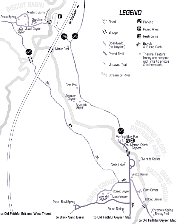
English: Here’s another Old Faithful area trail map, showing the northwest continuation of the previous map, including Riverside Geyser, Giant Geyser, Morning Glory Pool, and the Biscuit Basin. |
| Date | |
| Source | U.S. National Park Service (http://npmaps.com/wp-content/uploads/yellowstone-old-faithful-area-trail-map.gif) |
| Author | U.S. National Park Service, restoration/cleanup by Matt Holly |
Licensing[edit]
| This image or media file contains material based on a work of a National Park Service employee, created as part of that person's official duties. As a work of the U.S. federal government, such work is in the public domain in the United States. See the NPS website and NPS copyright policy for more information. |
File history
Click on a date/time to view the file as it appeared at that time.
| Date/Time | Thumbnail | Dimensions | User | Comment | |
|---|---|---|---|---|---|
| current | 10:06, 17 May 2017 | | 593 × 751 (36 KB) | RKBot (talk | contribs) | =={{int:filedesc}}== {{Information |description= {{en|1=Here’s another Old Faithful area trail map, showing the northwest continuation of the previous map, including Riverside Geyser, Giant Geyser, Morning Glory Pool, and the Biscuit Basin.}} |date=... |
You cannot overwrite this file.
File usage on Commons
The following page uses this file: