File:NPS devils-postpile-geologic-map.jpg
Jump to navigation
Jump to search

Size of this preview: 800 × 545 pixels. Other resolutions: 320 × 218 pixels | 640 × 436 pixels | 1,024 × 698 pixels | 1,280 × 873 pixels | 2,560 × 1,746 pixels | 4,259 × 2,904 pixels.
Original file (4,259 × 2,904 pixels, file size: 2.91 MB, MIME type: image/jpeg)
Captions
Captions
Add a one-line explanation of what this file represents
Summary[edit]
| Description |
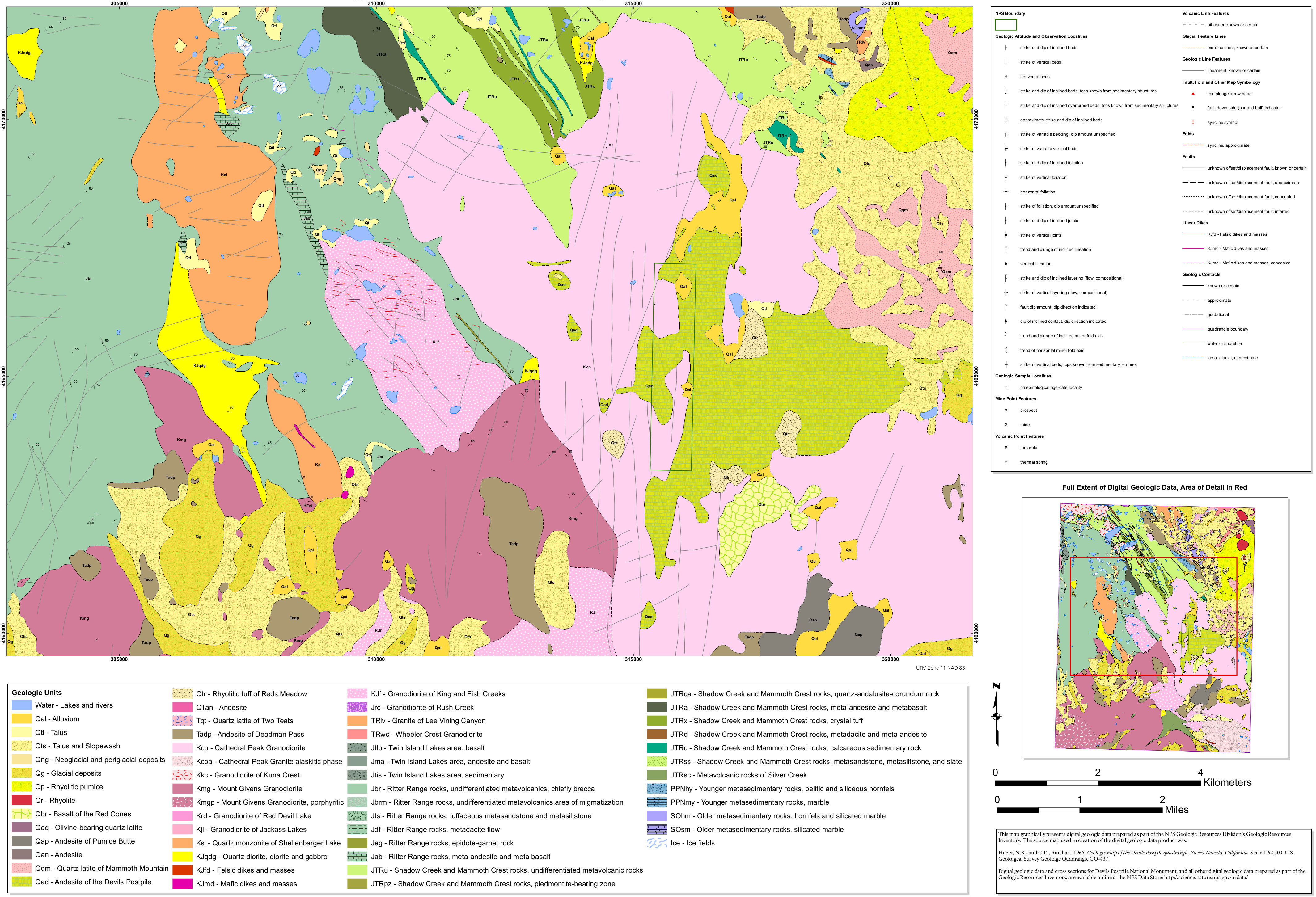
English: The geologic map of Devils Postpile includes both the monument as well as the surrounding Sierra Nevada, including Mount Ritter and the Ritter Range in the Ansel Adams Wilderness. |
| Date | |
| Source | U.S. National Park Service (http://npmaps.com/wp-content/uploads/devils-postpile-geologic-map.jpg) |
| Author | U.S. National Park Service, restoration/cleanup by Matt Holly |
Licensing[edit]
| This image or media file contains material based on a work of a National Park Service employee, created as part of that person's official duties. As a work of the U.S. federal government, such work is in the public domain in the United States. See the NPS website and NPS copyright policy for more information. |
File history
Click on a date/time to view the file as it appeared at that time.
| Date/Time | Thumbnail | Dimensions | User | Comment | |
|---|---|---|---|---|---|
| current | 21:06, 16 May 2017 | | 4,259 × 2,904 (2.91 MB) | RKBot (talk | contribs) | =={{int:filedesc}}== {{Information |description= {{en|1=The geologic map of Devils Postpile includes both the monument as well as the surrounding Sierra Nevada, including Mount Ritter and the Ritter Range in the Ansel Adams Wilderness.}} |date= 2017-01... |
You cannot overwrite this file.
File usage on Commons
The following page uses this file:
Categories:
- Maps of Devils Postpile National Monument
- Geological maps of California
- Quaternary alluvium in California
- Quaternary talus in California
- Quaternary neoglacial deposits in California
- Quaternary periglacial deposits in California
- Quaternary glacial deposits in California
- Quaternary rhyolitic pumice in California
- Quaternary rhyolite in California
- Quaternary basalt of the Red Cones
- Quaternary olivine-bearing quartz latite
- Andesite of Pumice Butte
- Quaternary andesite in California
- Quaternary latite of Mammoth Mountain
- Volcanological maps of California
- Andesite of Devils Postpile
- Rhyolitic tuff of Reds Meadow
- Neogene andesite in California
- Quartz latite of Two Teats
- Andesite of Deadman Pass
- Maps of the Mono-Inyo Craters
- Quaternary eruption products in California
- Mount Ritter
- Ansel Adams Wilderness
- Geological maps of the Ritter Range
- Cathedral Peak Granodiorite
- Granodiorite of Kuna Crest
- Mount Givers Granodiorite
- Granodiorite of Red Devil Lake
- Granodiorite of Jackass Lakes
- Quartz monzonite of Shellenbarger Lake
- Cretaceous diorite intrusions in California
- Jurassic diorite intrusions in California
- Cretaceous grabbroic intrusions in California
- Jurassic gabbroic intrusions in California
- Cretaceous felsic intrusions in California
- Jurassic felsic intrusions in California
- Cretaceous mafic intrusions in California
- Jurassic mafic intrusions in California
- Granodiorite of King Creek
- Granodiorite of Fish Creek
- Granodiorite of Rush Creek
- Granite of Lee Vining Canyon
- Wheeler Crest Granodiorite
- Basalt from the Twin Island Lakes area
- Andesite from the Twin Island Lakes area
- Jurassic sedimentary rocks from the Twin Island Lakes area
- Jurassic breccia of the Ritter Range
- Jurassic metamorphic rocks of the Ritter Range (tuffaceous metasedimentary)
- Metadacite flow in the Ritter Range
- Epidote-garnet rocks of the Ritter Range
- Jurassic metaandesite of the Ritter Range
- Jurassic metabasalt of the Ritter Range
- Jurassic metavolcanic rocks of Mammoth Crest and Shadow Creek
- Jurassic metabasalt of Mammoth Crest and Shadow Creek
- Triassic metabasalt of Mammoth Crest and Shadow Creek
- Jurassic metaandesite of Mammoth Crest and Shadow Creek
- Triassic metaandesite of Mammoth Crest and Shadow Creek
- Jurassic metadacite of Mammoth Crest and Shadow Creek
- Triassic metadacite of Mammoth Crest and Shadow Creek
- Jurassic metasedimentary rocks of Mammoth Crest and Shadow Creek
- Triassic metasedimentary rocks of Mammoth Crest and Shadow Creek
- Jurassic sedimentary rocks of Mammoth Crest and Shadow Creek
- Triassic sedimentary rocks of Mammoth Crest and Shadow Creek
- Jurassic metavolcanic rocks of Silver Creek
- Triassic metavolcanic rocks of Silver Creek
- Permian metasedimentary rocks in California
- Pennsylvanian metasedimentary rocks in California
- Marble in California
- Silurian metasedimentary rocks in California
- Ordovician metasedimentary rocks in California
- Glaciers of California
- Faults in California
- Tilted strata in California
- Folds in California
- Geological maps of Mammoth Mountain
- Periglacial deposits