File:Muscovy1715.jpg
Jump to navigation
Jump to search

Size of this preview: 800 × 576 pixels. Other resolutions: 320 × 230 pixels | 640 × 461 pixels | 1,024 × 737 pixels | 1,143 × 823 pixels.
Original file (1,143 × 823 pixels, file size: 841 KB, MIME type: image/jpeg)
Captions
Captions
Add a one-line explanation of what this file represents
| Description |
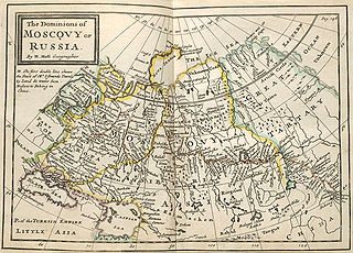
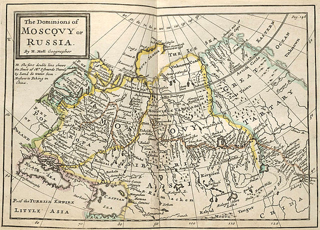
Русский: «Владения Московии или России». Карта из сборника Германа Молла "Twenty four new and accurate maps of the several parts of Europe". Лондон, 1715?
English: Map of dominions of Moscovy or Russia. From: Moll, Herman, Twenty four new and accurate maps of the several parts of Europe ... : all (except the last) new done, according to the latest observations / by Herman Moll, London, 1715? |
||||
| Date | |||||
| Source | Beinecke Rare Book and Manuscript Library, Yale University, USA | ||||
| Author | Moll, Herman. Uploaded by Nickpo. | ||||
| Permission (Reusing this file) |
|
||||
| Other versions | Compare with: File:Growth of Russia 1613-1914.png | ||||
File history
Click on a date/time to view the file as it appeared at that time.
| Date/Time | Thumbnail | Dimensions | User | Comment | |
|---|---|---|---|---|---|
| current | 12:57, 16 July 2009 | | 1,143 × 823 (841 KB) | Nickpo (talk | contribs) | {{Information |Description={{ru|«Владения Московии или России». Карта из сборника Германа Молла "Twenty four new and accurate maps of the several parts of Europe". Лондон, 1715?}} {{en|Map of dom |
| 12:57, 16 July 2009 |  | 1,143 × 823 (841 KB) | Nickpo (talk | contribs) | {{Information |Description={{ru|«Владения Московии или России». Карта из сборника Германа Молла "Twenty four new and accurate maps of the several parts of Europe". Лондон, 1715?}} {{en|Map of dom |
You cannot overwrite this file.
File usage on Commons
There are no pages that use this file.
File usage on other wikis
The following other wikis use this file:
- Usage on be-tarask.wikipedia.org
- Usage on be.wikipedia.org
- Usage on ca.wikipedia.org
- Usage on en.wikipedia.org
- Usage on es.wikipedia.org
- Usage on ka.wikipedia.org
- Usage on pt.wikipedia.org
- Usage on uk.wikipedia.org
- Usage on xmf.wikipedia.org