File:Mudflow covering SR 504 near Coal Bank bridge, July 1980.jpg
Jump to navigation
Jump to search

Size of this preview: 800 × 535 pixels. Other resolutions: 320 × 214 pixels | 640 × 428 pixels | 1,024 × 685 pixels | 1,280 × 856 pixels | 2,560 × 1,712 pixels | 3,483 × 2,329 pixels.
Original file (3,483 × 2,329 pixels, file size: 9.98 MB, MIME type: image/jpeg)
Captions
Captions
Add a one-line explanation of what this file represents
Summary[edit]
| Description |
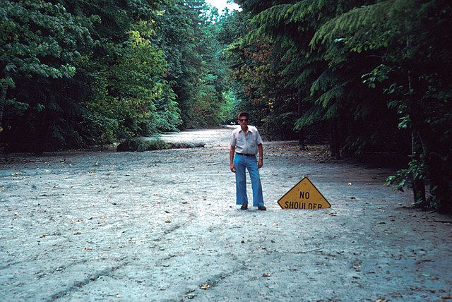
English: Sedimentary deposits from the lahar of Mount St. Helens's May 1980 eruption, seen covering State Route 504 a few months later. USGS employee Gordon Coyier is seen posing next to a buried highway sign. |
| Date | |
| Source | USGS Denver Library Photographic Collection |
| Author | R. L. Schuster (United States Geological Survey) |
Licensing[edit]
This image is in the public domain in the United States because it only contains materials that originally came from the United States Geological Survey, an agency of the United States Department of the Interior. For more information, see the official USGS copyright policy.
|
File history
Click on a date/time to view the file as it appeared at that time.
| Date/Time | Thumbnail | Dimensions | User | Comment | |
|---|---|---|---|---|---|
| current | 09:07, 11 September 2018 | | 3,483 × 2,329 (9.98 MB) | SounderBruce (talk | contribs) | User created page with UploadWizard |
You cannot overwrite this file.
File usage on Commons
The following page uses this file:
File usage on other wikis
The following other wikis use this file:
- Usage on cs.wikipedia.org
- Usage on en.wikipedia.org