File:Mount Mazama map-fr.svg
Jump to navigation
Jump to search

Size of this PNG preview of this SVG file: 800 × 597 pixels. Other resolutions: 320 × 239 pixels | 640 × 478 pixels | 1,024 × 764 pixels | 1,280 × 955 pixels | 2,560 × 1,911 pixels | 2,034 × 1,518 pixels.
Original file (SVG file, nominally 2,034 × 1,518 pixels, file size: 2.98 MB)
Captions
Captions
Add a one-line explanation of what this file represents
Summary[edit]
| Description |
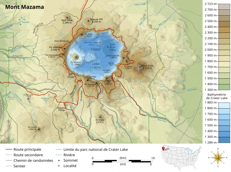
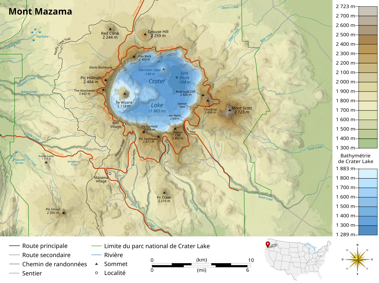
English: Map of Mount Mazama, Oregon, United States of America.
Français : Carte du mont Mazama, Oregon, États-Unis d'Amérique. |
||
| Date | |||
| Source |
English: * Lakes, rivers, borders: [www.openstreetmap.fr OpenStreetMap] (CC-BY-SA-2.0)
Français : * Lacs, rivières, limites : [www.openstreetmap.fr OpenStreetMap] (CC-BY-SA-2.0)
|
||
| Author |
|
||
| Other versions | |||
| Attribution (required by the license) | © Sémhur / Wikimedia Commons / | ||
| SVG development |
|

| Object location | | View this and other nearby images on: OpenStreetMap |
|---|
Licensing[edit]
I, the copyright holder of this work, hereby publish it under the following licenses:
| Copyleft: This work of art is free; you can redistribute it and/or modify it according to terms of the Free Art License. You will find a specimen of this license on the Copyleft Attitude site as well as on other sites. |
This file is licensed under the Creative Commons Attribution-Share Alike Attribution-Share Alike 4.0 International, 3.0 Unported, 2.5 Generic, 2.0 Generic and 1.0 Generic license.
- You are free:
- to share – to copy, distribute and transmit the work
- to remix – to adapt the work
- Under the following conditions:
- attribution – You must give appropriate credit, provide a link to the license, and indicate if changes were made. You may do so in any reasonable manner, but not in any way that suggests the licensor endorses you or your use.
- share alike – If you remix, transform, or build upon the material, you must distribute your contributions under the same or compatible license as the original.
You may select the license of your choice.
File history
Click on a date/time to view the file as it appeared at that time.
| Date/Time | Thumbnail | Dimensions | User | Comment | |
|---|---|---|---|---|---|
| current | 20:43, 11 November 2019 | | 2,034 × 1,518 (2.98 MB) | Sémhur (talk | contribs) | |
| 20:41, 11 November 2019 |  | 2,034 × 1,518 (2.98 MB) | Sémhur (talk | contribs) | Valid SVG | |
| 20:26, 11 November 2019 |  | 2,034 × 1,518 (2.98 MB) | Sémhur (talk | contribs) | == {{int:filedesc}} == {{Information |Description= {{en|1= Map of {{w|Mount Mazama||en}}, Oregon, United States of America.}} {{fr|1= Carte du {{w|mont Mazama||fr}}, Oregon, États-Unis d'Amérique.}} |Source= * Lakes, rivers, borders: [www.openstreetmap.fr OpenStreetMap] (CC-BY-SA-2.0) * Topography and relief: [https://earthdata.nasa.gov/ earthdata.nasa.gov] (public domain) with ASTER data. ''ASTER GDEM is a product of METI and NASA'' * Bathymetry of Crater Lake: {{cite web |author=Robinson, J... |
You cannot overwrite this file.
File usage on Commons
The following 4 pages use this file:
File usage on other wikis
The following other wikis use this file:
- Usage on fr.wikipedia.org
- Usage on it.wikipedia.org