File:Mount Mazama hazard map-fr.svg
Jump to navigation
Jump to search

Size of this PNG preview of this SVG file: 622 × 600 pixels. Other resolutions: 249 × 240 pixels | 498 × 480 pixels | 797 × 768 pixels | 1,062 × 1,024 pixels | 2,124 × 2,048 pixels | 2,281 × 2,199 pixels.
Original file (SVG file, nominally 2,281 × 2,199 pixels, file size: 6.48 MB)
Captions
Captions
Add a one-line explanation of what this file represents
Summary[edit]
| Description |
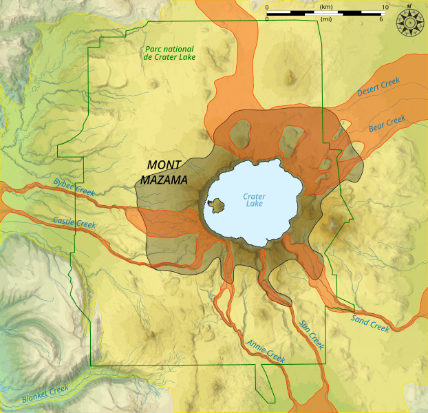
English: Map of volcanic hazards of Mount Mazama, Oregon, United States of America.
Lava and pyroclastic flows, ejectas, rock fall
Lahars
Volcanic ash
Crater Lake National Park boundary Français : Carte des risques volcaniques du mont Mazama, Oregon, États-Unis d'Amérique.
Coulées de laves et pyroclastiques, éjectas, chute de roches
Lahars
Cendre volcanique
Limites du parc national de Crater Lake |
||
| Date | |||
| Source |
English: * Lakes, rivers, borders: [www.openstreetmap.fr OpenStreetMap] (CC-BY-SA-2.0)
Français : * Lacs, rivières, limites : [www.openstreetmap.fr OpenStreetMap] (CC-BY-SA-2.0)
|
||
| Author | |||
| Other versions | |||
| Attribution (required by the license) | © Sémhur / Wikimedia Commons / | ||
| SVG development |
|

| Object location | | View this and other nearby images on: OpenStreetMap |
|---|
Licensing[edit]
I, the copyright holder of this work, hereby publish it under the following licenses:
| Copyleft: This work of art is free; you can redistribute it and/or modify it according to terms of the Free Art License. You will find a specimen of this license on the Copyleft Attitude site as well as on other sites. |
This file is licensed under the Creative Commons Attribution-Share Alike Attribution-Share Alike 4.0 International, 3.0 Unported, 2.5 Generic, 2.0 Generic and 1.0 Generic license.
- You are free:
- to share – to copy, distribute and transmit the work
- to remix – to adapt the work
- Under the following conditions:
- attribution – You must give appropriate credit, provide a link to the license, and indicate if changes were made. You may do so in any reasonable manner, but not in any way that suggests the licensor endorses you or your use.
- share alike – If you remix, transform, or build upon the material, you must distribute your contributions under the same or compatible license as the original.
You may select the license of your choice.
File history
Click on a date/time to view the file as it appeared at that time.
| Date/Time | Thumbnail | Dimensions | User | Comment | |
|---|---|---|---|---|---|
| current | 21:33, 19 November 2019 | | 2,281 × 2,199 (6.48 MB) | Sémhur (talk | contribs) | == {{int:filedesc}} == {{Information |Description= {{en|1= Map of {{w|volcanic hazards||en}} of {{w|Mount Mazama||en}}, Oregon, United States of America. {{legend|#aaa788|Lava and pyroclastic flows, ejectas, rock fall}} {{legend|#e59b36|Lahars}} {{legend|#cdcb54|Volcanic ash}} {{legend||line=darkgray dotted 1px|Crater Lake National Park boundary}} }} {{fr|1= Carte des {{w|Risque volcanique|risques volcaniques|fr}} du {{w|mont Mazama||fr}}, Oregon, États-Unis d'Amérique. {{legend|#aaa788|Coulé... |
You cannot overwrite this file.
File usage on Commons
The following 4 pages use this file:
File usage on other wikis
The following other wikis use this file:
- Usage on fr.wikipedia.org
- Usage on it.wikipedia.org