File:Massif du Mont-Blanc depuis Vétraz.jpg
Jump to navigation
Jump to search

Size of this preview: 800 × 372 pixels. Other resolutions: 320 × 149 pixels | 640 × 298 pixels | 1,024 × 476 pixels | 1,280 × 596 pixels | 3,888 × 1,809 pixels.
Original file (3,888 × 1,809 pixels, file size: 4.47 MB, MIME type: image/jpeg)
Captions
Captions
Add a one-line explanation of what this file represents
Summary[edit]
-
 PNG from RAW file
 -


| Description |
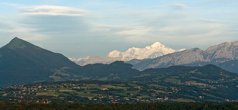
English: Mont Blanc Massif from Vétraz-Monthoux (60 km), Haute-Savoie. From left to right, Aiguille Verte and Grand Dru, Aiguille du Midi, Mont Blanc du Tacul, Mont Maudit, Mont Blanc, Aiguille de Bionnassay. In front, Dôme and Aiguille du Goûter.
Français : Massif du Mont-Blanc depuis Vétraz-Monthoux (60 km), Haute-Savoie. Sont visibles, de gauche à droite : la Verte et le Grand Dru, l'Aiguille du Midi, Mont Blanc du Tacul, Mont Maudit, Mont Blanc, Aiguille de Bionnassay. Devant, le Dôme et l'Aiguille du Goûter. |
| Date | |
| Source | Own work |
| Author | Yann (talk) |
| Attribution (required by the license) | This file is not in the public domain. Therefore you are requested to use the following next to the image if you reuse this file: © Yann Forget / Wikimedia Commons / |
| Camera location | | View this and other nearby images on: OpenStreetMap |
|---|
Licensing[edit]
I, the copyright holder of this work, hereby publish it under the following licenses:

|
Permission is granted to copy, distribute and/or modify this document under the terms of the GNU Free Documentation License, Version 1.2 or any later version published by the Free Software Foundation; with no Invariant Sections, no Front-Cover Texts, and no Back-Cover Texts. A copy of the license is included in the section entitled GNU Free Documentation License. |
This file is licensed under the Creative Commons Attribution-Share Alike 4.0 International, 3.0 Unported, 2.5 Generic, 2.0 Generic and 1.0 Generic license.
- You are free:
- to share – to copy, distribute and transmit the work
- to remix – to adapt the work
- Under the following conditions:
- attribution – You must give appropriate credit, provide a link to the license, and indicate if changes were made. You may do so in any reasonable manner, but not in any way that suggests the licensor endorses you or your use.
- share alike – If you remix, transform, or build upon the material, you must distribute your contributions under the same or compatible license as the original.
You may select the license of your choice.
File history
Click on a date/time to view the file as it appeared at that time.
| Date/Time | Thumbnail | Dimensions | User | Comment | |
|---|---|---|---|---|---|
| current | 22:46, 3 July 2009 | | 3,888 × 1,809 (4.47 MB) | Iotatau (talk | contribs) | With permission of Yann I uploaded a new version, this time directly processed from the RAW file. |
| 14:05, 1 July 2009 |  | 3,269 × 1,516 (2.87 MB) | Iotatau (talk | contribs) | With the permission of the original author Yann I reduced the maximum input level to 215 of 255 (corresponds to brightening) and lifted shadows by 40% in Photoshop CS3, performed a slight noise reduction in Nikon Capture NX2 with 4% strength | |
| 11:02, 1 July 2009 |  | 3,272 × 1,908 (2.73 MB) | Yann (talk | contribs) | cropped | |
| 10:57, 1 July 2009 |  | 3,888 × 2,592 (4.19 MB) | Yann (talk | contribs) | {{Information |Description= {{fr|Mont-Blanc depuis Vétraz-Montoux, Haute-Savoie. Sont visibles, de gauche à droite : la Verte et le Grand Dru, l'Aiguille du Midi, Mont-Blanc du Tacul, Mont Maudit, Mont-Blanc, Aiguille de Bionassay. Devant, la Dôme et l |
You cannot overwrite this file.
File usage on Commons
The following 3 pages use this file:
File usage on other wikis
The following other wikis use this file:
- Usage on en.wikipedia.org
- Usage on fr.wikipedia.org
- Usage on la.wikipedia.org
- Usage on nl.wikipedia.org
- Usage on oc.wikipedia.org
- Usage on vi.wikipedia.org