File:Masirah 76.jpg
Jump to navigation
Jump to search
No higher resolution available.
Masirah_76.jpg (426 × 354 pixels, file size: 37 KB, MIME type: image/jpeg)
Captions
Captions
Add a one-line explanation of what this file represents
Summary[edit]
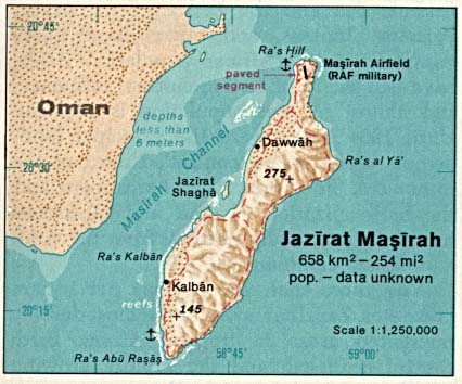
| Description |
English: Map of Masirah Island (Oman) in the Indian Ocean |
| Date | |
| Source | http://www.lib.utexas.edu/maps/islands_oceans_poles/jazirat_masirah.jpg |
| Author | Taken from Perry-Castañeda Library (PCL), originally from CIA Indian Ocean Atlas |
Licensing[edit]
| This image is a work of a Central Intelligence Agency employee, taken or made as part of that person's official duties. As a Work of the United States Government, this image or media is in the public domain in the United States.
|

|
File history
Click on a date/time to view the file as it appeared at that time.
| Date/Time | Thumbnail | Dimensions | User | Comment | |
|---|---|---|---|---|---|
| current | 11:42, 23 July 2009 | | 426 × 354 (37 KB) | Telim tor (talk | contribs) | == Information == {{Information |Description= {{en|Map of Mariah Island (Oman) in the Indian Ocean}} |Source=http://www.lib.utexas.edu/maps/islands_oceans_poles/jazirat_masirah.jpg |Date=1976 |Author=Taken from Perry-Castañeda Library (PCL), originally f |
You cannot overwrite this file.
File usage on Commons
The following page uses this file:
File usage on other wikis
The following other wikis use this file:
- Usage on ar.wikipedia.org
- Usage on arz.wikipedia.org
- Usage on az.wikipedia.org
- Usage on ca.wikipedia.org
- Usage on cs.wikipedia.org
- Usage on de.wikipedia.org
- Usage on en.wikipedia.org
- Usage on es.wikipedia.org
- Usage on eu.wikipedia.org
- Usage on fa.wikipedia.org
- Usage on fi.wikipedia.org
- Usage on gl.wikipedia.org
- Usage on id.wikipedia.org
- Usage on it.wikipedia.org
- Usage on nn.wikipedia.org
- Usage on pl.wikipedia.org
- Usage on ru.wikipedia.org
- Usage on tr.wikipedia.org
- Usage on uk.wikipedia.org
- Usage on ur.wikipedia.org
- Usage on www.wikidata.org
- Usage on zh.wikipedia.org