File:Map sahel 2.svg
Jump to navigation
Jump to search

Size of this PNG preview of this SVG file: 585 × 600 pixels. Other resolutions: 234 × 240 pixels | 468 × 480 pixels | 749 × 768 pixels | 999 × 1,024 pixels | 1,998 × 2,048 pixels | 1,200 × 1,230 pixels.
Original file (SVG file, nominally 1,200 × 1,230 pixels, file size: 37 KB)
Captions
Captions
Add a one-line explanation of what this file represents
Summary[edit]
| Description |
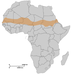
English: Map of Africa showing the Sahel highlighted in orange. |
| Date | |
| Source |
Own work English: created by myself based on the existing Sahel Map in jpg format using Blank Map-Africa.svg showing also borders of South Sudan.
Map was created using: |
| Author | |
| Other versions | Sahel Map (old jpg-Version) |
| SVG development | This map was created with an unknown SVG tool. |
Licensing[edit]

|
Permission is granted to copy, distribute and/or modify this document under the terms of the GNU Free Documentation License, Version 1.2 or any later version published by the Free Software Foundation; with no Invariant Sections, no Front-Cover Texts, and no Back-Cover Texts. A copy of the license is included in the section entitled GNU Free Documentation License. |
| This file is licensed under the Creative Commons Attribution-Share Alike 3.0 Unported license. | ||
| ||
| This licensing tag was added to this file as part of the GFDL licensing update. |
File history
Click on a date/time to view the file as it appeared at that time.
| Date/Time | Thumbnail | Dimensions | User | Comment | |
|---|---|---|---|---|---|
| current | 20:22, 12 January 2021 | | 1,200 × 1,230 (37 KB) | Mrmw (talk | contribs) | defaked |
| 23:33, 29 June 2014 |  | 1,200 × 1,230 (370 KB) | Pechristener (talk | contribs) | == {{int:filedesc}} == {{Information |Description = {{en|1=Map of Africa shwoing the Sahel highlighted in orange.}} |Source ={{own}} {{en|1=created by myself based on the existing Sahel Map in jpg format using [[:File... |
You cannot overwrite this file.
File usage on Commons
The following 3 pages use this file:
File usage on other wikis
The following other wikis use this file:
- Usage on ar.wikipedia.org
- Usage on arz.wikipedia.org
- Usage on ba.wikipedia.org
- Usage on ca.wikipedia.org
- Usage on da.wikipedia.org
- Usage on de.wikipedia.org
- Usage on de.wikinews.org
- Usage on de.wikivoyage.org
- Usage on de.wiktionary.org
- Usage on diq.wikipedia.org
- Usage on el.wikipedia.org
- Usage on en.wikipedia.org
- Usage on eo.wikipedia.org
- Usage on et.wikipedia.org
- Usage on fo.wikipedia.org
- Usage on frp.wikipedia.org
- Usage on frr.wikipedia.org
- Usage on fr.wikinews.org
- Usage on fr.wiktionary.org
- Usage on fy.wikipedia.org
- Usage on ga.wikipedia.org
- Usage on ha.wikipedia.org
- Usage on he.wikipedia.org
- Usage on hi.wikipedia.org
- Usage on hr.wikipedia.org
- Usage on id.wikipedia.org
- Usage on it.wikipedia.org
- Usage on it.wikivoyage.org
- Usage on nl.wikipedia.org
- Usage on pl.wikipedia.org
- Usage on ro.wikipedia.org
- Usage on rue.wikipedia.org
- Usage on ru.wikivoyage.org
- Usage on sg.wiktionary.org
- Usage on tl.wikipedia.org
- Usage on uk.wikipedia.org
- Usage on vec.wikipedia.org
- Usage on www.wikidata.org