File:Map of the national state delimitation of the republics of Central Asia (1924-1925).svg
Jump to navigation
Jump to search

Size of this PNG preview of this SVG file: 662 × 512 pixels. Other resolutions: 310 × 240 pixels | 621 × 480 pixels | 993 × 768 pixels | 1,280 × 990 pixels | 2,560 × 1,980 pixels.
Original file (SVG file, nominally 662 × 512 pixels, file size: 1.3 MB)
Captions
Captions
Add a one-line explanation of what this file represents
Summary[edit]
.svg&action=edit§ion=1)
| Description |
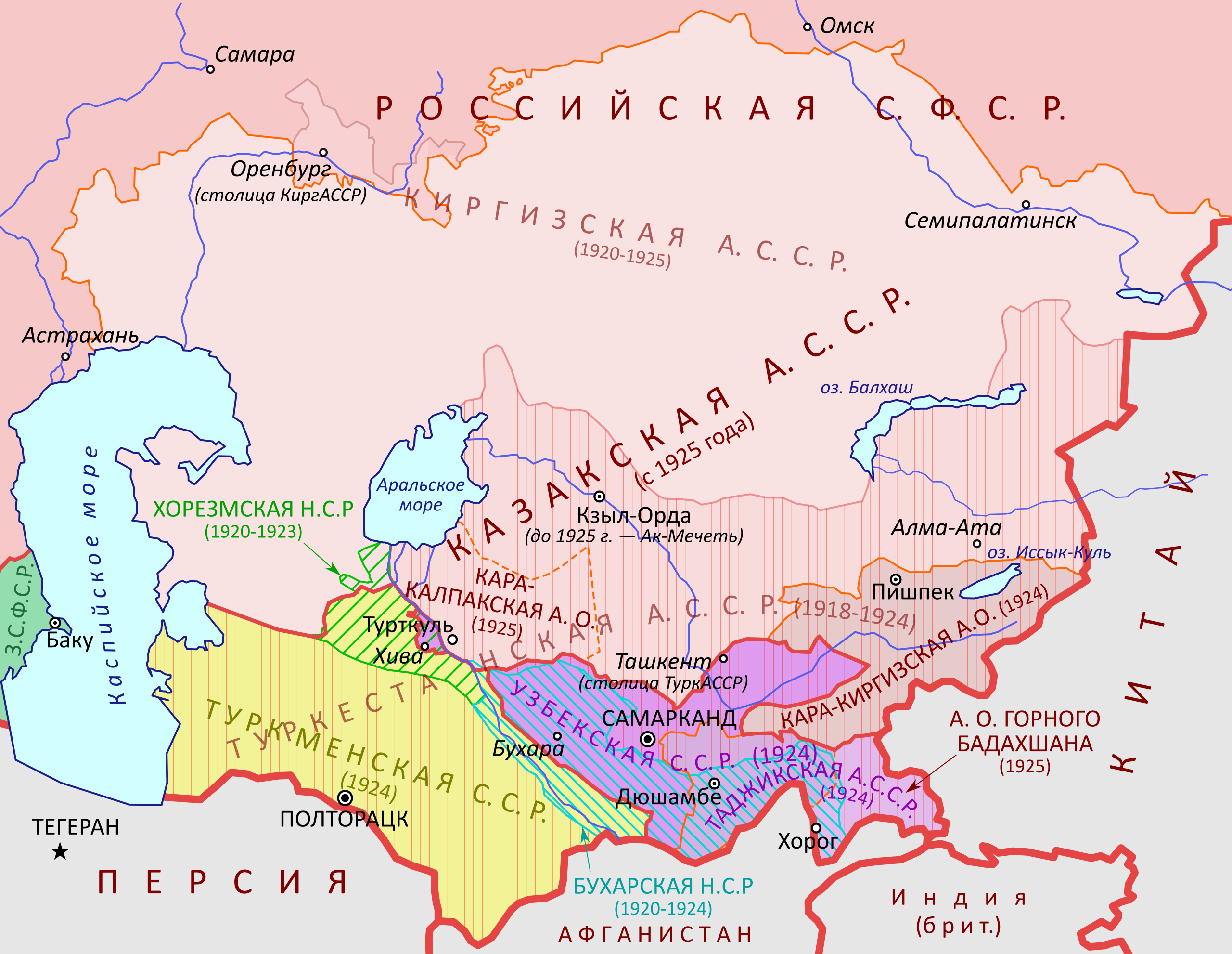
Русский: Карта национального размежевания в Средней Азии в 1924-1925 годах.
English: Map of the national state delimitation of the republics of Central Asia (1924-1925). |
| Date | |
| Source | Own work, based on [1] |
| Author | Hellerick |
![[1]](http://minchanin.esmasoft.com/maps/hist1970/hist10-11.jpg)
Licensing[edit]
.svg&action=edit§ion=2)
I, the copyright holder of this work, hereby publish it under the following license:
This file is licensed under the Creative Commons Attribution-Share Alike 4.0 International license.
- You are free:
- to share – to copy, distribute and transmit the work
- to remix – to adapt the work
- Under the following conditions:
- attribution – You must give appropriate credit, provide a link to the license, and indicate if changes were made. You may do so in any reasonable manner, but not in any way that suggests the licensor endorses you or your use.
- share alike – If you remix, transform, or build upon the material, you must distribute your contributions under the same or compatible license as the original.
File history
Click on a date/time to view the file as it appeared at that time.
| Date/Time | Thumbnail | Dimensions | User | Comment | |
|---|---|---|---|---|---|
| current | 14:25, 3 August 2019 | | 662 × 512 (1.3 MB) | Hellerick (talk | contribs) | More precize borders for Chelyabinsk/Kazakhstan and Tajikistan/Uzbekistan. |
| 09:42, 2 August 2019 |  | 662 × 512 (1.27 MB) | Hellerick (talk | contribs) | Smaller font size for the Kirgiz ASSR. | |
| 06:26, 2 August 2019 |  | 662 × 512 (1.27 MB) | Hellerick (talk | contribs) | Many minor changes. | |
| 16:45, 1 August 2019 |  | 662 × 512 (1.19 MB) | Hellerick (talk | contribs) | Too many changes. | |
| 05:45, 1 August 2019 |  | 662 × 449 (1.05 MB) | Hellerick (talk | contribs) | Russian RSFSR > Russian SFSR; Ashkhabad > Poltoratsk; INDIA > India (Brit.) | |
| 05:51, 31 July 2019 |  | 662 × 449 (1.04 MB) | Hellerick (talk | contribs) | Corrected the Orenburg section of the Kazakh border, added Kzyl-Orda, added the Volga, minor changes. | |
| 13:57, 25 July 2019 |  | 662 × 449 (1,008 KB) | Hellerick (talk | contribs) | Weird Viewbox bug | |
| 13:42, 25 July 2019 |  | 620 × 421 (992 KB) | Hellerick (talk | contribs) | User created page with UploadWizard |
You cannot overwrite this file.
File usage on Commons
The following 2 pages use this file:
File usage on other wikis
The following other wikis use this file:
- Usage on it.wikipedia.org
- Usage on kk.wikipedia.org
- Usage on lv.wikipedia.org
- Usage on ru.wikipedia.org
.svg&oldid=658568645)