Category:Maps of the history of Tajikistan
Jump to navigation
Jump to search
Subcategories
This category has the following 15 subcategories, out of 15 total.
- Old maps of Tajikistan (3 F)
B
C
- Maps of the Chagatai Khanate (22 F)
G
- Maps of the Ghaznavid Empire (31 F)
H
- Maps of the Hephthalites (16 F)
K
- Maps of the Kara-Khanids (8 F)
- Maps of the Khwarazmian Empire (18 F)
M
S
- Maps of the Samanid Empire (19 F)
T
- Maps of the Timurid Empire (104 F)
Media in category "Maps of the history of Tajikistan"
The following 31 files are in this category, out of 31 total.
-
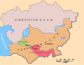
 AlashOrda1920.png 1,200 × 978; 70 KB
-
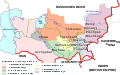
 ApproximatebordersAlashAutonomy.png 1,400 × 1,108; 90 KB
-
 Asia 1200ad.jpg 1,968 × 1,215; 731 KB
-
 Asia Centrala - Expansion russa de 1725 a 1914.png 2,148 × 1,536; 664 KB
-
 Asia Centrala Sovietica en 1936.png 1,345 × 952; 263 KB
-

-
 Central Asia 1900 mk.svg 658 × 536; 125 KB
-
 Central Asia 1900-en.svg 658 × 536; 154 KB
-
 Central Asia 1900-es.svg 658 × 536; 120 KB
-
 Central Asia 1900-ko.svg 658 × 536; 159 KB
-
 Central Asia 1900-nl.svg 670 × 541; 109 KB
-
 Central Asia 1900-ru.svg 658 × 536; 140 KB
-

-

-
 National delimitation in Middle Asia.jpg 1,451 × 975; 568 KB
-
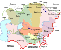
 SovietCentralAsia 1922-hu.svg 1,123 × 866; 81 KB
-
 SovietCentralAsia1922-es.svg 2,597 × 2,000; 165 KB
-
 SovietCentralAsia1922.svg 1,123 × 866; 207 KB
-
 SovietCentralAsia1922ru.svg 1,066 × 869; 241 KB
-
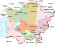
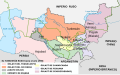
 Turkestan 1900-de.svg 643 × 400; 95 KB
-
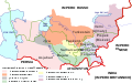
 Turkestan 1900-en.svg 643 × 400; 111 KB
-
 Turkestan 1900-es.svg 2,393 × 1,485; 374 KB
-
 Turkestan 1900-it.svg 643 × 400; 93 KB
-
 Turkestan 1900-ko.svg 643 × 400; 148 KB
-
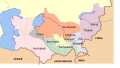 Turkestan 1900-nl.svg 643 × 364; 62 KB
-
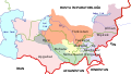
 Turkestan 1900-ru.svg 643 × 400; 112 KB
-
 Türkistan 1900-tr.svg 643 × 364; 79 KB
-
 Zunghar Khanate at 1760.jpg 495 × 553; 99 KB
-
 Казахстан в границах Российской Империи.png 672 × 404; 38 KB
-
 Осорхонаҳои Тоҷикистон 42.jpg 1,728 × 1,296; 971 KB
-
 Туркестан 1900.svg 643 × 364; 83 KB


_-_not_so_busy.svg)
.svg)


