File:Map of the United States of America with the British Possessions of Canada, Nova Scotia, New Brunswick and Newfoundland Divided with the French, also the Spanish Territories of Louisiana and Florida According to t(...) - NARA - 2450016.jpg
Jump to navigation
Jump to search
Size of this preview: 798 × 600 pixels. Other resolutions: 320 × 240 pixels | 639 × 480 pixels | 945 × 710 pixels.
Original file (945 × 710 pixels, file size: 210 KB, MIME type: image/jpeg)
Captions
Captions
Add a one-line explanation of what this file represents
Summary[edit]
_-_NARA_-_2450016.jpg&action=edit§ion=1)
| Author |
Unknown author or not provided |
||||||||||||||||||||||||||
| Record creator | Arbitration by the King of the Netherlands under Terms of the Convention of September 29, 1827, between the United States and Great Britain. 9/29/1827-1/12/1831 | ||||||||||||||||||||||||||
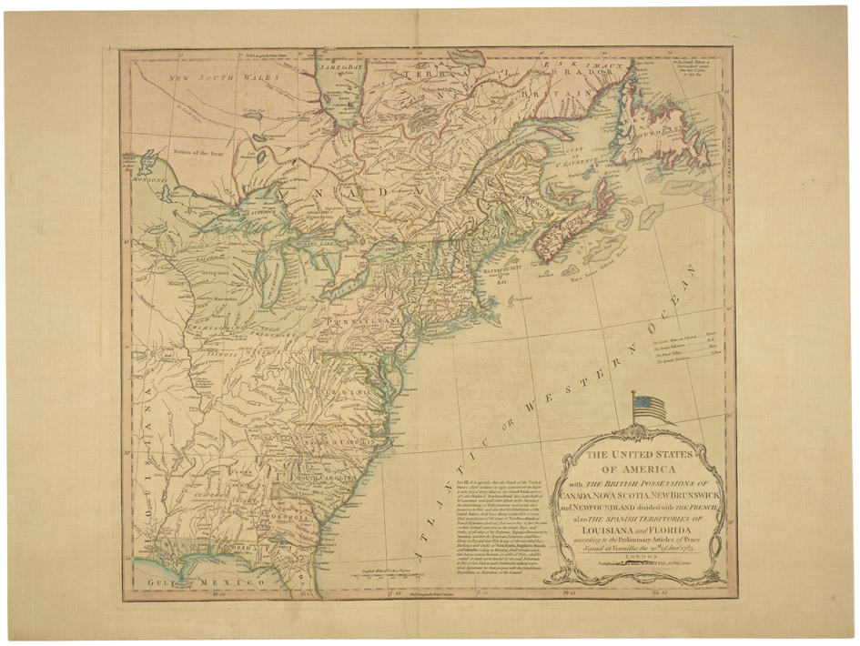
| Title |
Map of the United States of America with the British Possessions of Canada, Nova Scotia, New Brunswick and Newfoundland Divided with the French, also the Spanish Territories of Louisiana and Florida According to the Preliminary Articles of Peace Signed at Versailles the 20th of January 1783 |
||||||||||||||||||||||||||
| Date | 1800 | ||||||||||||||||||||||||||
| Collection |
|
||||||||||||||||||||||||||
| Record ID |
|
||||||||||||||||||||||||||
| Source | U.S. National Archives and Records Administration | ||||||||||||||||||||||||||
| Other versions |
Please do not overwrite this file: any restoration work should be uploaded with a new name and linked in this page's "other versions=" parameter, so that this file represents the exact file found in the NARA catalog record to which it links. The metadata on this page was imported directly from NARA's catalog record; additional descriptive text may be added by Wikimedians to the template below with the "description=" parameter, but please do not modify the other fields. |
||||||||||||||||||||||||||
Licensing[edit]
_-_NARA_-_2450016.jpg&action=edit§ion=2)
This file was provided to Wikimedia Commons by the National Archives and Records Administration as part of a cooperation project. The National Archives and Records Administration provides images depicting American and global history which are public domain or licensed under a free license.
|
This work is in the public domain in the United States because it is a work prepared by an officer or employee of the United States Government as part of that person’s official duties under the terms of Title 17, Chapter 1, Section 105 of the US Code.
Note: This only applies to original works of the Federal Government and not to the work of any individual U.S. state, territory, commonwealth, county, municipality, or any other subdivision. This template also does not apply to postage stamp designs published by the United States Postal Service since 1978. (See § 313.6(C)(1) of Compendium of U.S. Copyright Office Practices). It also does not apply to certain US coins; see The US Mint Terms of Use.
|
 | |
| This file has been identified as being free of known restrictions under copyright law, including all related and neighboring rights. | ||
File history
Click on a date/time to view the file as it appeared at that time.
| Date/Time | Thumbnail | Dimensions | User | Comment | |
|---|---|---|---|---|---|
| current | 19:39, 21 October 2018 | | 945 × 710 (210 KB) | US National Archives bot (talk | contribs) | Bot-assisted upload of US National Archives Identifer 2450016. |
You cannot overwrite this file.
File usage on Commons
The following page uses this file:
_-_NARA_-_2450016.jpg)
_-_NARA_-_2450016.jpg&oldid=793409795)