File:Map of the Krasnoyarsk Krai.png
Original file (1,545 × 1,802 pixels, file size: 303 KB, MIME type: image/png)
Captions
Captions
Summary[edit]
| Description |
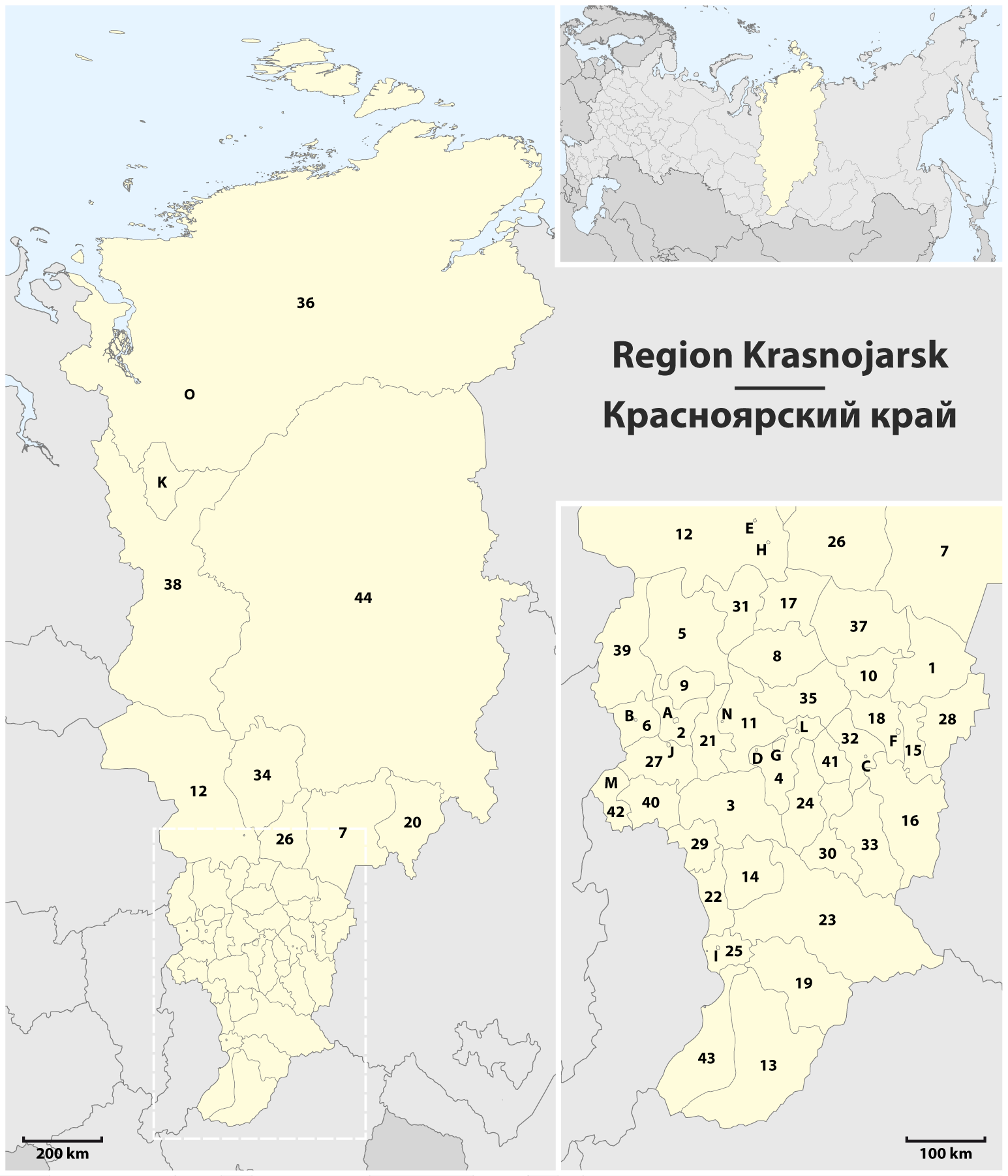
Deutsch: Karte der Region Krasnojarsk
English: Map of the Krasnoyarsk Krai
1 Aban • Абанский |
| Date | |
| Source | Own work, using this file by Uwe Dedering for the orientation map |
| Author | Maximilian Dörrbecker (Chumwa) |
| Permission (Reusing this file) |
I, the copyright holder of this work, hereby publish it under the following license: This file is licensed under the Creative Commons Attribution-Share Alike 2.5 Generic license.
|
| Other versions |
Derivative works of this file: Map of the Krasnoyarsk Krai - 2.png |

.png)


File history
Click on a date/time to view the file as it appeared at that time.
| Date/Time | Thumbnail | Dimensions | User | Comment | |
|---|---|---|---|---|---|
| current | 12:40, 23 December 2014 | | 1,545 × 1,802 (303 KB) | Kaganer (talk | contribs) | Added "O" - Norilsk |
| 06:46, 3 April 2010 |  | 1,545 × 1,802 (390 KB) | Chumwa (talk | contribs) | Farbanpassung in Orientierungskarte | |
| 22:28, 2 April 2010 |  | 1,545 × 1,802 (390 KB) | Chumwa (talk | contribs) | == {{int:filedesc}} == {{Information |Description= {{de|Karte der Region Krasnojarsk}} {{en|Map of the Krasnoyarsk Krai}} |Author=Maximilian Dörrbecker (Chumwa) |Source={{Own}}, using [[:File:Russia edcp location m |
You cannot overwrite this file.
File usage on Commons
The following 9 pages use this file:
- User:Chumwa/Gallery
- File:Krasnojarski-krai-numbered.png
- File:Krasnojarski-krai-south-numbered.png
- File:Krasnojarski-krai-south.png
- File:Krasnojarski-krai.png
- File:Map of the Krasnoyarsk Krai.png
- File:Map of the Krasnoyarsk Krai (upright).png
- File:Map of the Krasnoyarsk Krai (with index).png
- File:Map of the Krasnoyarsk Krai - 2.png
.png)
File usage on other wikis
The following other wikis use this file:
- Usage on ba.wikipedia.org
- Usage on de.wikipedia.org
- Usage on es.wikipedia.org
- Usage on fr.wikipedia.org
- Usage on nl.wikipedia.org
- Usage on sr.wikipedia.org
- Usage on tt.wikipedia.org