File:Map of the Christian world around the mediterranean in the 5th century AD.png
Jump to navigation
Jump to search

Size of this preview: 800 × 468 pixels. Other resolutions: 320 × 187 pixels | 640 × 374 pixels | 1,117 × 653 pixels.
Original file (1,117 × 653 pixels, file size: 206 KB, MIME type: image/png)
Captions
Captions
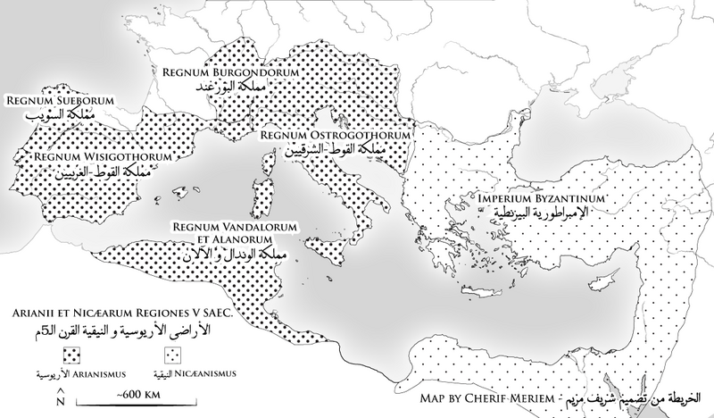
Map of the Christian world around the mediterranean in the 5th century AD (CE)
Summary[edit]
| Description |
Français : La carte met en valeur le monde nicéen et le monde arien.
English: The map shows the arian and nicene world of the 5th century.
العربية: تبرز الخريطة العالمين الأريوسي و النيقي من القرن الـ5م
جازايرية: توْري هاذ الكارطة البلدان تاع النصارى لي يوحدوا و لي يآمنوا بالتثليث |
| Date | |
| Source | Own work |
| Author | Cherif Meriam |
Licensing[edit]
I, the copyright holder of this work, hereby publish it under the following license:
This file is licensed under the Creative Commons Attribution-Share Alike 4.0 International license.
- You are free:
- to share – to copy, distribute and transmit the work
- to remix – to adapt the work
- Under the following conditions:
- attribution – You must give appropriate credit, provide a link to the license, and indicate if changes were made. You may do so in any reasonable manner, but not in any way that suggests the licensor endorses you or your use.
- share alike – If you remix, transform, or build upon the material, you must distribute your contributions under the same or compatible license as the original.
File history
Click on a date/time to view the file as it appeared at that time.
| Date/Time | Thumbnail | Dimensions | User | Comment | |
|---|---|---|---|---|---|
| current | 14:56, 4 June 2021 | | 1,117 × 653 (206 KB) | Slifer621 (talk | contribs) | Uploaded own work with UploadWizard |
You cannot overwrite this file.
File usage on Commons
The following 2 pages use this file: