File:Map of Rutherford County, Tenn. - from actual surveys LOC 2012586255.jpg
Jump to navigation
Jump to search

Size of this preview: 430 × 600 pixels. Other resolutions: 172 × 240 pixels | 344 × 480 pixels | 551 × 768 pixels | 734 × 1,024 pixels | 1,469 × 2,048 pixels | 11,913 × 16,611 pixels.
Original file (11,913 × 16,611 pixels, file size: 25.45 MB, MIME type: image/jpeg)
Captions
Captions
Add a one-line explanation of what this file represents
Summary[edit]
| Warning | The original file is very high-resolution. It might not load properly or could cause your browser to freeze when opened at full size. |
|---|
| Description |
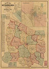
English: Relief shown by hachures. Shows roads, railroads, property tract lines, tract numbers, and landowners' names. Includes business directories, insets of Milton, Eagleville, Fosterville, Smyrna, City of Murfreesboro, and Christiana, list of names, and table of population. LC Land ownership maps, 878 Available also through the Library of Congress Web site as a raster image. |
||
| Title | Map of Rutherford County, Tenn. : from actual surveys | ||
| Shelf ID | G3963.R8 1878 .D2 | ||
| Date | |||
| Source | https://www.loc.gov/item/2012586255/ | ||
| Author | D.G. Beers & Co.; Beers, D. G. (Daniel G.); Lanagan, J.; Worley & Bracher | ||
| Permission (Reusing this file) |
|
||
| Other versions |
|
||
| Location | Rutherford County · United States · Tennessee | ||
| Part of | American Memory · Catalog · County Landownership Maps · Geography And Map Division · Cultural Landscapes | ||
| Subject | Cadastral Maps · Rutherford County · Rutherford County (Tenn.) · United States · Maps · Tennessee · Real Property · Landowners |


Licensing[edit]
|
This is a faithful photographic reproduction of a two-dimensional, public domain work of art. The work of art itself is in the public domain for the following reason:
The official position taken by the Wikimedia Foundation is that "faithful reproductions of two-dimensional public domain works of art are public domain".
This photographic reproduction is therefore also considered to be in the public domain in the United States. In other jurisdictions, re-use of this content may be restricted; see Reuse of PD-Art photographs for details. | ||||
File history
Click on a date/time to view the file as it appeared at that time.
| Date/Time | Thumbnail | Dimensions | User | Comment | |
|---|---|---|---|---|---|
| current | 14:02, 21 July 2018 | | 11,913 × 16,611 (25.45 MB) | Fæ (talk | contribs) | LOC Maps https://www.loc.gov/item/2012586255/ #7059 |
You cannot overwrite this file.
File usage on Commons
The following page uses this file: