File:Map of New York and vicinity. LOC 2015591056.tif
Jump to navigation
Jump to search

Size of this JPG preview of this TIF file: 373 × 600 pixels. Other resolutions: 149 × 240 pixels | 298 × 480 pixels | 477 × 768 pixels | 636 × 1,024 pixels | 1,273 × 2,048 pixels | 7,068 × 11,369 pixels.
Original file (7,068 × 11,369 pixels, file size: 229.9 MB, MIME type: image/tiff)
Captions
Captions
Add a one-line explanation of what this file represents
Summary[edit]
| Warning | The original file is very high-resolution. It might not load properly or could cause your browser to freeze when opened at full size. |
|---|
| Description |
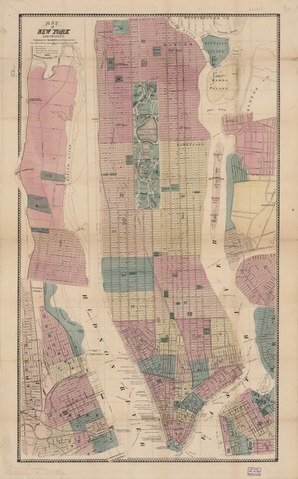
English: The principal map covers New York City (Manhattan) south of 135th Street; the inset covers it from there northward to the Harlem River at Westchester County; also covers Jersey City (N.J.) and adjacent municipalities. Shows Lower Manhattan river piers (numbered) and names of their proprietary companies. Hand colored to distinguish city ward areas (numbered) in New York City and Jersey City. "Entered according to act of Congress in the year 1865 by M. Dripps in the Clerks Office of the District Court for the Southern District of New York." LC copy imperfect: Cover removed, missing. Includes inset of northern Manhattan. Signed in lead-pencil script on verso: Millard Fillmore, at New York Oct. 5, 1868. Available also through the Library of Congress Web site as a raster image. |
||
| Title | Map of New York and vicinity. | ||
| Shelf ID | G3804.N4 1867 .D7 | ||
| Date | |||
| Source | https://www.loc.gov/item/2015591056/ | ||
| Author | Dripps, M. (Matthew) | ||
| Permission (Reusing this file) |
|
||
| Other versions |
|
||
| Location | Jersey City. · Jersey City · New Jersey · New York City · United States · New York · New York. · New York (State) | ||
| Part of | American Memory · Cities And Towns · Catalog · Geography And Map Division · General Maps | ||
| Subject | Jersey City · New Jersey · New York (N.Y.) · United States · Maps · New York · Administrative And Political Divisions · Jersey City (N.J.) · New York (State) · Piers |


Licensing[edit]
|
This is a faithful photographic reproduction of a two-dimensional, public domain work of art. The work of art itself is in the public domain for the following reason:
The official position taken by the Wikimedia Foundation is that "faithful reproductions of two-dimensional public domain works of art are public domain".
This photographic reproduction is therefore also considered to be in the public domain in the United States. In other jurisdictions, re-use of this content may be restricted; see Reuse of PD-Art photographs for details. | ||||
File history
Click on a date/time to view the file as it appeared at that time.
| Date/Time | Thumbnail | Dimensions | User | Comment | |
|---|---|---|---|---|---|
| current | 17:57, 4 June 2018 |  | 7,068 × 11,369 (229.9 MB) | Fæ (talk | contribs) | LOC Maps https://www.loc.gov/item/2015591056/ #4798 |
You cannot overwrite this file.
File usage on Commons
The following page uses this file: