File:Map exhibiting the position of the several lines connected with the settlement of the Ohio boundary question. LOC 75690625.tif
Jump to navigation
Jump to search

Size of this JPG preview of this TIF file: 800 × 455 pixels. Other resolutions: 320 × 182 pixels | 640 × 364 pixels | 1,024 × 583 pixels | 1,280 × 729 pixels | 2,560 × 1,457 pixels | 7,897 × 4,496 pixels.
Original file (7,897 × 4,496 pixels, file size: 101.58 MB, MIME type: image/tiff)
Captions
Captions
Add a one-line explanation of what this file represents
Summary[edit]
| Description |
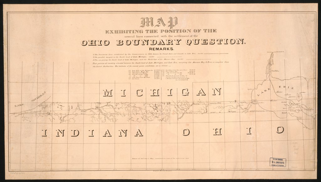
English: Scale 1:625,000. Originally accompanied a report of Capt. Andrew Talcott, Dec. 14, 1835, concerning the Ohio boundary. Also shows boundaries between Ohio, Michigan, Indiana, and Ontario. Includes text. Available also through the Library of Congress Web site as a raster image. |
||
| Title | Map exhibiting the position of the several lines connected with the settlement of the Ohio boundary question. | ||
| Shelf ID | G4081.F7 1835 .H61 | ||
| Date | |||
| Source | https://www.loc.gov/item/75690625/ | ||
| Author | Talcott, Andrew; [Hood, Washington]; Haas, P. | ||
| Permission (Reusing this file) |
|
||
| Other versions |
|
||
| Location | United States · Ohio · Michigan · Ohio. · Michigan. | ||
| Part of | American Memory · Catalog · Geography And Map Division · Cultural Landscapes | ||
| Subject | Boundaries · Ohio · Michigan · United States · Maps |


Licensing[edit]
|
This is a faithful photographic reproduction of a two-dimensional, public domain work of art. The work of art itself is in the public domain for the following reason:
The official position taken by the Wikimedia Foundation is that "faithful reproductions of two-dimensional public domain works of art are public domain".
This photographic reproduction is therefore also considered to be in the public domain in the United States. In other jurisdictions, re-use of this content may be restricted; see Reuse of PD-Art photographs for details. | ||||
File history
Click on a date/time to view the file as it appeared at that time.
| Date/Time | Thumbnail | Dimensions | User | Comment | |
|---|---|---|---|---|---|
| current | 04:08, 7 January 2020 |  | 7,897 × 4,496 (101.58 MB) | Fæ (talk | contribs) | LOC Maps https://www.loc.gov/item/75690625/ #1690 |
You cannot overwrite this file.
File usage on Commons
The following page uses this file: