File:Manhattanhenge satellite view.svg
Jump to navigation
Jump to search

Size of this PNG preview of this SVG file: 400 × 600 pixels. Other resolutions: 160 × 240 pixels | 320 × 480 pixels | 512 × 768 pixels | 682 × 1,024 pixels | 1,365 × 2,048 pixels.
Original file (SVG file, nominally 512 × 768 pixels, file size: 67 KB)
Captions
Captions
Add a one-line explanation of what this file represents

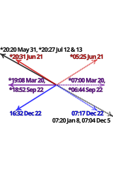
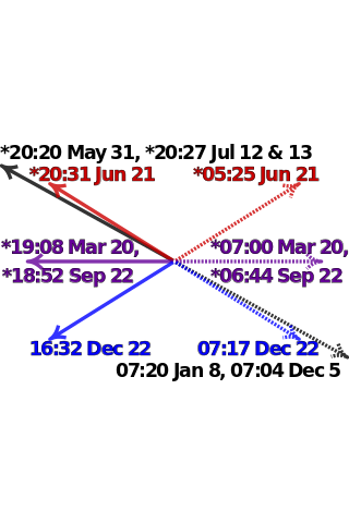
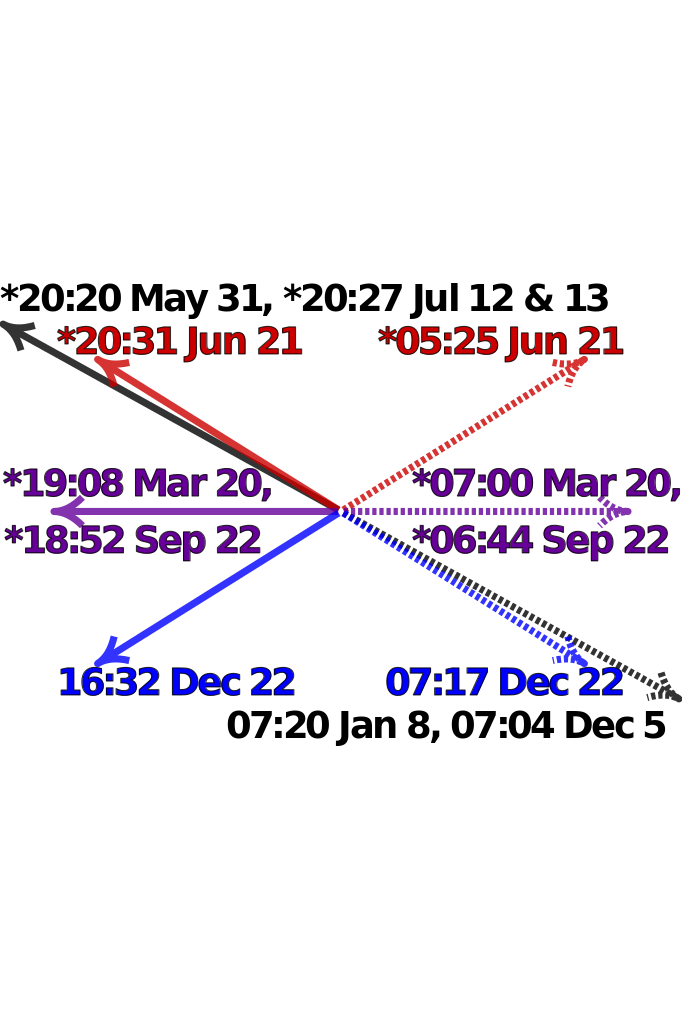
| Description | Satellite image of Manhattan, New York City centered on the intersection of Park Avenue and 34th Street, with directions and local times of sunrises (dotted lines) and sunsets (solid lines) on Manhattanhenge (black), summer solstice (red), equinoxes (purple) and winter solstice (blue) in 2011. Times marked with "*" have been adjusted for daylight saving. Data from http://www.esrl.noaa.gov/gmd/grad/solcalc/ and bitmap from http://earthobservatory.nasa.gov/IOTD/view.php?id=3678 and created by NASA. | |
| Date | (UTC) | |
| Source |
|
|
| Author |
|

W3C-validity not checked.

|
This SVG file contains embedded text that can be translated into your language, using any capable SVG editor, text editor or the SVG Translate tool. For more information see: About translating SVG files. |
| This is a retouched picture, which means that it has been digitally altered from its original version. Modifications: Update to 2012 and reduce clutter. The original can be viewed here: Manhattanhenge map.svg:
|
I, the copyright holder of this work, hereby publish it under the following license:
This file is licensed under the Creative Commons Attribution-Share Alike 3.0 Unported license.
- You are free:
- to share – to copy, distribute and transmit the work
- to remix – to adapt the work
- Under the following conditions:
- attribution – You must give appropriate credit, provide a link to the license, and indicate if changes were made. You may do so in any reasonable manner, but not in any way that suggests the licensor endorses you or your use.
- share alike – If you remix, transform, or build upon the material, you must distribute your contributions under the same or compatible license as the original.
Original upload log[edit]
This image is a derivative work of the following images:
- File:Manhattanhenge_map.svg licensed with Cc-by-sa-3.0
- 2011-07-18T23:55:44Z Cmglee 512x768 (71587 Bytes) Fix text.
- 2011-07-18T23:47:00Z Cmglee 512x768 (71599 Bytes) {{Information |Description=Map of Manhattan, New York City centered on the intersection of Park Avenue and 34th Street, with times and directions of sunrises (dotted line) and sunsets (solid line) in 2011. Times marked with "
Uploaded with derivativeFX
File history
Click on a date/time to view the file as it appeared at that time.
| Date/Time | Thumbnail | Dimensions | User | Comment | |
|---|---|---|---|---|---|
| current | 00:48, 30 July 2011 | | 512 × 768 (67 KB) | Cmglee (talk | contribs) | Bold text and arrows. |
| 00:39, 30 July 2011 |  | 512 × 768 (67 KB) | Cmglee (talk | contribs) | Shrink text. | |
| 00:38, 30 July 2011 |  | 512 × 768 (67 KB) | Cmglee (talk | contribs) | Use 2011 dates, darken purple text and enlarge text. | |
| 04:38, 28 July 2011 |  | 512 × 768 (67 KB) | Cmglee (talk | contribs) | {{Information |Description=Satellite image of Manhattan, New York City centered on the intersection of Park Avenue and 34th Street, with directions and local times of sunrises (dotted lines) and sunsets (solid lines) on Manhattanhenge (black), summer sols |
You cannot overwrite this file.
File usage on Commons
The following 4 pages use this file:
File usage on other wikis
The following other wikis use this file:
- Usage on en.wikipedia.org
- Usage on es.wikipedia.org
- Usage on fa.wikipedia.org
- Usage on id.wikipedia.org
- Usage on it.wikipedia.org
- Usage on ja.wikipedia.org
- Usage on ko.wikipedia.org
- Usage on ms.wikipedia.org
- Usage on pt.wikipedia.org
- Usage on ro.wikipedia.org
- Usage on www.wikidata.org
- Usage on zh.wikipedia.org