File:Malheurmap.pdf
Jump to navigation
Jump to search

Size of this JPG preview of this PDF file: 564 × 599 pixels. Other resolutions: 226 × 240 pixels | 452 × 480 pixels | 723 × 768 pixels | 1,200 × 1,275 pixels.
Original file (1,200 × 1,275 pixels, file size: 359 KB, MIME type: application/pdf)
Captions
Captions
Add a one-line explanation of what this file represents
Summary[edit]
| Description |
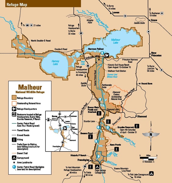
English: Map of Malheur National Wildlife Refuge 30 miles/48 km south of Burns, located in Harney County, Oregon, USA, managed by the U.S. Fish and Wildlife Service |
| Date | |
| Source |
Originally appeared in a 13-page brochure published by the Fish & Wildlife Service located here: http://www.fws.gov/uploadedFiles/Region_1/NWRS/Zone_2/Malheur/Documents/malheur_brochure.pdf (maps page) |
| Author | US Fish & Wildlife Service |
| Permission (Reusing this file) |
PD-USGov-FWS |
43°15′57″N 118°50′39″W / 43.26583°N 118.84417°W
Licensing[edit]
This image or recording is the work of a U.S. Fish and Wildlife Service employee, taken or made as part of that person's official duties. As a work of the U.S. federal government, the image is in the public domain. For more information, see the Fish and Wildlife Service copyright policy.
|
 |
File history
Click on a date/time to view the file as it appeared at that time.
| Date/Time | Thumbnail | Dimensions | User | Comment | |
|---|---|---|---|---|---|
| current | 06:50, 8 January 2016 |  | 1,200 × 1,275 (359 KB) | RangerRichard (talk | contribs) | User created page with UploadWizard |
You cannot overwrite this file.
File usage on Commons
The following 2 pages use this file:
File usage on other wikis
The following other wikis use this file:
- Usage on ca.wikipedia.org
- Usage on de.wikipedia.org
- Usage on fr.wikipedia.org
- Usage on www.wikidata.org