File:MAP OF MARYLAND JESUIT STATIONS, 17TH-19TH CENTURIES.pdf
Jump to navigation
Jump to search

Size of this JPG preview of this PDF file: 369 × 599 pixels. Other resolutions: 148 × 240 pixels | 295 × 480 pixels | 473 × 768 pixels | 1,156 × 1,877 pixels.
Original file (1,156 × 1,877 pixels, file size: 192 KB, MIME type: application/pdf)
Captions
Captions
Add a one-line explanation of what this file represents
Summary[edit]
| Description |
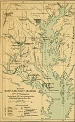
English: A map of Jesuit stations in Maryland from the 17th to the 19th centuries, showing the locations of Jesuit plantations, farms, and schools, including Bohemia, Frederick, Georgetown, Leonardtown, Newtown, Port Tobacco, St. Inigoes, St. Joseph, St. Thomas, Washington, White Marsh, and Woodstock. |
| Date | |
| Source | Georgetown Slavery Archive https://slaveryarchive.georgetown.edu/items/show/57 |
| Author | Georgetown Slavery Archive |
| Other versions |
.jpg)
Licensing[edit]
This work is in the public domain in the United States because it was published (or registered with the U.S. Copyright Office) before January 1, 1929.
Public domain works must be out of copyright in both the United States and in the source country of the work in order to be hosted on the Commons. If the work is not a U.S. work, the file must have an additional copyright tag indicating the copyright status in the source country.
Note: This tag should not be used for sound recordings. |
File history
Click on a date/time to view the file as it appeared at that time.
| Date/Time | Thumbnail | Dimensions | User | Comment | |
|---|---|---|---|---|---|
| current | 23:15, 2 February 2018 |  | 1,156 × 1,877 (192 KB) | Lhblossom1936 (talk | contribs) | User created page with UploadWizard |
You cannot overwrite this file.
File usage on Commons
The following page uses this file: