File:Lorraine geologic map.svg
Jump to navigation
Jump to search

Size of this PNG preview of this SVG file: 600 × 600 pixels. Other resolutions: 240 × 240 pixels | 480 × 480 pixels | 768 × 768 pixels | 1,024 × 1,024 pixels | 2,048 × 2,048 pixels | 1,300 × 1,300 pixels.
Original file (SVG file, nominally 1,300 × 1,300 pixels, file size: 358 KB)
Captions
Captions
Add a one-line explanation of what this file represents
Summary[edit]
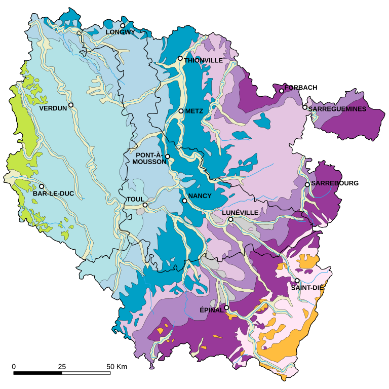
| KEY | |
|---|---|
| English | Français |
Recent alluvium
Ancient alluvium
Cretaceous
Upper Jurassic
Middle Jurassic
Lower Jurassic
Upper Triassic
Middle Triassic
Lower Triassic
Hercynian granites
Paleozoic and earlier
|
Alluvions récentes
Alluvions anciennes
Crétacé
Jurassique supérieur
Jurassique moyen
Jurassique inférieur
Trias supérieur
Trias moyen
Trias inférieur
Granites hercyniens
Paléozoïque et antérieur
|
| Description |
English: Geologic map of the Lorraine region in France.
Français : Carte géologique de la Lorraine France. |
||
| Date | |||
| Source | Based upon the map from the university of Nancy-Metz | ||
| Author | Eric Gaba (Sting - fr:Sting) | ||
| Permission (Reusing this file) |
|
Licensing[edit]
I, the copyright holder of this work, hereby publish it under the following license:
This file is licensed under the Creative Commons Attribution-Share Alike 2.5 Generic license.
- You are free:
- to share – to copy, distribute and transmit the work
- to remix – to adapt the work
- Under the following conditions:
- attribution – You must give appropriate credit, provide a link to the license, and indicate if changes were made. You may do so in any reasonable manner, but not in any way that suggests the licensor endorses you or your use.
- share alike – If you remix, transform, or build upon the material, you must distribute your contributions under the same or compatible license as the original.
File history
Click on a date/time to view the file as it appeared at that time.
| Date/Time | Thumbnail | Dimensions | User | Comment | |
|---|---|---|---|---|---|
| current | 16:24, 8 December 2013 | | 1,300 × 1,300 (358 KB) | JuJu939 (talk | contribs) | Ajout Thionville + Sarreguemines |
| 10:53, 22 December 2010 |  | 1,300 × 1,300 (356 KB) | Ciaurlec (talk | contribs) | Changed some colours to the ones of geological palette as purposed in fr.graphic lab | |
| 23:34, 23 September 2006 |  | 1,300 × 1,300 (356 KB) | Sting (talk | contribs) | Accents; + scale | |
| 05:21, 21 September 2006 |  | 1,300 × 1,300 (353 KB) | Sting (talk | contribs) | Bug correction | |
| 05:18, 21 September 2006 |  | 1,300 × 1,300 (354 KB) | Sting (talk | contribs) | {{Information |Description=Geologic map of the Lorraine region in France |Source=Based upon the [http://www3.ac-nancy-metz.fr/base-geol/index.php map] from the university of Nancy-Metz |Date=September 2006 |Author=Eric Gaba (Sting) |Permiss |
You cannot overwrite this file.
File usage on Commons
The following 2 pages use this file:
File usage on other wikis
The following other wikis use this file:
- Usage on da.wikipedia.org
- Usage on de.wikipedia.org
- Usage on el.wikipedia.org
- Usage on es.wikipedia.org
- Usage on fr.wikipedia.org
- Lorraine
- Discussion:Lorraine
- Géographie de la Lorraine
- Verdun
- Bar-le-Duc
- Commercy
- Tromborn
- Portail:Lorraine/Photographie-1126
- Portail:Lorraine/Photographie-11
- Cartographie des corridors biologiques
- Côtes de Meuse
- Côtes de Moselle
- Wikipédia:Atelier graphique/Images à améliorer/Archives/Mars 2007
- Utilisateur:Alfr/Draft
- Projet:Cartographie/Cartes standards/France
- Historique du projet du lac de Noirgueux
- Wikipédia:Atelier graphique/Cartes/Archives/mai 2017
- Utilisateur:Johan Wecker/Brouillon
- Usage on lb.wikipedia.org
- Usage on www.wikidata.org