File:London Underground Overground DLR Crossrail map night.pdf
Jump to navigation
Jump to search

Size of this JPG preview of this PDF file: 800 × 422 pixels. Other resolutions: 320 × 169 pixels | 640 × 338 pixels | 1,024 × 541 pixels | 1,280 × 676 pixels | 2,560 × 1,352 pixels | 5,208 × 2,750 pixels.
Original file (5,208 × 2,750 pixels, file size: 113 KB, MIME type: application/pdf)
Captions
Captions
Add a one-line explanation of what this file represents
| Description |
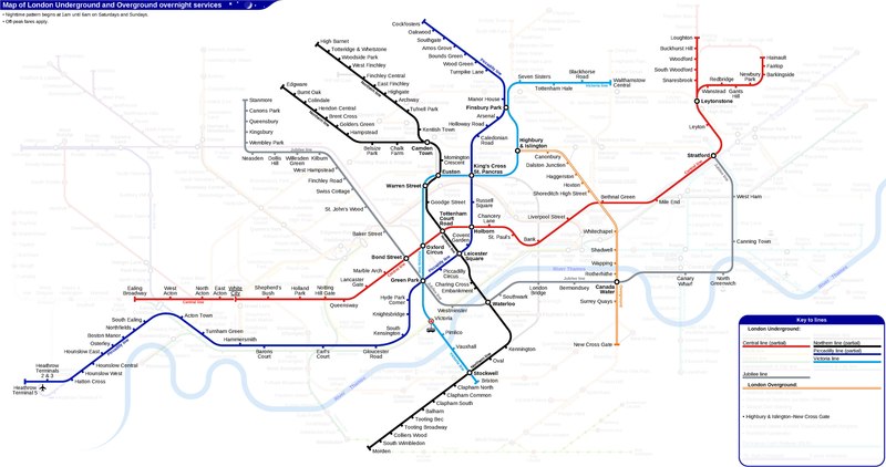
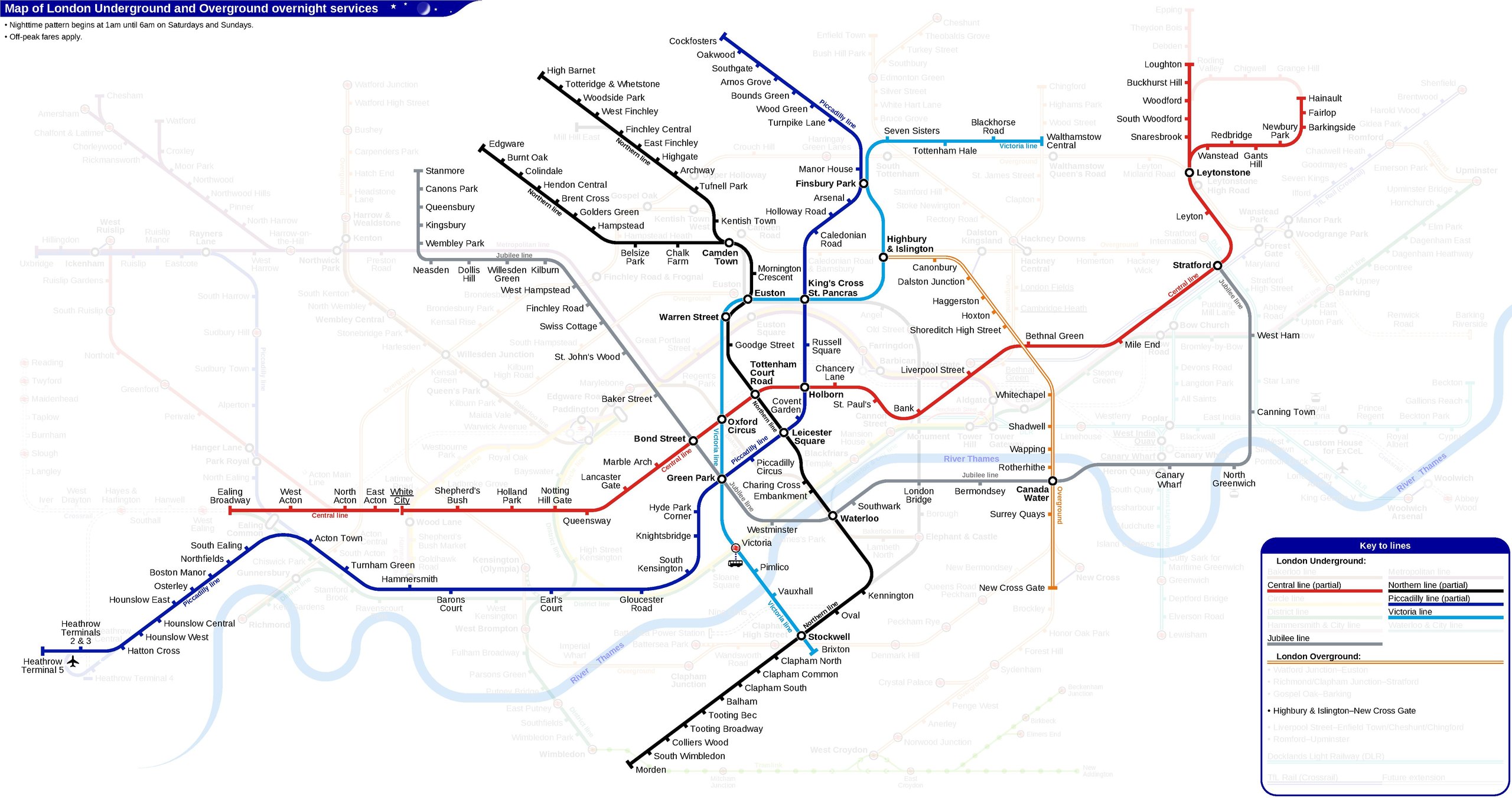
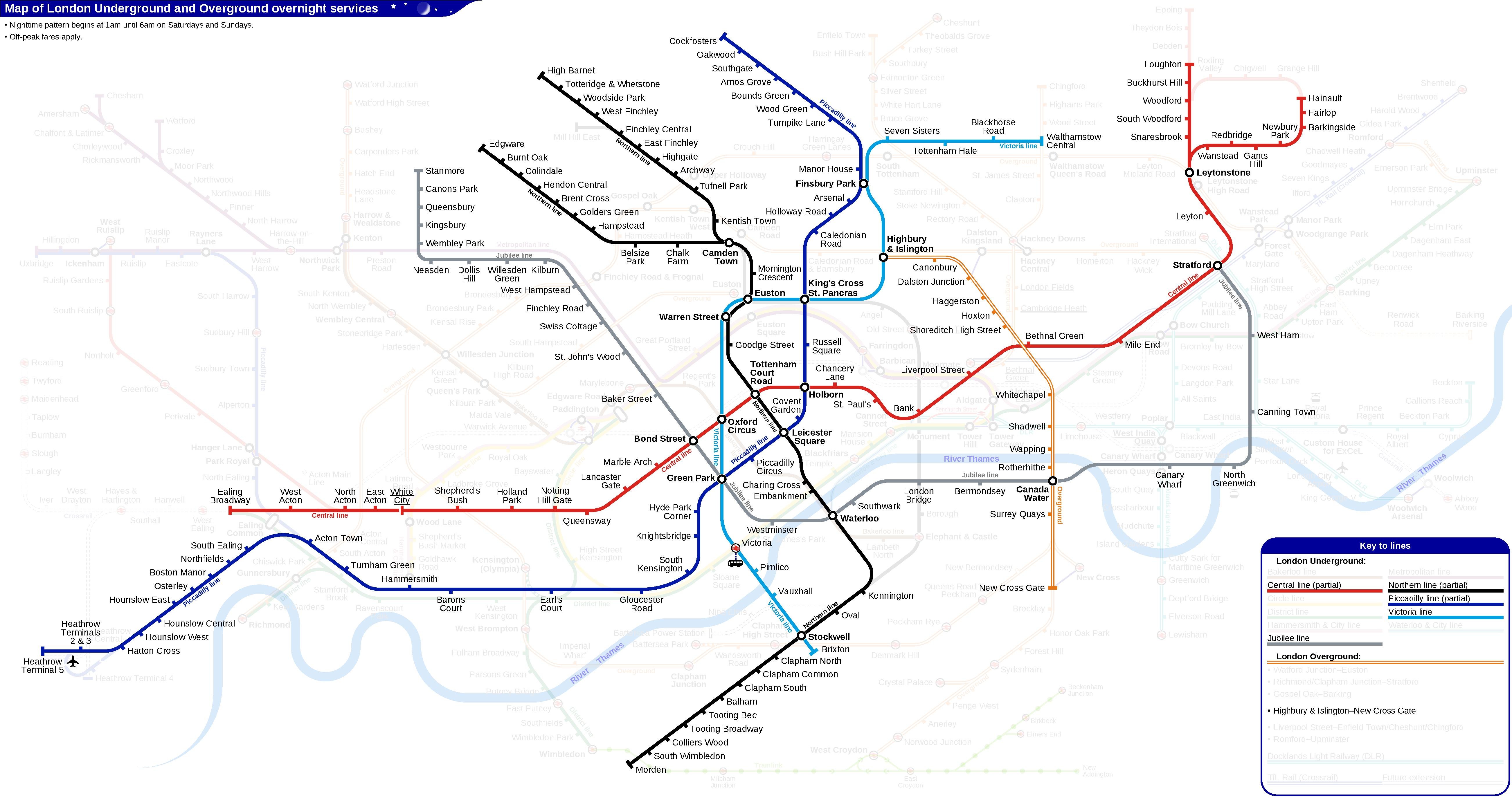
English: Route map of London Underground overnight services. |
|||
| Date | 1 July 2017, 09:45:18 (upload date) | |||
| Source | Own work | |||
| Author | Sameboat | |||
| Permission (Reusing this file) |
I, the copyright holder of this work, hereby publish it under the following license: This file is licensed under the Creative Commons Attribution-Share Alike 4.0 International license.
|
|||
| Other versions |
|


File history
Click on a date/time to view the file as it appeared at that time.
| Date/Time | Thumbnail | Dimensions | User | Comment | |
|---|---|---|---|---|---|
| current | 09:01, 23 December 2018 |  | 5,208 × 2,750 (113 KB) | Sameboat (talk | contribs) | |
| 14:31, 16 December 2018 | No thumbnail | 0 × 0 (113 KB) | Sameboat (talk | contribs) | ||
| 09:07, 16 December 2018 | No thumbnail | 0 × 0 (113 KB) | Sameboat (talk | contribs) | ||
| 10:04, 5 August 2018 | No thumbnail | 0 × 0 (113 KB) | Sameboat (talk | contribs) | ||
| 09:37, 5 August 2018 | No thumbnail | 0 × 0 (113 KB) | Sameboat (talk | contribs) | ||
| 14:43, 23 April 2018 | No thumbnail | 0 × 0 (113 KB) | Sameboat (talk | contribs) | ||
| 11:51, 15 December 2017 | No thumbnail | 0 × 0 (113 KB) | Sameboat (talk | contribs) | Overnight Overground | |
| 04:15, 1 September 2017 | No thumbnail | 0 × 0 (113 KB) | Sameboat (talk | contribs) | ||
| 23:07, 28 August 2017 | No thumbnail | 0 × 0 (113 KB) | Sameboat (talk | contribs) | ||
| 15:31, 30 July 2017 | No thumbnail | 0 × 0 (111 KB) | Sameboat (talk | contribs) |
You cannot overwrite this file.
File usage on Commons
The following 45 pages use this file:
- User:Chumwa/OgreBot/Potential transport maps/2017 August 21-31
- User:Chumwa/OgreBot/Potential transport maps/2017 December 11-20
- User:Chumwa/OgreBot/Potential transport maps/2017 July 1-10
- User:Chumwa/OgreBot/Potential transport maps/2017 July 21-31
- User:Chumwa/OgreBot/Potential transport maps/2017 September 1-10
- User:Chumwa/OgreBot/Potential transport maps/2018 April 21-30
- User:Chumwa/OgreBot/Potential transport maps/2018 August 1-10
- User:Chumwa/OgreBot/Potential transport maps/2018 December 11-20
- User:Chumwa/OgreBot/Potential transport maps/2018 December 21-31
- User:Chumwa/OgreBot/Public transport information/2017 August 21-31
- User:Chumwa/OgreBot/Public transport information/2017 December 11-20
- User:Chumwa/OgreBot/Public transport information/2017 July 1-10
- User:Chumwa/OgreBot/Public transport information/2017 July 21-31
- User:Chumwa/OgreBot/Public transport information/2017 September 1-10
- User:Chumwa/OgreBot/Public transport information/2018 April 21-30
- User:Chumwa/OgreBot/Public transport information/2018 August 1-10
- User:Chumwa/OgreBot/Public transport information/2018 December 11-20
- User:Chumwa/OgreBot/Public transport information/2018 December 21-31
- User:Chumwa/OgreBot/Transport Maps/2017 August 21-31
- User:Chumwa/OgreBot/Transport Maps/2017 December 11-20
- User:Chumwa/OgreBot/Transport Maps/2017 July 1-10
- User:Chumwa/OgreBot/Transport Maps/2017 July 21-31
- User:Chumwa/OgreBot/Transport Maps/2017 September 1-10
- User:Chumwa/OgreBot/Transport Maps/2018 April 21-30
- User:Chumwa/OgreBot/Transport Maps/2018 August 1-10
- User:Chumwa/OgreBot/Transport Maps/2018 December 11-20
- User:Chumwa/OgreBot/Transport Maps/2018 December 21-31
- User:Chumwa/OgreBot/Travel and communication maps/2017 August 21-31
- User:Chumwa/OgreBot/Travel and communication maps/2017 December 11-20
- User:Chumwa/OgreBot/Travel and communication maps/2017 July 1-10
- User:Chumwa/OgreBot/Travel and communication maps/2017 July 21-31
- User:Chumwa/OgreBot/Travel and communication maps/2017 September 1-10
- User:Chumwa/OgreBot/Travel and communication maps/2018 April 21-30
- User:Chumwa/OgreBot/Travel and communication maps/2018 August 1-10
- User:Chumwa/OgreBot/Travel and communication maps/2018 December 11-20
- User:Chumwa/OgreBot/Travel and communication maps/2018 December 21-31
- User:Mattbuck/Railways/2017 August 21-31
- User:Mattbuck/Railways/2017 December 11-20
- User:Mattbuck/Railways/2017 July 1-10
- User:Mattbuck/Railways/2017 July 21-31
- User:Mattbuck/Railways/2017 September 1-10
- User:Mattbuck/Railways/2018 April 21-30
- User:Mattbuck/Railways/2018 August
- User:Mattbuck/Railways/2018 December
- File:London Underground Overground DLR Crossrail map night.svg
File usage on other wikis
The following other wikis use this file:
- Usage on en.wikipedia.org