File:Letter, April 1921 page 2 (d545b713-786c-495b-b725-d08a0d6a529f).tif

Original file (2,409 × 3,207 pixels, file size: 29.47 MB, MIME type: image/tiff)
Captions
Captions

|
The categories of this image need checking. You can do so here.
|
Summary[edit]
| English: Letter, April 1921 page 2 | |||
|---|---|---|---|
| Photographer |
Unknown author |
||
| Title |
English: Letter, April 1921 page 2 |
||
| Description |
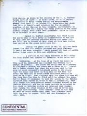
English: Scanned image of form. See description for text. this region, as shown by the records of the U.S. Weather Bureau kept at Roswell, 15 miles north, is 14.13 inches, 9.77 inches of which occurs during crop-growing season from April 11 to October 21. Experience has shown that this is insufficient moisture for the successful practice of dry farming in this locality, particularly in view of the fact that during the early portion of the crop growing season, when grain seed germinate, there is little or no rainfall in most years. Samuel H. Bostick constructed the fence along the north line of this entry in consideration of the use of this land for grazing purposes during the years 1915 and 1916, and he grazed as many stock on this land during that period as the grass would care for. During the years 1917-18 and 19, William Swets leased the land for grazing purposes and paid claimant 10 cents per acre therefor. Swets grazed 150 head of cattle during those years on this and adjoining lands. A portion of the lands embraced in this entry has been disked and planted to feterita, which dried out. RESIDENCE: At the time of my visit the house on this land was abandoned and the claimant was working in a garage at Roswell. The house was being used as a granary by claimant’s father, but there was a stove in it. Claimant’s father stated that when the entryman went to the Army he moved claimant’s household goods to his place; that the house was built on this land at the time the entry was made and he established residence therein as soon as he filed; that claimant made the place his home all the time from the time he filed until he entered the Army, but he found it necessary to work for people in the farming district near Dexter in order to make a livelihood; that only during the crop growing season claimant worked in the farming district, and during these periods he returned to his place on Saturday nights and remained over Sunday; that during the other seasons of the year he lived upon the land continuously; that claimant lived on the land as much as seven months each year; that claimant went into the Army in August, 1918, and was discharged in July, 1919. -2- [stamp] CONFIDENTIAL NOT FOR PUBLIC INSPECTION
|
||
| Depicted place |
English: Chaves County, New Mexico; Homestead National Historical Park, Gage County, Nebraska; Latitude: 40.2879981994629, Longitude: -96.8339004516602 |
||
| Date | between 1915 and 1921 | ||
| Accession number | |||
| Source |
English: NPGallery |
||
| Permission (Reusing this file) |
|
||
| Contacts | English: Organization: Homestead National Historical Park Address: 8523 W State Highway 4, Beatrice, NE 68310 |
||
| NPS Unit Code | HOME | ||
File history
Click on a date/time to view the file as it appeared at that time.
| Date/Time | Thumbnail | Dimensions | User | Comment | |
|---|---|---|---|---|---|
| current | 12:54, 16 January 2022 |  | 2,409 × 3,207 (29.47 MB) | BMacZeroBot (talk | contribs) | Batch upload (Commons:Batch uploading/NPGallery) |
You cannot overwrite this file.
File usage on Commons
The following page uses this file: