File:Kosovo municipalities.svg
Jump to navigation
Jump to search

Size of this PNG preview of this SVG file: 269 × 296 pixels. Other resolutions: 218 × 240 pixels | 436 × 480 pixels | 698 × 768 pixels | 931 × 1,024 pixels | 1,861 × 2,048 pixels.
Original file (SVG file, nominally 269 × 296 pixels, file size: 426 KB)
Captions
Captions
Add a one-line explanation of what this file represents
Summary[edit]
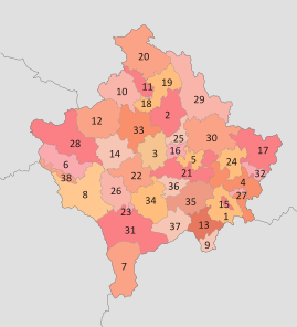
| Description | Numbered map of the municipalities of Kosovo, also showing the district divisions |
| Source | sr:File:Kosovo.pdf; LAW ON ADMINISTRATIVE MUNICIPAL BOUNDARIES; Municipalities web sites of Republic of Kosovo |
| Author | Пакко and Варја |
Licensing[edit]
I, the copyright holder of this work, hereby publish it under the following licenses:

|
Permission is granted to copy, distribute and/or modify this document under the terms of the GNU Free Documentation License, Version 1.2 or any later version published by the Free Software Foundation; with no Invariant Sections, no Front-Cover Texts, and no Back-Cover Texts. A copy of the license is included in the section entitled GNU Free Documentation License. |
This file is licensed under the Creative Commons Attribution-Share Alike Attribution-Share Alike 4.0 International, 3.0 Unported, 2.5 Generic, 2.0 Generic and 1.0 Generic license.
- You are free:
- to share – to copy, distribute and transmit the work
- to remix – to adapt the work
- Under the following conditions:
- attribution – You must give appropriate credit, provide a link to the license, and indicate if changes were made. You may do so in any reasonable manner, but not in any way that suggests the licensor endorses you or your use.
- share alike – If you remix, transform, or build upon the material, you must distribute your contributions under the same or compatible license as the original.
You may select the license of your choice.
File history
Click on a date/time to view the file as it appeared at that time.
| Date/Time | Thumbnail | Dimensions | User | Comment | |
|---|---|---|---|---|---|
| current | 16:46, 28 June 2017 | | 269 × 296 (426 KB) | Hakuli (talk | contribs) | Border fixed |
| 13:17, 23 June 2011 |  | 337 × 371 (453 KB) | Пакко (talk | contribs) | upg according new administrative borders | |
| 14:35, 28 February 2008 |  | 267 × 292 (299 KB) | Future Perfect at Sunrise (talk | contribs) | fix numbering | |
| 20:43, 27 February 2008 |  | 267 × 292 (300 KB) | Jackaranga (talk | contribs) | removed labels for districts | |
| 20:33, 27 February 2008 |  | 630 × 490 (302 KB) | Jackaranga (talk | contribs) | colours + typo | |
| 15:22, 26 February 2008 |  | 630 × 490 (302 KB) | Jackaranga (talk | contribs) | hiding the labels in a manner mediawiki understands I hope | |
| 15:20, 26 February 2008 |  | 630 × 490 (302 KB) | Jackaranga (talk | contribs) | {{Information |Description= Numbered map of the municipalities of Kosovo, also showing the district devisions (+ hidden layer with district names that can be switched on in Inkscape if needed) |Source= Image:Kosovo admin.svg [[:Image:Kosovo municipal |
You cannot overwrite this file.
File usage on Commons
The following page uses this file:
File usage on other wikis
The following other wikis use this file:
- Usage on en.wikipedia.org