File:Kojenstein Hochhädrich Panorama.jpg
Jump to navigation
Jump to search

Size of this preview: 800 × 230 pixels. Other resolutions: 320 × 92 pixels | 640 × 184 pixels | 1,024 × 295 pixels | 1,280 × 368 pixels | 2,560 × 736 pixels | 7,481 × 2,152 pixels.
Original file (7,481 × 2,152 pixels, file size: 9.91 MB, MIME type: image/jpeg)
Captions
Captions
Add a one-line explanation of what this file represents
| Description |
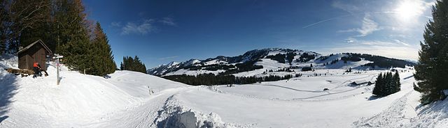
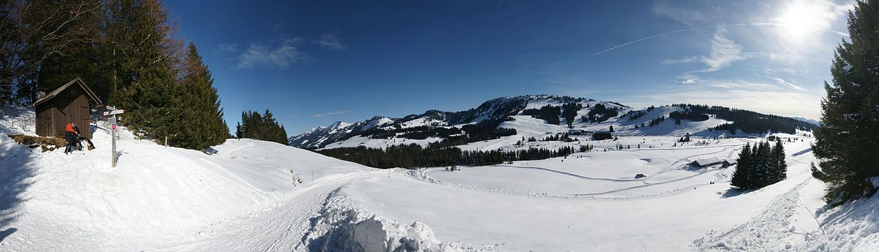
Deutsch: Das 180° Panorama, am Standort Kojenstein in Riefensberg, zeigt im Tal die Alpe Kojen, in der Bildmitte das Skigebiet um den Hochhädrich in Hittisau und links die Nagelfluhkette der Allgäuer Alpen. |
| Date | |
| Source | Own work |
| Author | böhringer friedrich |
| Permission (Reusing this file) |
I, the copyright holder of this work, hereby publish it under the following license: This file is licensed under the Creative Commons Attribution-Share Alike 2.5 Generic license.
|
This Photo was taken by Böhringer Friedrich.
|
Feel free to use my photos, but please mention me as the author and if you want send me a message. or (rufre@lenz-nenning.at) |
| Camera location | | View this and other nearby images on: OpenStreetMap |
|---|
| Annotations | This image is annotated: View the annotations at Commons |
This image has been assessed using the Quality image guidelines and is considered a Quality image.
|
File history
Click on a date/time to view the file as it appeared at that time.
| Date/Time | Thumbnail | Dimensions | User | Comment | |
|---|---|---|---|---|---|
| current | 20:24, 2 March 2010 | 7,481 × 2,152 (9.91 MB) | Böhringer (talk | contribs) | {{Information |Description= {{de| Das 180° Panorama, am Standort Kojenstein in Riefensberg, zeigt im Tal die Alpe Kojen, in der Bildmitte das Skigebiet um den Hochhädrich in Hittisau und links die [[:de:Nagelfluhkett |
You cannot overwrite this file.
File usage on Commons
The following 3 pages use this file:
File usage on other wikis
The following other wikis use this file:
- Usage on fr.wikipedia.org