File:Kingdom of Man and the Isles map (island groups).png
Jump to navigation
Jump to search

Size of this preview: 354 × 600 pixels. Other resolutions: 141 × 240 pixels | 283 × 480 pixels | 453 × 768 pixels | 1,065 × 1,805 pixels.
Original file (1,065 × 1,805 pixels, file size: 1.82 MB, MIME type: image/png)
Captions
Captions
Add a one-line explanation of what this file represents
Summary[edit]
.png&action=edit§ion=1)
| Description |
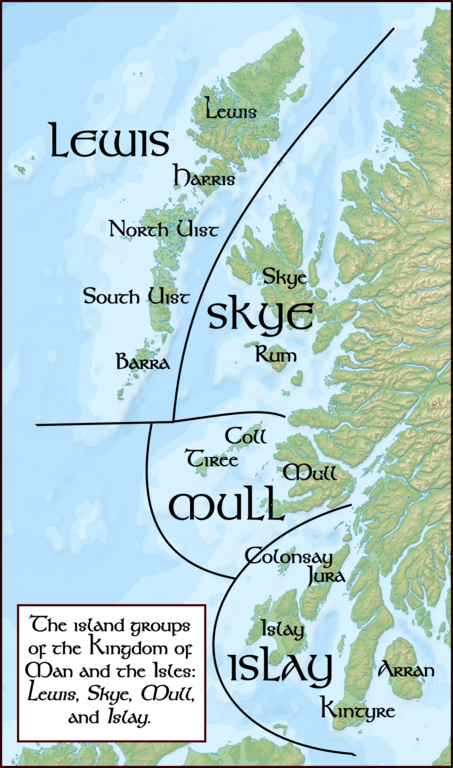
English: Map showing some of the locations mentioned in the article concerning Gofraid Donn. This map is based off a map (titled "The Kingdom of Man and the Isles", on page 60) shown in The Isle of man: a social, cultural and political history, by R.H. Kinvig, 1975. Kinvig' map states that it is uncertain if Kintyre, and Arran were originally part of the Islay group. |
| Date | |
| Source |
English: I, Brianann MacAmhlaidh, created this work entirely by myself. The font I used is Kelt Bold Unicode 2.0. I created this image using Inkscape, which is a vector graphics program distributed under a free software license.
I utilized the following file in creating this image: File:Scotland map of whisky distilleries-fr.svg by User:Ayack, who released it under a GNU Free Documentation License and several Creative Commons Attribution-Share Alike licences. |
| Author | Brianann MacAmhlaidh (talk) |
| Permission (Reusing this file) |
I, the copyright holder of this work, hereby publish it under the following license: This file is licensed under the Creative Commons Attribution-Share Alike 3.0 Unported license.
|
File history
Click on a date/time to view the file as it appeared at that time.
| Date/Time | Thumbnail | Dimensions | User | Comment | |
|---|---|---|---|---|---|
| current | 09:16, 19 July 2010 | | 1,065 × 1,805 (1.82 MB) | Brianann MacAmhlaidh (talk | contribs) | ==Summary== {{Information |Description = {{en|Map showing some of the locations mentioned in the article concerning Godred the Brown. This map is based off a map shown in ''The Isle of man: a social, cultural and political hist |
You cannot overwrite this file.
File usage on Commons
There are no pages that use this file.
File usage on other wikis
The following other wikis use this file:
- Usage on ru.wikipedia.org
.png&oldid=462649590)