File:Karte Slowakischer Nationalaufstand 1944 - Aufstandsbeginn.png

Original file (2,013 × 1,107 pixels, file size: 1.96 MB, MIME type: image/png)
Captions
Captions
Summary[edit]
| Description |
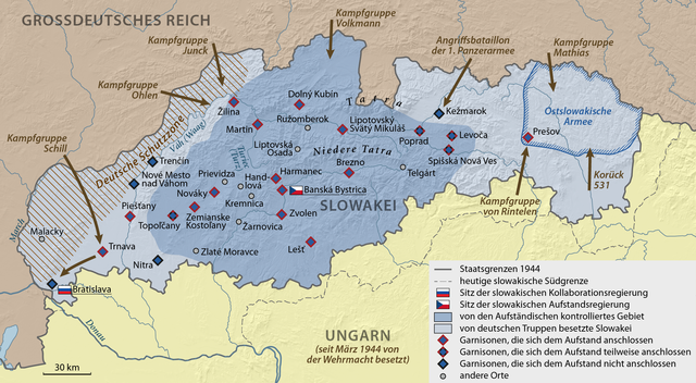
Deutsch: Karte zum Aufstandsbeginn des Slowakischen Nationalaufstands 1944 |
| Date | |
| Source |
Own work using:
|
| Author | NordNordWest |
| Other versions |
|


|
This map has been made or improved in the German Kartenwerkstatt (Map Lab). You can propose maps to improve as well.
|
Licensing[edit]
Usage of this file with:

explanatory notes: Legally binding is only the full legalcode. For a free usage I recommend to respect the following licence conditions:
1. Provide my name as given above: NordNordWest,
2. a copy of, or the URI for, the applicable license: https://creativecommons.org/licenses/by-sa/3.0/de/legalcode,
3. the title of the work,
4. in the case of an adaptation, a credit identifying the use of the work in the adaptation.
This license and the rights granted hereunder will terminate automatically upon any breach by you of the terms of this license. Any of the above conditions can be waived if you get permission from the copyright holder. If you have questions or wish differing conditions, please contact me through nnwest or my discussion page ![]() t-online.de
t-online.de
- You are free:
- to share – to copy, distribute and transmit the work
- to remix – to adapt the work
- Under the following conditions:
- attribution – You must give appropriate credit, provide a link to the license, and indicate if changes were made. You may do so in any reasonable manner, but not in any way that suggests the licensor endorses you or your use.
- share alike – If you remix, transform, or build upon the material, you must distribute your contributions under the same or compatible license as the original.


|
This image has been assessed under the valued image criteria and is considered the most valued image on Commons within the scope: Maps of the Slovak National Uprising, showing the beginning of the uprising. You can see its nomination here. |
File history
Click on a date/time to view the file as it appeared at that time.
| Date/Time | Thumbnail | Dimensions | User | Comment | |
|---|---|---|---|---|---|
| current | 18:40, 29 February 2020 | | 2,013 × 1,107 (1.96 MB) | NordNordWest (talk | contribs) | c |
| 18:32, 29 February 2020 |  | 2,013 × 1,107 (1.99 MB) | NordNordWest (talk | contribs) | c | |
| 18:28, 29 February 2020 |  | 2,013 × 1,107 (1.96 MB) | NordNordWest (talk | contribs) | c | |
| 10:10, 31 May 2015 |  | 2,013 × 1,107 (2.01 MB) | NordNordWest (talk | contribs) | corr | |
| 19:06, 27 May 2015 |  | 2,013 × 1,107 (2 MB) | NordNordWest (talk | contribs) | == {{int:filedesc}} == {{Information |Description= {{de|1=Karte zum Aufstandsbeginn des Slowakischen Nationalaufstands 1944}} |Source={{Own using}} * United States National Imagery and Mapping Agency data * SRTM30 v.2 data |Date={{Date|2015|05|27}} |Au... |
You cannot overwrite this file.
File usage on Commons
The following 11 pages use this file:
- User:Magog the Ogre/Maps of conflicts/2015 May
- User:Magog the Ogre/Maps of conflicts/2020 February
- User:NordNordWest/Gallery/Maps
- User talk:Buidhe
- Commons:Valued image candidates/Karte Slowakischer Nationalaufstand 1944 - Aufstandsbeginn.png
- Commons:WikiProject Aviation/recent uploads/2015 May 27
- Commons:WikiProject Aviation/recent uploads/2015 May 31
- Commons:WikiProject Aviation/recent uploads/2020 February 29
- File:Karte Slowakischer Nationalaufstand 1944 - Aufstandsbeginn.png
- File:Karte Slowakischer Nationalaufstand 1944 - Schlussoffensive.png
- File:Map Slovak National Uprising in 1944 - first days.png
File usage on other wikis
The following other wikis use this file:
- Usage on de.wikipedia.org
- Usage on sr.wikipedia.org