File:Kaisaniemen puisto 1918.tif
Jump to navigation
Jump to search

Size of this JPG preview of this TIF file: 573 × 600 pixels. Other resolutions: 229 × 240 pixels | 459 × 480 pixels | 734 × 768 pixels | 978 × 1,024 pixels | 1,957 × 2,048 pixels | 7,937 × 8,307 pixels.
Original file (7,937 × 8,307 pixels, file size: 161.51 MB, MIME type: image/tiff)
Captions
Captions
Add a one-line explanation of what this file represents
Summary[edit]
| Description |
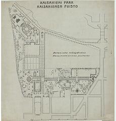
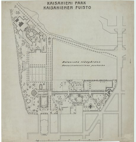
Suomi: Kaisaniemen puistosuunnitelma 1918 |
|||||||||
| Date | ||||||||||
| Source | https://yksa3.darchive.fi/YKSA3/public/files/141269093867400/YAM100211 | |||||||||
| Creator |
Helsingin kaupungin Kiinteistövirasto, Kaupunkimittausosasto |
|||||||||
| Geotemporal data | ||||||||||
| Bounding box |
|
|||||||||
| Georeferencing | ||||||||||
Licensing[edit]
|
This work is in the public domain in its country of origin and other countries and areas where the copyright term is the author's life plus 70 years or fewer. This work is in the public domain in the United States because it was published (or registered with the U.S. Copyright Office) before January 1, 1929. | |
| This file has been identified as being free of known restrictions under copyright law, including all related and neighboring rights. | |
File history
Click on a date/time to view the file as it appeared at that time.
| Date/Time | Thumbnail | Dimensions | User | Comment | |
|---|---|---|---|---|---|
| current | 16:37, 13 December 2016 |  | 7,937 × 8,307 (161.51 MB) | Susannaanas (talk | contribs) | User created page with UploadWizard |
You cannot overwrite this file.
File usage on Commons
There are no pages that use this file.