File:Israel Bezirke.png
Jump to navigation
Jump to search

Size of this preview: 216 × 598 pixels. Other resolutions: 86 × 240 pixels | 350 × 969 pixels.
Original file (350 × 969 pixels, file size: 41 KB, MIME type: image/png)
Captions
Captions
Add a one-line explanation of what this file represents
Summary[edit]
| Description |
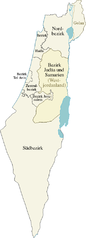
Deutsch: Karte der Bezirke von Israel, deutsche Version
English: Map of the districts of Israel, German version |
| Date | |
| Source | own work, translating Israel districts.png by Ynhockey |
| Author | NordNordWest |
| Other versions |
|
Licensing[edit]
| I, the copyright holder of this work, release this work into the public domain. This applies worldwide. In some countries this may not be legally possible; if so: I grant anyone the right to use this work for any purpose, without any conditions, unless such conditions are required by law. |
File history
Click on a date/time to view the file as it appeared at that time.
| Date/Time | Thumbnail | Dimensions | User | Comment | |
|---|---|---|---|---|---|
| current | 16:37, 16 November 2008 | 350 × 969 (41 KB) | NordNordWest (talk | contribs) | {{Information |Description= {{de|Karte der Bezirke von Israel, deutsche Version}} {{en|Map of the districts of Israel, German version}} |Source=own work, translating Israel districts.png by [[: |
You cannot overwrite this file.
File usage on Commons
The following 11 pages use this file:
- File:Disdrigoù Israel.png
- File:Distritos Israel.PNG
- File:Dystrykty Izraela.svg
- File:Dystrykty Izraela (PNG).png
- File:Israel Bezirke.png
- File:Israel districts.png
- File:Israel districts he.png
- File:Israel districts in farsi.png
- File:Israel districts numbered.png
- File:Israel districts numbered.svg
- File:Округа Израиля.PNG
.png)