File:Irish Sea – relief, ports, limits.tif
Jump to navigation
Jump to search

Size of this JPG preview of this TIF file: 415 × 600 pixels. Other resolutions: 166 × 240 pixels | 332 × 480 pixels | 531 × 768 pixels | 1,043 × 1,507 pixels.
Original file (1,043 × 1,507 pixels, file size: 4.5 MB, MIME type: image/tiff)
Captions
Captions
Add a one-line explanation of what this file represents
Summary[edit]
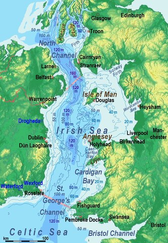
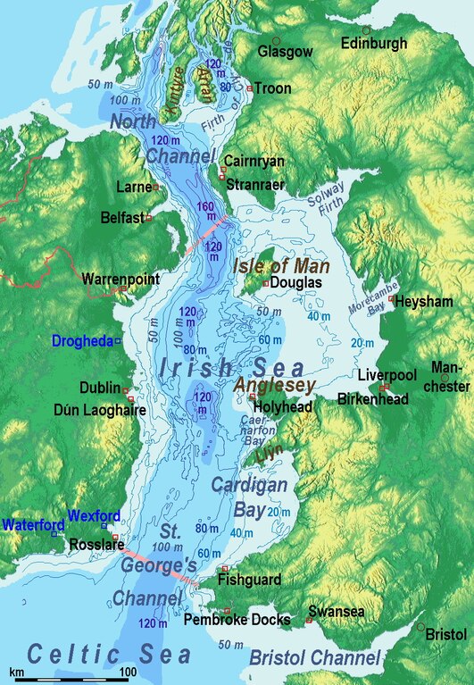
| Description | Bathysmographic map of the en:Irish Sea. Major ports shown with red marks. freight-only ports in blue. |
| Date | |
| Source | Own work, the countures of depth are drawn by myself according to the UK source, the areal colours are derived from the Irish one. The land is from Maps for Free. |
| Author | Ulamm (talk) |
| Other versions |
Sources of information[edit]
- internal report Nr. 174 of the National Oceanography Centre (Liverpool)
- http://www.dcenr.gov.ie (Department of Communications, Energy and Natural Resources) -> IOSEA4Annex–Master–r02–Fiinal.pdf (Fourth Strategic Environmental Assessment for Oil and Gas ACtivity in Irelands Offshore Waters) -> figures 2.1 & 2.2a
Licensing[edit]
I, the copyright holder of this work, hereby publish it under the following license:
This file is licensed under the Creative Commons Attribution-Share Alike 3.0 Unported license.
- You are free:
- to share – to copy, distribute and transmit the work
- to remix – to adapt the work
- Under the following conditions:
- attribution – You must give appropriate credit, provide a link to the license, and indicate if changes were made. You may do so in any reasonable manner, but not in any way that suggests the licensor endorses you or your use.
- share alike – If you remix, transform, or build upon the material, you must distribute your contributions under the same or compatible license as the original.
File history
Click on a date/time to view the file as it appeared at that time.
| Date/Time | Thumbnail | Dimensions | User | Comment | |
|---|---|---|---|---|---|
| current | 15:17, 14 December 2014 |  | 1,043 × 1,507 (4.5 MB) | Ulamm (talk | contribs) | {{Information |Description = Bathysmographic map of the en:Irish Sea. Major ports shown with red marks. freight-only ports in blue. |Source = {{own}}, the countures of depth are drawn by myself according to the UK source, the areal colours are der... |
You cannot overwrite this file.
File usage on Commons
There are no pages that use this file.
File usage on other wikis
The following other wikis use this file:
- Usage on azb.wikipedia.org
- Usage on bh.wikipedia.org
- Usage on ckb.wikipedia.org
- Usage on de.wikipedia.org
- Usage on en.wikipedia.org
- Usage on eu.wikipedia.org
- Usage on frr.wikipedia.org
- Usage on fr.wikipedia.org
- Usage on fy.wikipedia.org
- Usage on gl.wikipedia.org
- Usage on hsb.wikipedia.org
- Usage on li.wiktionary.org
- Usage on lv.wikipedia.org
- Usage on nl.wikipedia.org
- Usage on pt.wikipedia.org
- Usage on sr.wikipedia.org
- Usage on sw.wikipedia.org
- Usage on th.wikipedia.org
- Usage on uz.wikipedia.org
- Usage on vi.wikipedia.org
- Usage on vls.wikipedia.org