File:India Assam COVID-19 Death map.svg
Jump to navigation
Jump to search

Size of this PNG preview of this SVG file: 725 × 600 pixels. Other resolutions: 290 × 240 pixels | 580 × 480 pixels | 928 × 768 pixels | 1,238 × 1,024 pixels | 2,475 × 2,048 pixels | 765 × 633 pixels.
Original file (SVG file, nominally 765 × 633 pixels, file size: 769 KB)
Captions
Captions
Add a one-line explanation of what this file represents
Summary[edit]
| Description |
Deutsch: Distrikteinteilung von Assam im Jahr 2014. English: This file shows the districts of Assam as of 2014.
English: Districts of Assam as of 2014. In August 2015, five new districts were formed. Those were not shown in this map.
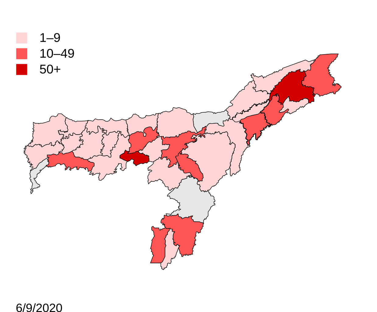
English: Districts with confirmed cases in the state of Assam, as of 7 April 2020. Confirmed cases reported [1]. Note: * This map does not show the newer districts that were created after 2014. * The new districts are Chirag, Baksa, Odalguri and Kamrup Metropolitan |
| Date | (UTC) |
| Source |
This file was derived from: |
| Author |
Derived work: Simbu123
|
.svg)
| This is a retouched picture, which means that it has been digitally altered from its original version. Modifications: marking COVID 19 death district map. The original can be viewed here: India Assam COVID-19 map.svg:
|
Licensing[edit]
This file is licensed under the Creative Commons Attribution-Share Alike 3.0 Unported license.
- You are free:
- to share – to copy, distribute and transmit the work
- to remix – to adapt the work
- Under the following conditions:
- attribution – You must give appropriate credit, provide a link to the license, and indicate if changes were made. You may do so in any reasonable manner, but not in any way that suggests the licensor endorses you or your use.
- share alike – If you remix, transform, or build upon the material, you must distribute your contributions under the same or compatible license as the original.
Original upload log[edit]
This image is a derivative work of the following images:
- File:Distrikte von Assam.svg licensed with Cc-by-sa-3.0, GFDL
- 2015-03-05T02:30:50Z Furfur 765x633 (83178 Bytes) zentriert
- 2015-03-05T02:28:55Z Furfur 765x633 (83283 Bytes) North Kachar Hills -> Dima Hasao
- 2014-12-28T22:00:15Z Furfur 765x633 (83788 Bytes) == {{int:filedesc}} == {{Information |Description={{de|1=Distrikteinteilung von [[:de:Assam|Assam]] im Jahr 2014.}}{{en|1=This file shows the districts of [[:en:Assam|Assam]] as of 2014.}} |Source=*[http://online.assam.gov.in
- File:Districts of Assam (2014).svg licensed with Cc-by-sa-3.0
- 2015-08-15T18:58:47Z Simbu123 765x633 (87108 Bytes) {{Information |Description ={{en|1=Districts of Assam as of 2014. In August 2015, five new districts were formed. Those were not shown in this map.}} |Source ={{Derived from|Distrikte von Assam.svg|display=50}} |Au
- File:India Assam COVID-19 map.svg licensed with Cc-by-sa-3.0, GFDL
- 2020-04-08T01:00:18Z Firos ak 765x633 (102253 Bytes) Haila kandi
- 2020-04-05T16:40:05Z Firos ak 765x633 (102255 Bytes) Dhubri+
- 2020-04-05T07:14:04Z Firos ak 765x633 (102276 Bytes) 2014 map
- 2020-04-04T18:34:25Z Firos ak 631x530 (355983 Bytes) == {{int:filedesc}} == {{Information |Description={{en|1=This file shows the districts of [[:en:Assam]] as of 2001. The map is based on a free hand trace of [https://web.archive.org/web/20040606141014/www.censusindia.net/res
Uploaded with derivativeFX
File history
Click on a date/time to view the file as it appeared at that time.
| Date/Time | Thumbnail | Dimensions | User | Comment | |
|---|---|---|---|---|---|
| current | 04:41, 7 September 2020 | | 765 × 633 (769 KB) | Shanze1 (talk | contribs) | update |
| 05:03, 24 August 2020 |  | 765 × 633 (769 KB) | Shanze1 (talk | contribs) | update | |
| 04:01, 14 August 2020 |  | 765 × 633 (769 KB) | Shanze1 (talk | contribs) | update | |
| 02:39, 5 August 2020 |  | 765 × 633 (768 KB) | Shanze1 (talk | contribs) | update | |
| 04:28, 29 July 2020 |  | 765 × 633 (768 KB) | Shanze1 (talk | contribs) | update | |
| 03:16, 21 July 2020 |  | 765 × 633 (766 KB) | Shanze1 (talk | contribs) | update | |
| 04:13, 14 July 2020 |  | 765 × 633 (766 KB) | Shanze1 (talk | contribs) | update | |
| 03:54, 9 July 2020 |  | 765 × 633 (766 KB) | Shanze1 (talk | contribs) | update | |
| 03:40, 4 July 2020 |  | 765 × 633 (766 KB) | Shanze1 (talk | contribs) | Reverted to version as of 03:23, 2 July 2020 (UTC) | |
| 03:38, 4 July 2020 |  | 765 × 633 (766 KB) | Shanze1 (talk | contribs) | update |
You cannot overwrite this file.
File usage on Commons
The following 14 pages use this file:
- User:Magog the Ogre/Multilingual legend/2020 April 11-20
- User:Magog the Ogre/Multilingual legend/2020 August 1-10
- User:Magog the Ogre/Multilingual legend/2020 August 11-20
- User:Magog the Ogre/Multilingual legend/2020 August 21-31
- User:Magog the Ogre/Multilingual legend/2020 July 1-10
- User:Magog the Ogre/Multilingual legend/2020 July 11-20
- User:Magog the Ogre/Multilingual legend/2020 July 21-31
- User:Magog the Ogre/Multilingual legend/2020 June 1-10
- User:Magog the Ogre/Multilingual legend/2020 June 11-20
- User:Magog the Ogre/Multilingual legend/2020 June 21-30
- User:Magog the Ogre/Multilingual legend/2020 May 11-20
- User:Magog the Ogre/Multilingual legend/2020 May 21-31
- User:Magog the Ogre/Multilingual legend/2020 September 1-10
- User talk:Shanze1
File usage on other wikis
The following other wikis use this file:
- Usage on id.wikipedia.org
- Usage on kn.wikipedia.org