File:Iberia 300BC-es.svg
Jump to navigation
Jump to search

Size of this PNG preview of this SVG file: 727 × 599 pixels. Other resolutions: 291 × 240 pixels | 582 × 480 pixels | 932 × 768 pixels | 1,242 × 1,024 pixels | 2,484 × 2,048 pixels | 986 × 813 pixels.
Original file (SVG file, nominally 986 × 813 pixels, file size: 1.8 MB)
Captions
Captions
Add a one-line explanation of what this file represents
Summary[edit]
| Description |
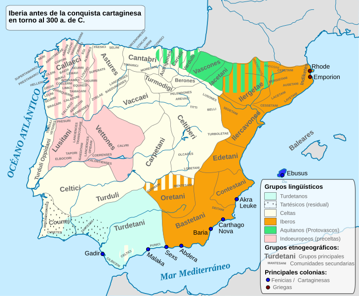
English: Ethnographic and Linguistic Map of the Iberian Peninsula at about 300 BCE (before the Carthaginian conquests). Español: La península ibérica en torno al año 300 a. de C. |
| Date | |
| Source |
This file was derived from: Iberia 300BC-en.svg : Alcides Pinto, |
| Author |
|
Licensing[edit]
I, the copyright holder of this work, hereby publish it under the following license:
This file is licensed under the Creative Commons Attribution-Share Alike 4.0 International license.
- You are free:
- to share – to copy, distribute and transmit the work
- to remix – to adapt the work
- Under the following conditions:
- attribution – You must give appropriate credit, provide a link to the license, and indicate if changes were made. You may do so in any reasonable manner, but not in any way that suggests the licensor endorses you or your use.
- share alike – If you remix, transform, or build upon the material, you must distribute your contributions under the same or compatible license as the original.
File history
Click on a date/time to view the file as it appeared at that time.
| Date/Time | Thumbnail | Dimensions | User | Comment | |
|---|---|---|---|---|---|
| current | 17:58, 25 January 2017 | | 986 × 813 (1.8 MB) | Rowanwindwhistler (talk | contribs) | Fake text added |
| 17:47, 8 September 2014 |  | 924 × 762 (762 KB) | Rowanwindwhistler (talk | contribs) | User created page with UploadWizard |
You cannot overwrite this file.
File usage on Commons
The following page uses this file:
File usage on other wikis
The following other wikis use this file:
- Usage on an.wikipedia.org
- Usage on ast.wikipedia.org
- Usage on bg.wikipedia.org
- Usage on br.wikipedia.org
- Usage on ca.wikipedia.org
- Usage on en.wikipedia.org
- Usage on eo.wikipedia.org
- Usage on es.wikipedia.org
- Idiomas de España
- Iberia
- Lenguas paleohispánicas
- Vacceos
- Idioma tartésico
- Astures
- Cántabros
- Prehistoria en la península ibérica
- Vetones
- Alce (Celtiberia)
- Pelendones
- Turdetanos
- Turmogos
- Berones
- Arévacos
- Lusones
- Celtiberia
- Galaicos
- Oretanos
- Bellos
- Olcades
- Discusión:García
- Titos
- Historia antigua de la península ibérica
- Dama de Castellar
- Lobo de El Pajarillo
- Dama Oferente de Castellar
- Protohistoria de la península ibérica
- Túrdulos viejos
- Turboletas
- Racialismo en Cataluña
- Usuario:Hodolog/MvAM/Planta Primera/Salas/Sala XII
- Sustrato lingüístico del español
- Usage on es.wikibooks.org
- Usage on et.wikipedia.org
- Usage on eu.wikipedia.org
View more global usage of this file.