File:ITER participants.png
Jump to navigation
Jump to search

Size of this preview: 800 × 351 pixels. Other resolutions: 320 × 140 pixels | 640 × 281 pixels | 1,425 × 625 pixels.
Original file (1,425 × 625 pixels, file size: 37 KB, MIME type: image/png)
Captions
Captions
Add a one-line explanation of what this file represents

|
File:ITER participants.svg is a vector version of this file. It should be used in place of this PNG file when not inferior.
File:ITER participants.png → File:ITER participants.svg
For more information, see Help:SVG. |
 |
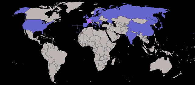
| Description | Map of ITER participants - not showing overseas territories of the EU. (France and Cadarache -the host location - highlighted) |
| Date | (UTC) |
| Source | |
| Author |
|
| Other versions |
|
| This is a retouched picture, which means that it has been digitally altered from its original version. The original can be viewed here: BlankMap-World-v7.png:
|
I, the copyright holder of this work, hereby publish it under the following licenses:
| This file is licensed under the Creative Commons Attribution-Share Alike 3.0 Unported license. | ||
| ||
| This licensing tag was added to this file as part of the GFDL licensing update. |

|
Permission is granted to copy, distribute and/or modify this document under the terms of the GNU Free Documentation License, Version 1.2 or any later version published by the Free Software Foundation; with no Invariant Sections, no Front-Cover Texts, and no Back-Cover Texts. A copy of the license is included in the section entitled GNU Free Documentation License. |
You may select the license of your choice.
Original upload log[edit]
This image is a derivative work of the following images:
- File:BlankMap-World-v7.png licensed with Cc-by-sa-3.0-migrated, GFDL
- 2010-01-16T07:36:16Z Happenstance 1425x625 (27705 Bytes) fx
- 2010-01-16T07:34:59Z Happenstance 1425x625 (27625 Bytes) darker colour for easier editing in Photoshop (so it doesn't default to grey-scale)
- 2008-07-31T14:49:14Z Avala 1425x625 (49260 Bytes)
- 2008-07-07T08:09:15Z Eynar 1425x625 (49297 Bytes) Updated according to [[:Image:BlankMap-World-v7-Borders.png]]: Fixed connecting pixel between Argentina and Chile. Added Canary Islands, Madeira and Azores (Canary Islands have a total area of 7447 km2, so I put their shape i
- 2008-03-22T21:59:58Z Nightstallion 1425x625 (49095 Bytes) Reverted to version as of 16:40, 13 March 2008
- 2008-03-19T19:33:32Z Patstuart 1425x625 (49058 Bytes) Reverted to version as of 18:25, 11 March 2008 - see [[Image talk:BlankMap-World-v6.png#As stated in reversion]]
- 2008-03-13T16:40:26Z Nightstallion 1425x625 (49095 Bytes) no, there does not have to be; upload a variant if you wish, but please this image as it is (or start a discussion somewhere BEFORE reverting)
- 2008-03-11T18:25:34Z Avala 1425x625 (49058 Bytes) there must be international consensus to show this as a final border. shading would be the best solution or stripes
- 2008-02-25T20:16:26Z Nightstallion 1425x625 (49095 Bytes) Reverted to version as of :, 0 <>
- 2008-02-25T19:59:41Z Cp6 1425x625 (49058 Bytes) Reverted to version as of :, 0 <>
- 2008-02-25T11:19:17Z Nightstallion 1425x625 (49095 Bytes) Reverted to version as of :, 0 <>
- 2008-02-24T13:45:43Z Cp6 1425x625 (49058 Bytes) Reverted to version as of :, 0 <>
- 2008-02-24T12:49:24Z Nightstallion 1425x625 (49095 Bytes) Reverted to version as of :, 0 <>
- 2008-02-23T22:30:46Z Cp6 1425x625 (49058 Bytes) No OVERWRITING, look disc
- 2008-02-23T10:51:19Z Nightstallion 1425x625 (49095 Bytes) Reverted to version as of :, 0 <>
- 2008-02-22T22:15:10Z Cp6 1425x625 (49058 Bytes) It isn't internationally recognized, look [[Image:Kosovo relations.png]]
- 2008-02-18T23:31:04Z Hoshie 1425x625 (49095 Bytes) Added Kosovo since it has been internationally recognized.
- 2007-11-05T07:00:15Z Wiz9999 1425x625 (49058 Bytes) Corrected proportions to correlate with BlankMap-World.png, & Updated in accordance with v5 and v6
- 2007-02-24T18:51:20Z Wiz9999 1357x628 (57817 Bytes) Updated in accordance with v6
- 2007-01-28T05:20:13Z Wiz9999 1357x628 (57818 Bytes) Updated in accordance with v5
- 2006-10-21T18:41:25Z Wiz9999 1357x628 (57795 Bytes) == Summary == Blank world map, based on [[:Image:BlankMap-World-v5.png]], but including all dependencies (i.e. all territories with [[w:ISO 3166-1|ISO 3166-1]] codes) For sovereign countries which are depicted by a dot, the
Uploaded with derivativeFX
File history
Click on a date/time to view the file as it appeared at that time.
| Date/Time | Thumbnail | Dimensions | User | Comment | |
|---|---|---|---|---|---|
| current | 15:34, 31 July 2013 | | 1,425 × 625 (37 KB) | SenseiAC (talk | contribs) | Croatie-UE-2013 Croatia-EU-2013 |
| 15:29, 31 July 2013 |  | 1,425 × 625 (37 KB) | SenseiAC (talk | contribs) | Croatie-UE-2013 Croatia-EU-2013 | |
| 18:43, 6 January 2012 |  | 1,425 × 625 (17 KB) | Quibik (talk | contribs) | Added transparency and converted color mode to indexed. | |
| 20:04, 28 February 2010 |  | 1,425 × 625 (32 KB) | JLogan (talk | contribs) | increased size of host city dot | |
| 19:58, 28 February 2010 |  | 1,425 × 625 (32 KB) | JLogan (talk | contribs) | m corrections to europe | |
| 19:46, 28 February 2010 |  | 1,425 × 625 (32 KB) | JLogan (talk | contribs) | {{Information |Description=Map of ITER participants - not showing overseas territories of the EU. |Source=*File:BlankMap-World-v7.png |Date=2010-02-28 19:43 (UTC) |Author=*File:BlankMap-World-v7.png: various, see log below *derivative work: [[ |
You cannot overwrite this file.
File usage on Commons
There are no pages that use this file.
File usage on other wikis
The following other wikis use this file:
- Usage on bs.wikipedia.org
- Usage on hi.wikipedia.org
- Usage on ja.wikipedia.org
- Usage on sh.wikipedia.org