File:ID Twin Falls 238588 1976 24000 geo.tif
Jump to navigation
Jump to search
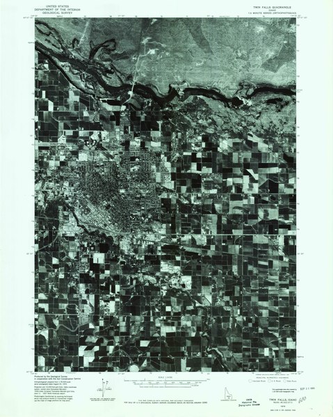
Size of this JPG preview of this TIF file: 479 × 599 pixels. Other resolutions: 192 × 240 pixels | 384 × 480 pixels | 614 × 768 pixels | 819 × 1,024 pixels | 1,637 × 2,048 pixels | 6,433 × 8,046 pixels.
Original file (6,433 × 8,046 pixels, file size: 11.76 MB, MIME type: image/tiff, 8 pages)
Captions
Captions
Add a one-line explanation of what this file represents
Summary[edit]
| Description |
English: Twin Falls Quandragle, Idaho, 7.5 Minute Series (Orthophotoquand), Orthophotograph prepared from 1:78.000-scale aerial photographs taken August 20, 1976. |
| Date | |
| Source | topoView USGS topographic maps. Twin Falls, ID, 1976 (HTMC 1980 ed.) Scale 1:24000 |
| Author | United States Geological Survey |
Licensing[edit]
This image is in the public domain in the United States because it only contains materials that originally came from the United States Geological Survey, an agency of the United States Department of the Interior. For more information, see the official USGS copyright policy.
|
File history
Click on a date/time to view the file as it appeared at that time.
| Date/Time | Thumbnail | Dimensions | User | Comment | |
|---|---|---|---|---|---|
| current | 12:31, 2 May 2021 |  | 6,433 × 8,046, 8 pages (11.76 MB) | Krib (talk | contribs) | Uploaded a work by United States Geological Survey from [https://ngmdb.usgs.gov/topoview/viewer/#11/42.5594/-114.4554 ''topoView USGS topographic maps.''] Twin Falls, ID, 1976 (HTMC 1980 ed.) Scale 1:24000 with UploadWizard |
You cannot overwrite this file.
File usage on Commons
There are no pages that use this file.