File:Houston, Texas (Satellit picture).tif

Original file (8,033 × 16,528 pixels, file size: 379.88 MB, MIME type: image/tiff)
Captions
Captions
Summary[edit]
| Warning | The original file is very high-resolution. It might not load properly or could cause your browser to freeze when opened at full size. |
|---|
| Description |
English: Houston, Texas, US, is featured in this image captured by the Copernicus Sentinel-1 mission.
The two identical Copernicus Sentinel-1 satellites carry radar instruments to image Earth’s surface. Images acquired with radar are interpreted by studying the intensity of the signal scattered back to the satellite – which is related to the roughness of the ground. The colours of this week’s image come from the combination of two polarisations from the Copernicus Sentinel-1 radar mission, which have been converted into a single RGB image. Interpreting polarisation can help scientists analyse Earth’s surface. In this composite image, captured on 21 June 2019, the city of Houston appears in shades of white and grey which contrasts with the yellow tones of the surrounding land and the dark blue waters of the Gulf of Mexico. With a population of over two million and covering an area of over 1600 sq km, Houston is the state’s most populous city and the fourth largest city in the US. Houston is dissected by a series of bayous passing. Buffalo Bayou can be seen cutting through Houston, before joining Galveston Bay visible at the bottom of the image. Galveston Bay is around 55 km long and around 30 km wide, making it the largest estuary in Texas. The shallow bay has an average depth of around 2 m, which is unusually shallow for its size. The Port of Houston, which spreads across the northwest section of the bay, is one of the world’s largest ports, and many ships can be seen as multi coloured dots in the bottom-right of the image. Houston is home to the NASA Lyndon B. Johnson Space Center, which lies west of Galveston Bay. The centre acts as NASA’s lead centre for astronaut training as well as the International Space Station mission operations. It was identified as mission control or simply ‘Houston’ during the Apollo, Gemini and Space Shuttle flights. The centre also collaborates with other international facilities in a variety of scientific and engineering programmes related to human space flight and planetary exploration. The Johnson Space Center is where many ESA astronauts are sent as part of their training and preparation for future space missions. This is where Luca Parmitano, who recently returned to Earth, trained for his Beyond mission to the International Space Station. |
| Date | Taken on 21 June 2019 |
| Source | https://www.esa.int/ESA_Multimedia/Images/2020/02/Houston_Texas#.XmfeJoGGdO0.link |
| Author | ESA |
| Other versions |
|

Licensing[edit]
This media was created by the European Space Agency (ESA).
Where expressly so stated, images or videos are covered by the Creative Commons Attribution-ShareAlike 3.0 IGO (CC BY-SA 3.0 IGO) licence, ESA being an Intergovernmental Organisation (IGO), as defined by the CC BY-SA 3.0 IGO licence. The user is allowed under the terms and conditions of the CC BY-SA 3.0 IGO license to Reproduce, Distribute and Publicly Perform the ESA images and videos released under CC BY-SA 3.0 IGO licence and the Adaptations thereof, without further explicit permission being necessary, for as long as the user complies with the conditions and restrictions set forth in the CC BY-SA 3.0 IGO licence, these including that:
See the ESA Creative Commons copyright notice for complete information, and this article for additional details.
|
 | |
This file is licensed under the Creative Commons Attribution-ShareAlike 3.0 IGO license. Attribution: ESA, CC BY-SA IGO 3.0
| ||

|
This image contains data from a satellite in the Copernicus Programme, such as Sentinel-1, Sentinel-2 or Sentinel-3. Attribution is required when using this image.
Attribution: Contains modified Copernicus Sentinel data 2020
The use of Copernicus Sentinel Data is regulated under EU law (Commission Delegated Regulation (EU) No 1159/2013 and Regulation (EU) No 377/2014). Relevant excerpts:
Free access shall be given to GMES dedicated data [...] made available through GMES dissemination platforms [...].
Access to GMES dedicated data [...] shall be given for the purpose of the following use in so far as it is lawful:
GMES dedicated data [...] may be used worldwide without limitations in time.
GMES dedicated data and GMES service information are provided to users without any express or implied warranty, including as regards quality and suitability for any purpose. |
File history
Click on a date/time to view the file as it appeared at that time.
| Date/Time | Thumbnail | Dimensions | User | Comment | |
|---|---|---|---|---|---|
| current | 18:40, 10 March 2020 | 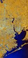 | 8,033 × 16,528 (379.88 MB) | Killarnee (talk | contribs) | {{Information |Description={{en|Houston, Texas, US, is featured in this image captured by the Copernicus Sentinel-1 mission. The two identical Copernicus Sentinel-1 satellites carry radar instruments to image Earth’s surface. Images acquired with radar are interpreted by studying the intensity of the signal scattered back to the satellite – which is related to the roughness of the ground. The colours of this week’s image come from the combination of two polarisations from the Copernicus Sen... |
You cannot overwrite this file.
File usage on Commons
The following 3 pages use this file: