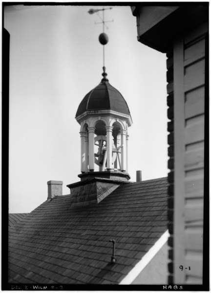
File:Historic American Buildings Survey Edward M. Rosenfeld, Photographer. April 19, 1934 CUPOLA DETAIL - Brandywine Academy, 5 Vandever Avenue, Wilmington, New Castle County, DE HABS DEL,2-WILM,8-2.tif
Jump to navigation
Jump to search
Size of this JPG preview of this TIF file: 432 × 599 pixels. Other resolutions: 173 × 240 pixels | 346 × 480 pixels | 554 × 768 pixels | 739 × 1,024 pixels | 1,477 × 2,048 pixels | 3,602 × 4,993 pixels.
Original file (3,602 × 4,993 pixels, file size: 17.15 MB, MIME type: image/tiff)
Captions
Captions
Add a one-line explanation of what this file represents
Summary[edit]
| Historic American Buildings Survey Edward M. Rosenfeld, Photographer. April 19, 1934 CUPOLA DETAIL - Brandywine Academy, 5 Vandever Avenue, Wilmington, New Castle County, DE
( |
||||||||||||||||||||||||
|---|---|---|---|---|---|---|---|---|---|---|---|---|---|---|---|---|---|---|---|---|---|---|---|---|
| Photographer |
Edward M. Rosenfeld |
|||||||||||||||||||||||
| Title |
Historic American Buildings Survey Edward M. Rosenfeld, Photographer. April 19, 1934 CUPOLA DETAIL - Brandywine Academy, 5 Vandever Avenue, Wilmington, New Castle County, DE |
|||||||||||||||||||||||
| Depicted place | Delaware; New Castle County; Wilmington | |||||||||||||||||||||||
| Date | 19 April 1934 | |||||||||||||||||||||||
| Dimensions | height: 7 in (17.7 cm); width: 5 in (12.7 cm) | |||||||||||||||||||||||
| Collection |
|
|||||||||||||||||||||||
| Current location |
Prints and Photographs Division Washington, D.C. 20540 USA http://hdl.loc.gov/loc.pnp/pp.print |
|||||||||||||||||||||||
| Accession number |
HABS DEL,2-WILM,8-2 |
|||||||||||||||||||||||
| Credit line |
|
|||||||||||||||||||||||
| Source |
|
|||||||||||||||||||||||
| Permission (Reusing this file) |
|
|||||||||||||||||||||||


| Camera location | | View this and other nearby images on: OpenStreetMap |
|---|
File history
Click on a date/time to view the file as it appeared at that time.
| Date/Time | Thumbnail | Dimensions | User | Comment | |
|---|---|---|---|---|---|
| current | 10:57, 10 July 2014 |  | 3,602 × 4,993 (17.15 MB) | Fæ (talk | contribs) | GWToolset: Creating mediafile for Fæ. HABS 09 July 2014 (801:1000) |
You cannot overwrite this file.
File usage on Commons
The following page uses this file: