File:Heard mcdonald 76.jpg
Jump to navigation
Jump to search

Size of this preview: 800 × 272 pixels. Other resolutions: 320 × 109 pixels | 1,267 × 431 pixels.
Original file (1,267 × 431 pixels, file size: 64 KB, MIME type: image/jpeg)
Captions
Captions
Add a one-line explanation of what this file represents
Summary[edit]
| Description |
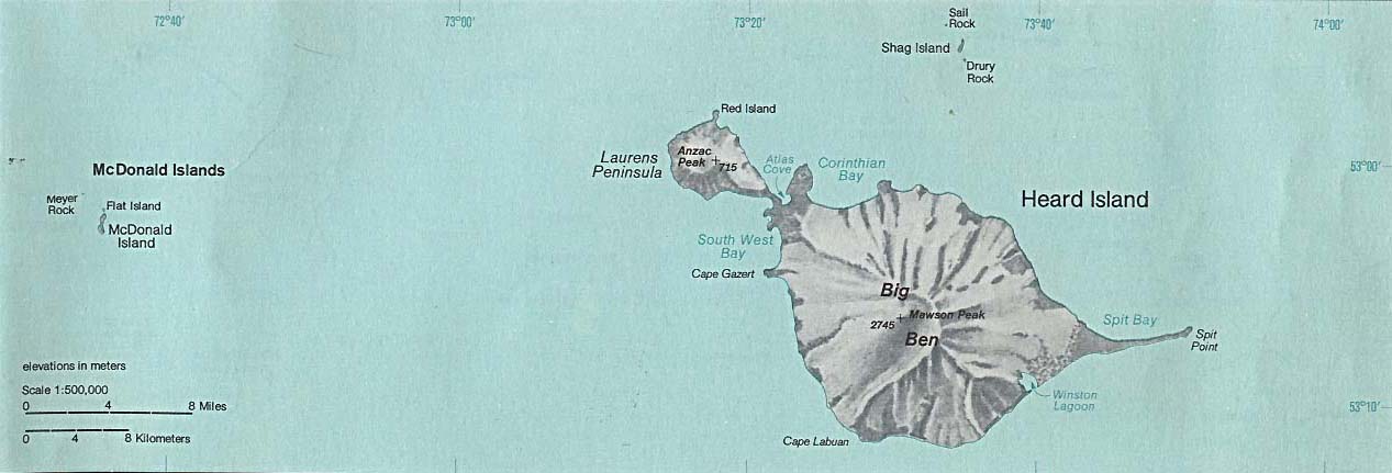
Deutsch: Karte der Heard- und McDonaldinseln im südlichen Indischen Ozean
English: Map of Heard Island and McDonald Islands in the Southern Ocean
Français : Carte d’île Heard et îles McDonald dans l’océan Indien |
| Date | |
| Source | http://www.lib.utexas.edu/maps/islands_oceans_poles/heard_mcdonald_76.jpg |
| Author | Taken from Perry-Castañeda Library (PCL), originally from CIA Indian Ocean Atlas |
Licensing[edit]
| This image is a work of a Central Intelligence Agency employee, taken or made as part of that person's official duties. As a Work of the United States Government, this image or media is in the public domain in the United States.
|

|
File history
Click on a date/time to view the file as it appeared at that time.
| Date/Time | Thumbnail | Dimensions | User | Comment | |
|---|---|---|---|---|---|
| current | 05:28, 3 February 2005 | 1,267 × 431 (64 KB) | Dysprosia~commonswiki (talk | contribs) | {{PD-PCL|http://www.lib.utexas.edu/maps/islands_oceans_poles/heard_mcdonald_76.jpg}} |
You cannot overwrite this file.
File usage on Commons
The following 30 pages use this file:
- Atlas of Heard Island and McDonald Islands
- Template:WatchlistNotice/Wizard/Data
- Template:WatchlistNotice/Wizard/Data/ar
- Template:WatchlistNotice/Wizard/Data/be-tarask
- Template:WatchlistNotice/Wizard/Data/bn
- Template:WatchlistNotice/Wizard/Data/countries
- Template:WatchlistNotice/Wizard/Data/da
- Template:WatchlistNotice/Wizard/Data/de
- Template:WatchlistNotice/Wizard/Data/en
- Template:WatchlistNotice/Wizard/Data/eo
- Template:WatchlistNotice/Wizard/Data/fi
- Template:WatchlistNotice/Wizard/Data/fr
- Template:WatchlistNotice/Wizard/Data/gl
- Template:WatchlistNotice/Wizard/Data/gu
- Template:WatchlistNotice/Wizard/Data/ja
- Template:WatchlistNotice/Wizard/Data/lb
- Template:WatchlistNotice/Wizard/Data/mk
- Template:WatchlistNotice/Wizard/Data/mr
- Template:WatchlistNotice/Wizard/Data/nl
- Template:WatchlistNotice/Wizard/Data/pl
- Template:WatchlistNotice/Wizard/Data/ps
- Template:WatchlistNotice/Wizard/Data/pt
- Template:WatchlistNotice/Wizard/Data/ru
- Template:WatchlistNotice/Wizard/Data/sv
- Template:WatchlistNotice/Wizard/Data/tr
- Template:WatchlistNotice/Wizard/Data/uk
- Help:Watchlist messages/Wizard
- Category:Heard Island
- Category:Heard Island and McDonald Islands
- Category:Maps of Heard Island and McDonald Islands
File usage on other wikis
The following other wikis use this file:
- Usage on ar.wikipedia.org
- Usage on arz.wikipedia.org
- Usage on az.wikipedia.org
- Usage on ca.wikipedia.org
- Usage on ceb.wikipedia.org
- Usage on de.wikipedia.org
- Heard und McDonaldinseln
- McDonald-Inseln
- Heard (Insel)
- Heard Island and McDonald Islands Marine Reserve
- Benutzer:Schneffe himself/2012
- Anzac Peak
- Campbell Peak
- Church Rock (Heard)
- Drury Rock
- Shag Island (Heard und McDonaldinseln)
- Sail Rock (Heard und McDonaldinseln)
- McDonald Island (McDonald-Inseln)
- Meyer Rock
- Red Island (Heard und McDonaldinseln)
- Spit Bay
- Spit Point (Heard)
- Usage on de.wikivoyage.org
- Usage on el.wikipedia.org
- Usage on en.wikipedia.org
- Usage on es.wikipedia.org
- Usage on fa.wikipedia.org
- Usage on fi.wikipedia.org
- Usage on frr.wikipedia.org
- Usage on fr.wikipedia.org
- Usage on gl.wikipedia.org
- Usage on he.wikipedia.org
- Usage on hi.wikipedia.org
- Usage on hr.wikipedia.org
- Usage on hu.wikipedia.org
- Usage on is.wikipedia.org
- Usage on kk.wikipedia.org
- Usage on lb.wikipedia.org
- Usage on lld.wikipedia.org
- Usage on nn.wikipedia.org
- Usage on pl.wikipedia.org
- Usage on ro.wikipedia.org
- Usage on ru.wikipedia.org
- Usage on sh.wikipedia.org
- Usage on sv.wikipedia.org
View more global usage of this file.