File:HAER GU-5-A-4 Guam Tracking Station.tif
Jump to navigation
Jump to search
Size of this JPG preview of this TIF file: 754 × 599 pixels. Other resolutions: 302 × 240 pixels | 604 × 480 pixels | 966 × 768 pixels | 1,280 × 1,017 pixels | 2,560 × 2,035 pixels | 10,060 × 7,996 pixels.
Original file (10,060 × 7,996 pixels, file size: 76.78 MB, MIME type: image/tiff, 2 pages)
Captions
Captions
Add a one-line explanation of what this file represents
Summary[edit]
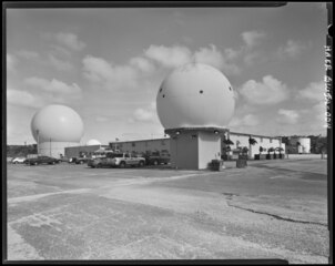
| Description | Guam Tracking Station, Various Radomes & Radome 36 Guam--A (left), North East Elevation, Technical Facility 32 and Barracks Facility 34 and Water Tank, Facing Southwest - Andersen Air Force Base, Northwest Field, Guam Tracking Station, Ritidian Point Quadrangle, Yigo, Guam, GU | ||||
| Date | Unknown date | ||||
| Source |
|
||||
| Author | David R. Castro | ||||
| Other versions |


.jpg)
Licensing[edit]
| This image or media file contains material based on a work of a National Park Service employee, created as part of that person's official duties. As a work of the U.S. federal government, such work is in the public domain in the United States. See the NPS website and NPS copyright policy for more information. |
File history
Click on a date/time to view the file as it appeared at that time.
| Date/Time | Thumbnail | Dimensions | User | Comment | |
|---|---|---|---|---|---|
| current | 22:46, 16 March 2024 | 10,060 × 7,996, 2 pages (76.78 MB) | Recoil16 (talk | contribs) | {{Information |Description= |Source={{LOC-image|gu0025|pnp}} |Date={{other date|?}} |Author=David R. Castro |Permission={{HABS-source}} |other_versions= }} ==License== {{PD-USGov-NPS}} Category:Northwest Field, Guam |
You cannot overwrite this file.
File usage on Commons
The following page uses this file: