File:Gvinea propia, nec non Nigritiæ vel Terræ Nigrorvm maxima pars - geographis hodiernis dicta utraq(ue) Æthiopia inferior, & hujus quidem pars australis LOC 96687096.jpg
Jump to navigation
Jump to search
Size of this preview: 667 × 600 pixels. Other resolutions: 267 × 240 pixels | 534 × 480 pixels | 854 × 768 pixels | 1,139 × 1,024 pixels | 2,278 × 2,048 pixels | 6,750 × 6,069 pixels.
Original file (6,750 × 6,069 pixels, file size: 7.79 MB, MIME type: image/jpeg)
Captions
Captions
Add a one-line explanation of what this file represents
Summary[edit]
| Description |
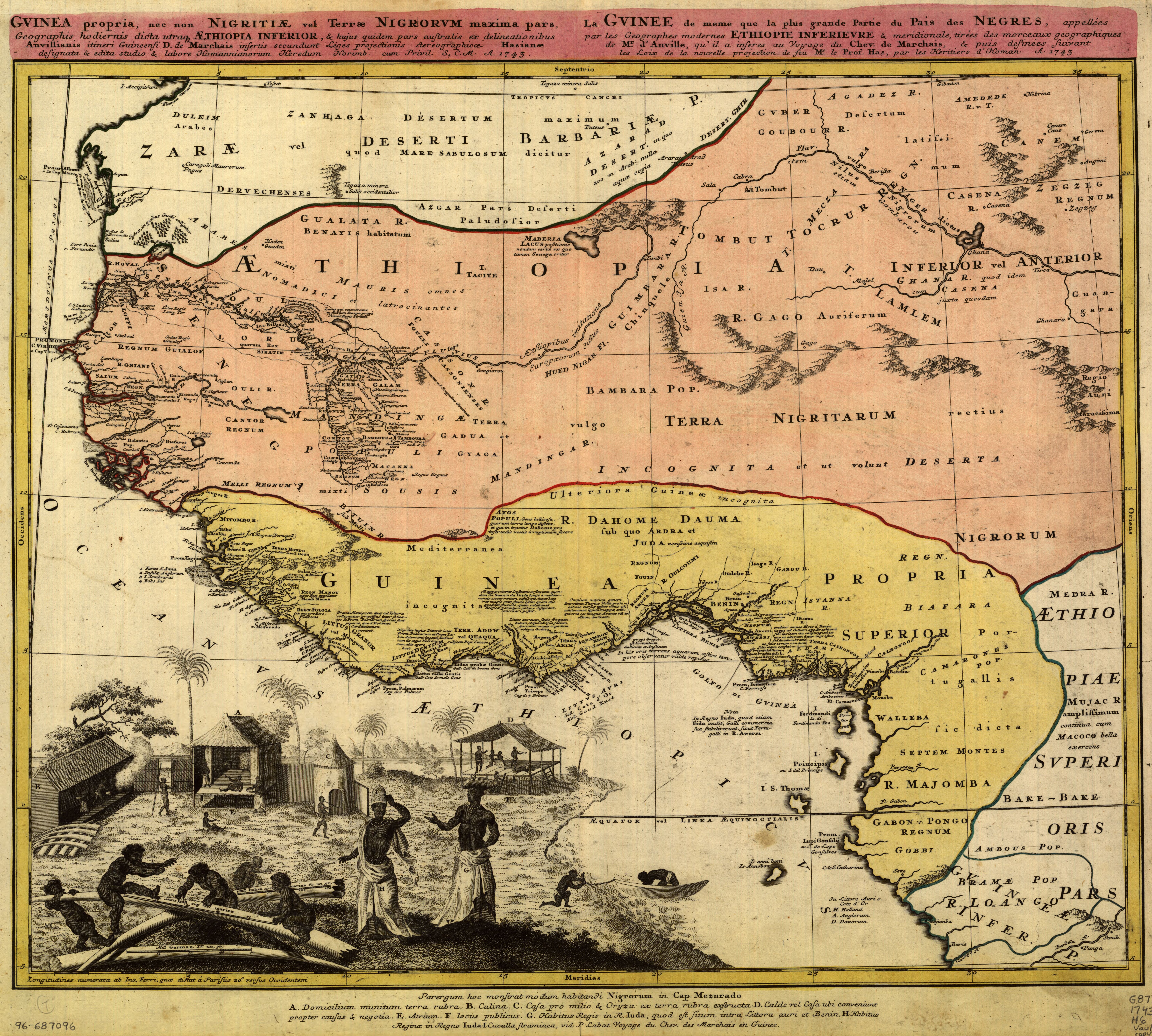
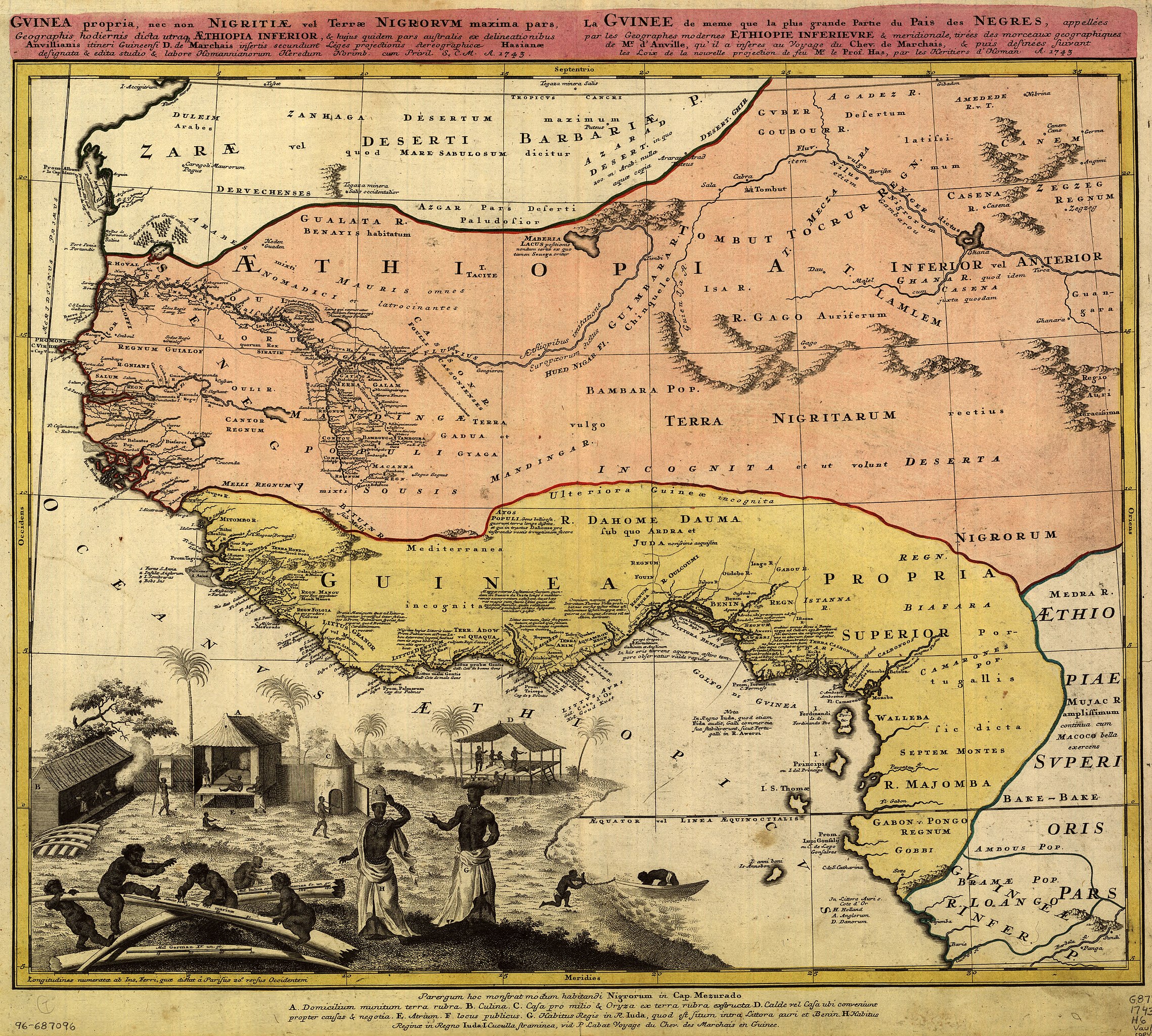
English: Covers West Africa from Gabon in the south to Niger, Mali, and Mauritania in the north. Relief shown pictorially. Prime meridian: Ferro. Available also through the Library of Congress Web site as a raster image. Includes indexed ill. depicting the dress, dwellings, and work of native Africans. Item 59 in LC G&M Leo Belgicus exhibit, Nov. 1993 to May 1994. Three copies. Copy 1 has land areas colored green and yellow and border colored pink. Copy 2 has land areas colored pink and yellow, border colored yellow, and title/upper margin area colored pink; and "10" annotated in upper right corner. Copy 3 has land areas colored pink and yellow and border colored green; and "9" annotated in upper right corner. Vault |
||
| Title | Gvinea propia, nec non Nigritiæ vel Terræ Nigrorvm maxima pars : geographis hodiernis dicta utraq[ue] Æthiopia inferior, & hujus quidem pars australis | ||
| Shelf ID | G8735 1743 .H6 | ||
| Date | |||
| Source | https://www.loc.gov/item/96687096/ | ||
| Author | Homann Erben (Firm); Anville, Jean Baptiste Bourguignon D; Marchais, R. De | ||
| Permission (Reusing this file) |
|
||
| Other versions |
|
||
| Location | West Africa · Africa, West | ||
| Part of | American Memory · General Maps · Catalog · Geography And Map Division | ||
| Subject | Maps · Early Works To 1800 · Africa, West |


_%C3%86thiopia_inferior,_%26_hujus_quidem_pars_australis_LOC_96687096.jpg&action=edit§ion=1)
Licensing[edit]
_%C3%86thiopia_inferior,_%26_hujus_quidem_pars_australis_LOC_96687096.jpg&action=edit§ion=2)
|
This is a faithful photographic reproduction of a two-dimensional, public domain work of art. The work of art itself is in the public domain for the following reason:
The official position taken by the Wikimedia Foundation is that "faithful reproductions of two-dimensional public domain works of art are public domain".
This photographic reproduction is therefore also considered to be in the public domain in the United States. In other jurisdictions, re-use of this content may be restricted; see Reuse of PD-Art photographs for details. | ||||
File history
Click on a date/time to view the file as it appeared at that time.
| Date/Time | Thumbnail | Dimensions | User | Comment | |
|---|---|---|---|---|---|
| current | 05:09, 23 May 2018 | | 6,750 × 6,069 (7.79 MB) | Fæ (talk | contribs) | LOC Maps https://www.loc.gov/item/96687096/ #13582 |
You cannot overwrite this file.
File usage on Commons
The following page uses this file:
_Æthiopia_inferior,_%26_hujus_quidem_pars_australis_LOC_96687096.jpg&oldid=741837069)