File:Guadeloupe creole 2010-03-30.JPG
Jump to navigation
Jump to search
Size of this preview: 800 × 536 pixels. Other resolutions: 320 × 214 pixels | 640 × 428 pixels | 1,024 × 685 pixels | 1,280 × 857 pixels | 2,560 × 1,714 pixels | 3,872 × 2,592 pixels.
Original file (3,872 × 2,592 pixels, file size: 3.86 MB, MIME type: image/jpeg)
Captions
Captions
Add a one-line explanation of what this file represents
Summary[edit]
| Description |
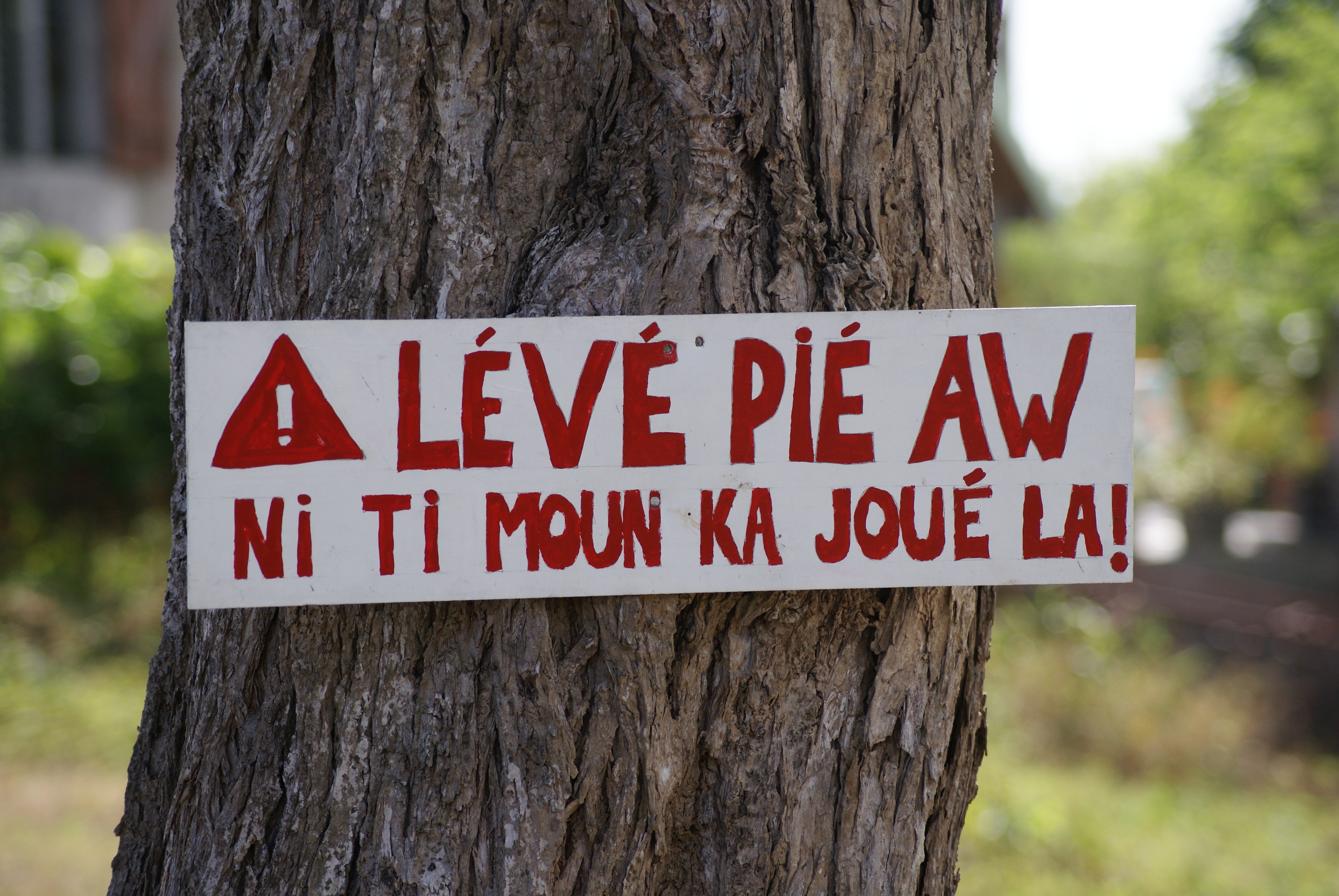
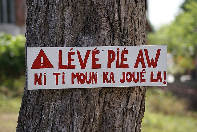
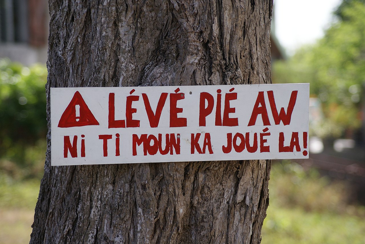
English: Sign in Guadeloupe creole on tree in a residental area (Lamarre, unincorporated) near Sainte Anne, Guadeloupe, France. Translation: "Lift [your] foot (i.e., slow down), children are playing here!".
Français : Panonceau en créole dans une zone résidentielle (lieu dit Lamarre), dans les grands fonds de Sainte Anne, en Guadeloupe (France). Traduction: Levez le [votre] pied, il y a des enfants qui jouent ici.
Guadeloupéen/Guadeloupean Creole French: "Lévé pié aw - Ni ti moun ka joué la!" |
| Date | |
| Source | Own work Translations: [1][2] |
| Author | Kim Hansen |
| Camera location | | View this and other nearby images on: OpenStreetMap |
|---|
Licensing[edit]
I, the copyright holder of this work, hereby publish it under the following licenses:
This file is licensed under the Creative Commons Attribution-Share Alike 3.0 Unported license.
- You are free:
- to share – to copy, distribute and transmit the work
- to remix – to adapt the work
- Under the following conditions:
- attribution – You must give appropriate credit, provide a link to the license, and indicate if changes were made. You may do so in any reasonable manner, but not in any way that suggests the licensor endorses you or your use.
- share alike – If you remix, transform, or build upon the material, you must distribute your contributions under the same or compatible license as the original.

|
Permission is granted to copy, distribute and/or modify this document under the terms of the GNU Free Documentation License, Version 1.2 or any later version published by the Free Software Foundation; with no Invariant Sections, no Front-Cover Texts, and no Back-Cover Texts. A copy of the license is included in the section entitled GNU Free Documentation License. |
You may select the license of your choice.
This image has been assessed using the Quality image guidelines and is considered a Quality image.
|

|
This image has been assessed under the valued image criteria and is considered the most valued image on Commons within the scope: Guadeloupe Creole. You can see its nomination here. |
File history
Click on a date/time to view the file as it appeared at that time.
| Date/Time | Thumbnail | Dimensions | User | Comment | |
|---|---|---|---|---|---|
| current | 02:20, 31 March 2010 | | 3,872 × 2,592 (3.86 MB) | Slaunger (talk | contribs) | {{Information |Description={{en|Sign in Guadeloupe creole on tree in residental area in the village of Lamarre, Guadeloupe.}} |Source={{own}} |Date=2010-03-30 |Author=Kim Hansen |Permission=See below |other_versions= }} [[Category:Ph |
You cannot overwrite this file.
File usage on Commons
The following 12 pages use this file:
- User:Slaunger/France
- User:Slaunger/France/Guadeloupe
- User:Slaunger/France/Guadeloupe/Objects
- User talk:Slaunger/Archives/QIC
- User talk:Slaunger/Archives/VIC
- Commons:Files used on the OpenStreetMap Wiki/16
- Commons:Quality images/Subject/Places/Man made structures/Buildings, Exterior/Part 1a
- Commons:Quality images candidates/Archives April 2010
- Commons:Valued image candidates/Guadeloupe creole 2010-03-30.JPG
- Commons:Valued images by topic/Concepts and ideas/Social and cultural
- Commons talk:Quality images/Subject/Places/Man made structures
- Category:Creole languages
File usage on other wikis
The following other wikis use this file:
- Usage on af.wikipedia.org
- Usage on ami.wikipedia.org
- Usage on ar.wikipedia.org
- Usage on ast.wikipedia.org
- Usage on be.wikipedia.org
- Usage on ca.wikipedia.org
- Usage on da.wikipedia.org
- Usage on el.wikipedia.org
- Usage on en.wikipedia.org
- Guadeloupe
- Creole language
- Talk:Creole language
- Antillean Creole
- Wikipedia:Reference desk/Archives/Language/2010 March 31
- Wikipedia:Featured picture candidates/June-2011
- Wikipedia:Featured picture candidates/Guadeloupe Creole Roadsign
- Linguistic landscape
- User:HappyWikiContributor/sandbox
- Talk:Guadeloupe/Archive 1
- Usage on en.wikiversity.org
- Usage on en.wikivoyage.org
- Usage on eo.wikipedia.org
- Usage on es.wikipedia.org
- Usage on fr.wikipedia.org
- Usage on fr.wikiversity.org
- Usage on fr.wiktionary.org
- Usage on fy.wikipedia.org
- Usage on gcr.wikipedia.org
- Usage on ht.wikipedia.org
- Usage on hu.wikipedia.org
- Usage on hy.wikipedia.org
- Usage on ia.wikipedia.org
- Usage on id.wikipedia.org
- Usage on incubator.wikimedia.org
- Usage on is.wikipedia.org
- Usage on ka.wikipedia.org
- Usage on ko.wikipedia.org
- Usage on nds-nl.wikipedia.org
- Usage on oc.wikipedia.org
- Usage on pap.wikipedia.org
View more global usage of this file.