File:Great Salt Lake by Sentinel-2.jpg

Original file (7,536 × 7,180 pixels, file size: 38.85 MB, MIME type: image/jpeg)
Captions
Captions
Summary[edit]
| Description |
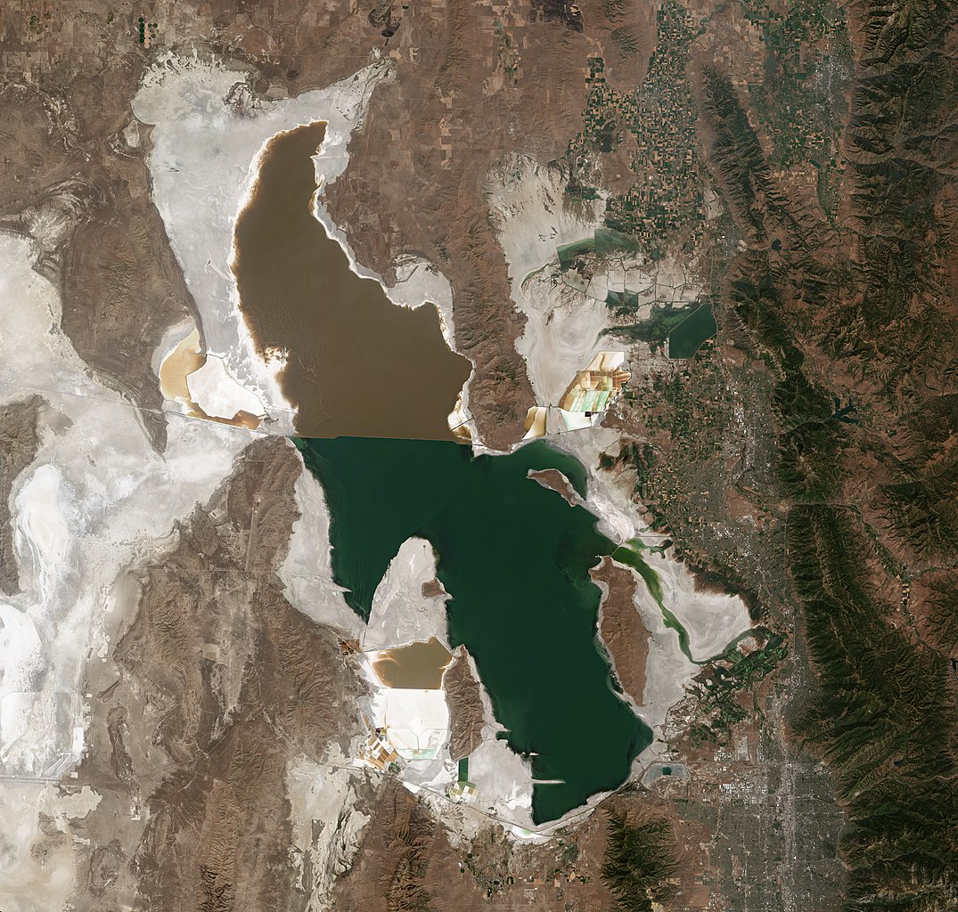
English: Satellite photo of the Great Salt Lake from August 2018 after years of drought, reaching near-record lows. The difference in colors between the northern and southern portions of the lake is the result of the Lucin Cutoff, a railroad causeway. The image was acquired by the MSI sensor on the Sentinel-2B satellite (Resolution: 20m, RGB Composites: True color, Band 4-3-2). |
| Date | |
| Source | https://scihub.copernicus.eu/dhus/#/home |
| Author | Copernicus Sentinel-2, ESA |
| Other versions |
Original 10m-Res Version (Large File Size) .jpg) |
Licensing[edit]
- You are free:
- to share – to copy, distribute and transmit the work
- to remix – to adapt the work
- Under the following conditions:
- attribution – You must give appropriate credit, provide a link to the license, and indicate if changes were made. You may do so in any reasonable manner, but not in any way that suggests the licensor endorses you or your use.
- share alike – If you remix, transform, or build upon the material, you must distribute your contributions under the same or compatible license as the original.

|
This image contains data from a satellite in the Copernicus Programme, such as Sentinel-1, Sentinel-2 or Sentinel-3. Attribution is required when using this image.
Attribution: Contains modified Copernicus Sentinel data 2018
The use of Copernicus Sentinel Data is regulated under EU law (Commission Delegated Regulation (EU) No 1159/2013 and Regulation (EU) No 377/2014). Relevant excerpts:
Free access shall be given to GMES dedicated data [...] made available through GMES dissemination platforms [...].
Access to GMES dedicated data [...] shall be given for the purpose of the following use in so far as it is lawful:
GMES dedicated data [...] may be used worldwide without limitations in time.
GMES dedicated data and GMES service information are provided to users without any express or implied warranty, including as regards quality and suitability for any purpose. |
File history
Click on a date/time to view the file as it appeared at that time.
| Date/Time | Thumbnail | Dimensions | User | Comment | |
|---|---|---|---|---|---|
| current | 10:08, 13 April 2019 | | 7,536 × 7,180 (38.85 MB) | Satview (talk | contribs) | User created page with UploadWizard |
You cannot overwrite this file.
File usage on Commons
The following 3 pages use this file:
File usage on other wikis
The following other wikis use this file:
- Usage on af.wikipedia.org
- Usage on ar.wikipedia.org
- Usage on bh.wikipedia.org
- Usage on bn.wikipedia.org
- Usage on ca.wikipedia.org
- Usage on cs.wikipedia.org
- Usage on cy.wikipedia.org
- Usage on de.wikipedia.org
- Usage on en.wikipedia.org
- Usage on en.wikivoyage.org
- Usage on es.wikivoyage.org
- Usage on nn.wikipedia.org
- Usage on sl.wikipedia.org
- Usage on www.wikidata.org
- Usage on zh-yue.wikipedia.org
Metadata
- Satellite pictures of Great Salt Lake
- Landforms bordering the Great Salt Lake
- Promontory Mountains
- Antelope Island
- Stansbury Island
- Fremont Island
- Hogup Mountains
- Curlew Valley
- Hansel Mountains
- North Promontory Mountains
- Blue Creek Valley
- Lakeside Mountains
- Puddle Valley
- Grassy Mountains
- Cedar Mountains (Tooele County)
- Skull Valley (Utah)
- Stansbury Mountains
- Tooele Valley
- Oquirrh Mountains
- Pink lakes
- Lucin Cutoff
- Photos of the United States by Sentinel-2