File:Goido Rail Yard, CKK20083-C34-38.jpg
Jump to navigation
Jump to search

Size of this preview: 738 × 599 pixels. Other resolutions: 296 × 240 pixels | 591 × 480 pixels | 946 × 768 pixels | 1,277 × 1,037 pixels.
Original file (1,277 × 1,037 pixels, file size: 609 KB, MIME type: image/jpeg)
Captions
Captions
Add a one-line explanation of what this file represents
Summary[edit]
| Description |
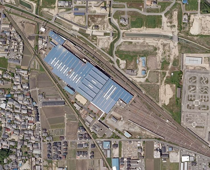
English: Aerial photo of Kintetsu Goido Inspection Depot in Kashiba City, Nara Prefecture, Japan
日本語: 奈良県香芝市狐井にある近畿日本鉄道五位堂研修車庫周辺の空中写真 |
| Date | |
| Source |
English: National Land Image Information (Color Aerial Photographs) (Reference number: CKK20083; Course Number: C34; Photo Number: 38; Date: May 15, 2008; Area: Nara; Height: 2274 metre; Scale: 1/8000; Camera Name: UCX; Focal Distance: 100.500 millimetre; Color Type: Color; Photo Type: Digital; Agency: Geographical Survey Institute of Japan; Municipality: Kashiba City) http://mapps.gsi.go.jp/contentsImageDisplay.do?specificationId=765345&isDetail=false
日本語: 国土画像情報(カラー空中写真)(整理番号:CKK20083、コース番号:C34、写真番号:38、撮影年月日:2008年5月15日、撮影地域:奈良、撮影高度:2274m、撮影縮尺:1/8000、カメラ名称:UCX、焦点距離:100.500mm、カラー種別:カラー、写真種別:デジタル、撮影計画機関:国土地理院、市区町村名:香芝市)http://mapps.gsi.go.jp/contentsImageDisplay.do?specificationId=765345&isDetail=false |
| Author |
English: Geographical Survey Institute of Japan 日本語: 国土地理院 |
Licensing[edit]

|
The copyright holder of this file, Ministry of Land, Infrastructure, Transport and Tourism, allows anyone to use it for any purpose, provided that the copyright holder is properly attributed. Redistribution, derivative work, commercial use, and all other use is permitted. |
Attribution:
National Land Image Information (Color Aerial Photographs), created by Ministry of Land, Infrastructure, Transport and Tourism, distributed by Geospatial Information Authority of Japan
|

File history
Click on a date/time to view the file as it appeared at that time.
| Date/Time | Thumbnail | Dimensions | User | Comment | |
|---|---|---|---|---|---|
| current | 09:12, 1 September 2016 | | 1,277 × 1,037 (609 KB) | Miyuki Meinaka (talk | contribs) | User created page with UploadWizard |
You cannot overwrite this file.
File usage on Commons
The following 2 pages use this file:
File usage on other wikis
The following other wikis use this file:
- Usage on ja.wikipedia.org