File:Germany, German Democratic Republic (+districts) location map w·o FRG 1990.svg
Jump to navigation
Jump to search
_location_map_w%C2%B7o_FRG_1990.svg&redirect=no)

Size of this PNG preview of this SVG file: 469 × 599 pixels. Other resolutions: 188 × 240 pixels | 376 × 480 pixels | 601 × 768 pixels | 802 × 1,024 pixels | 1,604 × 2,048 pixels | 618 × 789 pixels.
Original file (SVG file, nominally 618 × 789 pixels, file size: 3.87 MB)
Captions
Captions
Add a one-line explanation of what this file represents
I, the copyright holder of this work, hereby publish it under the following license:
This file is licensed under the Creative Commons Attribution-Share Alike 2.5 Generic license.
- You are free:
- to share – to copy, distribute and transmit the work
- to remix – to adapt the work
- Under the following conditions:
- attribution – You must give appropriate credit, provide a link to the license, and indicate if changes were made. You may do so in any reasonable manner, but not in any way that suggests the licensor endorses you or your use.
- share alike – If you remix, transform, or build upon the material, you must distribute your contributions under the same or compatible license as the original.
File history
Click on a date/time to view the file as it appeared at that time.
| Date/Time | Thumbnail | Dimensions | User | Comment | |
|---|---|---|---|---|---|
| current | 18:30, 27 October 2013 | | 618 × 789 (3.87 MB) | TUBS (talk | contribs) | inseln zurück an ddr |
| 12:36, 27 October 2013 |  | 618 × 789 (3.95 MB) | TUBS (talk | contribs) | ||
| 21:06, 26 October 2013 |  | 618 × 789 (2.94 MB) | TUBS (talk | contribs) | -Greifswald Land umschließend dargestellt | |
| 20:50, 26 October 2013 |  | 618 × 789 (2.94 MB) | TUBS (talk | contribs) | ||
| 20:39, 26 October 2013 |  | 618 × 789 (2.94 MB) | TUBS (talk | contribs) | https://de.wikipedia.org/wiki/Wikipedia:Kartenwerkstatt#Kreise_in_der_DDR | |
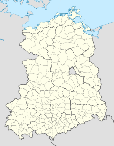
| 07:44, 26 October 2013 |  | 618 × 789 (1.09 MB) | TUBS (talk | contribs) | {{Information |Description= {{de|Kreise und Bezirke der Deutschen Demokratischen Republik Stand Oktober 1990.}} |Source={{own}}{{Adobe Illustrator}}{{AttribSVG|Germany, German Demorcratic Republic location map w... |
You cannot overwrite this file.
File usage on Commons
More than 100 pages use this file. The following list shows the first 100 pages that use this file only. A full list is available.
_location_map_w%C2%B7o_FRG_1990.svg)
- File:Altenburg in German Democratic Republic.svg
- File:Altentreptow in German Democratic Republic.svg
- File:Anklam in German Democratic Republic.svg
- File:Arnstadt in German Democratic Republic.svg
- File:Bad Doberan in German Democratic Republic.svg
- File:Bad Liebenwerda in German Democratic Republic.svg
- File:Bad Salzungen in German Democratic Republic.svg
- File:Bautzen in German Democratic Republic.svg
- File:Berlin in German Democratic Republic.svg
- File:Bischofswerda in German Democratic Republic.svg
- File:Borna in German Democratic Republic.svg
- File:Brand-Erbisdorf in German Democratic Republic.svg
- File:Burg in German Democratic Republic.svg
- File:Bützow in German Democratic Republic.svg
- File:Calau in German Democratic Republic.svg
- File:Cottbus Land in German Democratic Republic.svg
- File:Cottbus in German Democratic Republic.svg
- File:Delitzsch in German Democratic Republic.svg
- File:Demmin in German Democratic Republic.svg
- File:Dippoldiswalde in German Democratic Republic.svg
- File:Dresden Land in German Democratic Republic.svg
- File:Dresden in German Democratic Republic.svg
- File:Döbeln in German Democratic Republic.svg
- File:Eilenburg in German Democratic Republic.svg
- File:Eisenach in German Democratic Republic.svg
- File:Finsterwalde in German Democratic Republic.svg
- File:Forst in German Democratic Republic.svg
- File:Freiberg in German Democratic Republic.svg
- File:Freital in German Democratic Republic.svg
- File:Gadebusch in German Democratic Republic.svg
- File:Gardelegen in German Democratic Republic.svg
- File:Geithain in German Democratic Republic.svg
- File:Genthin in German Democratic Republic.svg
- File:Germany, German Democratic Republic (+districts) location map w·o FRG 1990.svg
- File:Germany, German Demorcratic Republic (+districts) location map w·o FRG 1990.svg (file redirect)
- File:Greifswald in German Democratic Republic.svg
- File:Grevesmühlen in German Democratic Republic.svg
- File:Grimma in German Democratic Republic.svg
- File:Grimmen in German Democratic Republic.svg
- File:Grossenhain in German Democratic Republic.svg
- File:Guben in German Democratic Republic.svg
- File:Görlitz Land in German Democratic Republic.svg
- File:Görlitz in German Democratic Republic.svg
- File:Güstrow in German Democratic Republic.svg
- File:Hagenow in German Democratic Republic.svg
- File:Hainichen in German Democratic Republic.svg
- File:Halberstadt in German Democratic Republic.svg
- File:Haldensleben in German Democratic Republic.svg
- File:Havelberg in German Democratic Republic.svg
- File:Herzberg in German Democratic Republic.svg
- File:Hildburghausen in German Democratic Republic.svg
- File:Hoyerswerda in German Democratic Republic.svg
- File:Ilmenau in German Democratic Republic.svg
- File:Jessen in German Democratic Republic.svg
- File:Kalbe in German Democratic Republic.svg
- File:Kamenz in German Democratic Republic.svg
- File:Leipzig Land in German Democratic Republic.svg
- File:Leipzig in German Democratic Republic.svg
- File:Luckau in German Democratic Republic.svg
- File:Ludwigslust in German Democratic Republic.svg
- File:Löbau in German Democratic Republic.svg
- File:Lübben in German Democratic Republic.svg
- File:Lübz in German Democratic Republic.svg
- File:Malchin in German Democratic Republic.svg
- File:Marienberg in German Democratic Republic.svg
- File:Meissen in German Democratic Republic.svg
- File:Neubrandenburg in German Democratic Republic.svg
- File:Neuhaus in German Democratic Republic.svg
- File:Neustrelitz in German Democratic Republic.svg
- File:Niesky in German Democratic Republic.svg
- File:Oschatz in German Democratic Republic.svg
- File:Oschersleben in German Democratic Republic.svg
- File:Osterburg in German Democratic Republic.svg
- File:Parchim in German Democratic Republic.svg
- File:Pasewalk in German Democratic Republic.svg
- File:Perleberg in German Democratic Republic.svg
- File:Pirna in German Democratic Republic.svg
- File:Prenzlau in German Democratic Republic.svg
- File:Ribnitz-Damgarten in German Democratic Republic.svg
- File:Riesa in German Democratic Republic.svg
- File:Rochlitz in German Democratic Republic.svg
- File:Rostock Land in German Democratic Republic.svg
- File:Rostock in German Democratic Republic.svg
- File:Röbel in German Democratic Republic.svg
- File:Rügen in German Democratic Republic.svg
- File:Salzwedel in German Democratic Republic.svg
- File:Schmalkalden in German Democratic Republic.svg
- File:Schmölln in German Democratic Republic.svg
- File:Schwerin Land in German Democratic Republic.svg
- File:Schwerin in German Democratic Republic.svg
- File:Schönebeck in German Democratic Republic.svg
- File:Sebnitz in German Democratic Republic.svg
- File:Senftenberg in German Democratic Republic.svg
- File:Sonneberg in German Democratic Republic.svg
- File:Spremberg in German Democratic Republic.svg
- File:Stassfurt in German Democratic Republic.svg
- File:Stendal in German Democratic Republic.svg
- File:Sternberg in German Democratic Republic.svg
- File:Stralsund in German Democratic Republic.svg
- File:Strasburg in German Democratic Republic.svg
_location_map_w%C2%B7o_FRG_1990.svg)
View more links to this file.
File usage on other wikis
The following other wikis use this file:
- Usage on de.wikipedia.org
_location_map_w·o_FRG_1990.svg&oldid=756085365)