File:General-Karte der Vereinigten Staaten von Nord Amerika, nebst den grösst. Theilen von Canada and Tejas - mit Bezeichnung sämmtlicher Cantons, deren Haupt-u. Handelstädte, Eisenbahnen, Kunst- and NYPL434841.tiff
Jump to navigation
Jump to search

Size of this JPG preview of this TIF file: 720 × 600 pixels. Other resolutions: 288 × 240 pixels | 576 × 480 pixels | 922 × 768 pixels | 1,229 × 1,024 pixels | 2,458 × 2,048 pixels | 9,407 × 7,837 pixels.
Original file (9,407 × 7,837 pixels, file size: 116.17 MB, MIME type: image/tiff)
Captions
Captions
Add a one-line explanation of what this file represents
Summary[edit]
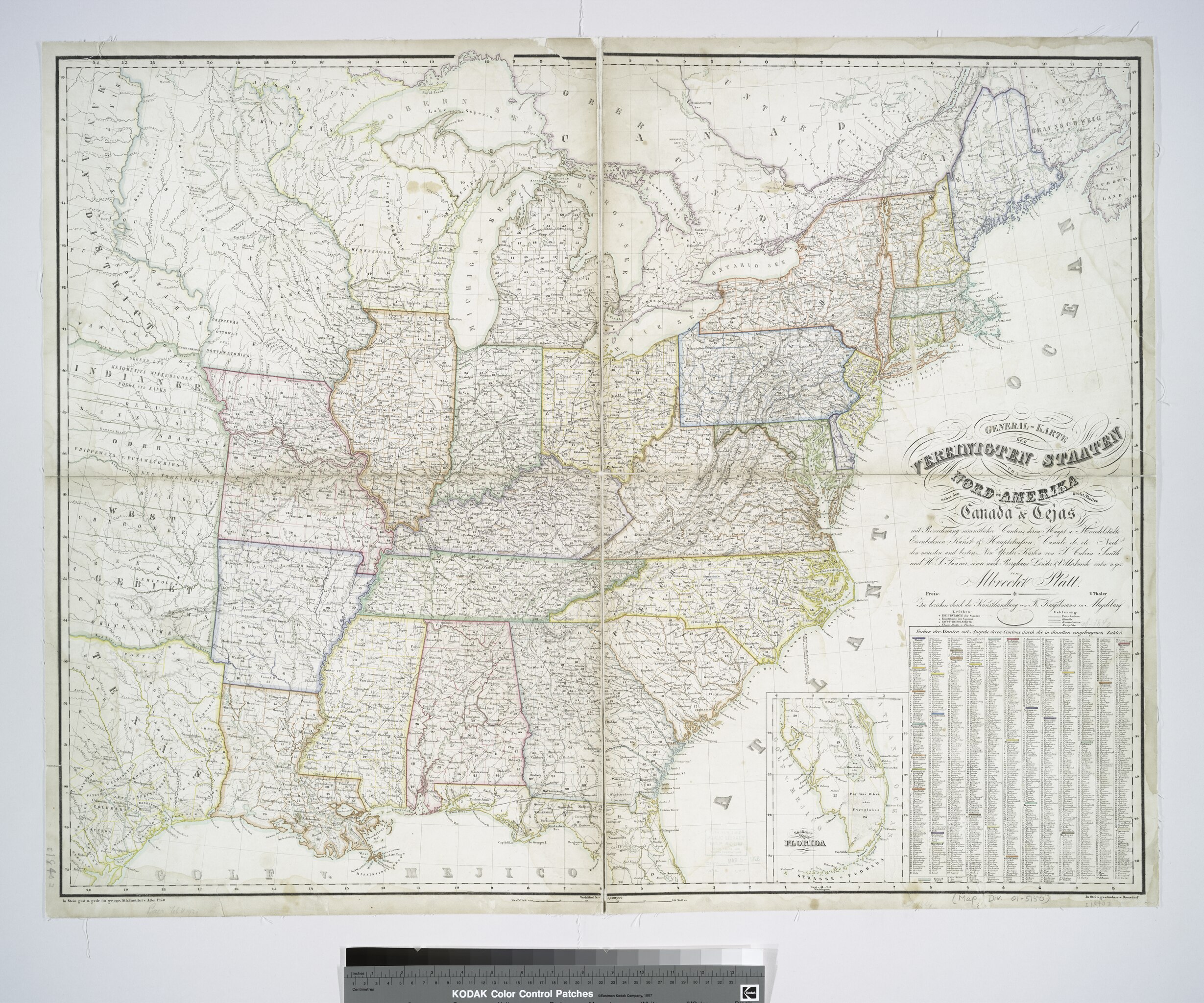
| Description | General-Karte der Vereinigten Staaten von Nord Amerika, nebst den grösst. Theilen von Canada and Tejas : mit Bezeichnung sämmtlicher Cantons, deren Haupt-u. Handelstädte, Eisenbahnen, Kunst- and Hauptstrassen, Canäle etc. etc. / nach den neuesten und besten New-Yorker Karten von J. Calvin Smith und H.S. Tanner, sowie nach Berghaus, Länder-and Völkerkunde entw. y. gez. von Albrecht Platt.; Maps of North America. / Countries / United States (except New York) / Whole | |||||||||||||||||||||||
| Notes | "In Stein gestochen v. Bomsdorf." ''Note 2.'') Includes index for counties. ''Note 3.'') Includes inset: [Southern part of Florida] ''Note 4.'') National Endowment for the Humanities Grant for Access to Early Maps of the Middle Atlantic Seaboard. ''Note 5.'') Prime meridian: Washington, D.C. ''Note 6.'') Shows canals, roads, Indian territories and state boundaries. ''Note 7.'') Relief shown by hachures. | |||||||||||||||||||||||
| Item physical description | 1 map : hand col.; 71 x 91 cm. | |||||||||||||||||||||||
| Catalogue call number | Map Div. 01-5150 | |||||||||||||||||||||||
| Date | circa 1840 | |||||||||||||||||||||||
| Source |
http://digitalgallery.nypl.org/nypldigital/dgkeysearchdetail.cfm?imageID=434841
|
|||||||||||||||||||||||
| Author | Platt, Albert, 1794-1862 -- Cartographer | |||||||||||||||||||||||
| Permission (Reusing this file) |
From The Lionel Pincus and Princess Firyal Map Division. http://maps.nypl.org
|
|||||||||||||||||||||||
| Location | Stephen A. Schwarzman Building / The Lionel Pincus and Princess Firyal Map Division | |||||||||||||||||||||||
| Digital item published | 2-3-2004; updated 3-25-2011 | |||||||||||||||||||||||
| Digital ID | 434841 | |||||||||||||||||||||||

The making of this file was supported by Wikimedia UK.
To see other files made with the support of Wikimedia UK, please see the category Supported by Wikimedia UK.
|
File history
Click on a date/time to view the file as it appeared at that time.
| Date/Time | Thumbnail | Dimensions | User | Comment | |
|---|---|---|---|---|---|
| current | 15:30, 20 June 2016 |  | 9,407 × 7,837 (116.17 MB) | Shattered Gnome (talk | contribs) | Importing file |
| 16:17, 28 April 2014 |  | 7,837 × 9,407 (210.93 MB) | Fæ (talk | contribs) | GWToolset:: Creating mediafile for Fæ. Tranche 3 5495-7474 (2) |
You cannot overwrite this file.
File usage on Commons
There are no pages that use this file.