File:GOES 16 on August 21 2017.jpg
Jump to navigation
Jump to search

Size of this preview: 600 × 600 pixels. Other resolutions: 240 × 240 pixels | 480 × 480 pixels | 768 × 768 pixels | 1,024 × 1,024 pixels | 2,048 × 2,048 pixels | 10,848 × 10,848 pixels.
Original file (10,848 × 10,848 pixels, file size: 140.99 MB, MIME type: image/jpeg)
Captions
Captions
Add a one-line explanation of what this file represents
Summary[edit]
| Description |
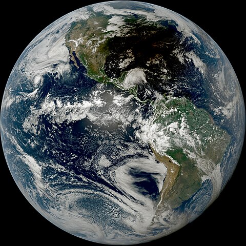
English: This true-color image of the Earth was captured on August 21, 2017, at 18:45 UTC, by the Advanced Baseline Imager (ABI) instrument flying aboard NOAA's preliminary GOES 16 satellite. When this image was taken, the total solar eclipse of August 21, 2017, was ongoing over the North American continent. Also visible in this image is the tropical wave that would eventually become Hurricane Harvey, which was near the Yucatan Peninsula, slightly outside the shadow of the solar eclipse. Hurricane Kenneth was also active in the Pacific Ocean on the far left and visible in this image were wildfires in the Pacific Northwest. |
| Date | |
| Source | AWS S3 Explorer |
| Author | NOAA's GOES 16 Satellite |
Licensing[edit]
This image is in the public domain because it contains materials that originally came from the U.S. National Oceanic and Atmospheric Administration, taken or made as part of an employee's official duties.
|
File history
Click on a date/time to view the file as it appeared at that time.
| Date/Time | Thumbnail | Dimensions | User | Comment | |
|---|---|---|---|---|---|
| current | 21:19, 2 February 2023 | | 10,848 × 10,848 (140.99 MB) | TheWxResearcher (talk | contribs) | Uploaded a work by NOAA's GOES 16 Satellite from [https://registry.opendata.aws/collab/noaa/ AWS S3 Explorer] with UploadWizard |
You cannot overwrite this file.
File usage on Commons
There are no pages that use this file.