File:GOES-11 Sees Approaching Rainmaker to Add to Snowmelt on Columbia River (5754836133).jpg

Original file (3,600 × 3,000 pixels, file size: 1.64 MB, MIME type: image/jpeg)
Captions
Captions
Summary[edit]
.jpg&action=edit§ion=1)
| Description |
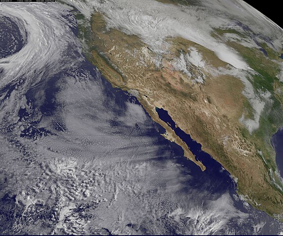
Snowmelt is happening in the Pacific Northwest, and over the next few days water from east of the Cascade Mountains will continue flowing into the lower Columbia River system. Satellite imagery shows that an approaching cold front is likely going to add to the water levels. This image from the GOES-11 satellite on May 24 at 1445 UTC (10:45 a.m. EDT) shows the approach of a strong cold front headed to the Pacific Northwest. The bow-shaped clouds in the top left are associated with that cold front that will bring rain tonight after midnight local time. The system is expected to bring between 3/10ths and 3/4ths an inch of rain tonight and Wednesday in western Oregon, including Portland and Eugene, south to Redding, Calif. Rain is the last thing needed in Oregon, as the National Weather Service issued a Flood watch for the Columbia River at Vancouver affecting Multnomah and Clark Counties today and "until further notice." The GOES series of satellites are managed and operated by NOAA. NASA's GOES Project, located at NASA Goddard, procures and manages the development and launch of the GOES satellites and creates some of the GOES satellite images and GOES satellite imagery animations Rob Gutro NASA's Goddard Space Flight Center Credit: NOAA/NASA GOES Project
Follow us on Twitter Join us on Facebook |
| Date | |
| Source | GOES-11 Sees Approaching Rainmaker to Add to Snowmelt on Columbia River |
| Author | NASA Goddard Space Flight Center from Greenbelt, MD, USA |
Licensing[edit]
.jpg&action=edit§ion=2)
- You are free:
- to share – to copy, distribute and transmit the work
- to remix – to adapt the work
- Under the following conditions:
- attribution – You must give appropriate credit, provide a link to the license, and indicate if changes were made. You may do so in any reasonable manner, but not in any way that suggests the licensor endorses you or your use.
| This image was originally posted to Flickr by NASA Goddard Photo and Video at https://flickr.com/photos/24662369@N07/5754836133. It was reviewed on 27 September 2017 by FlickreviewR and was confirmed to be licensed under the terms of the cc-by-2.0. |
File history
Click on a date/time to view the file as it appeared at that time.
| Date/Time | Thumbnail | Dimensions | User | Comment | |
|---|---|---|---|---|---|
| current | 05:45, 27 September 2017 | | 3,600 × 3,000 (1.64 MB) | A1Cafel (talk | contribs) | Transferred from Flickr via Flickr2Commons |
You cannot overwrite this file.
File usage on Commons
The following page uses this file:
.jpg&oldid=482441158)